METAR & TAF M29
M29 does not publish a METAR.
Showing the nearest reporting station: KSNH (SAVANNAH-HARDIN COUNTY) · 17.7 NM away. Conditions at M29 may differ.
METAR · KSNH
Observed 19:30Z
KSNH 261930Z AUTO 00000KT 10SM CLR 34/26 A2994 RMK A01
- Wind
- 000° @ 0 kt
- Visibility
- 10 SM
- Temp / Dew
- 34°C / 26°C
- Altimeter
- 29.94 inHg
- Clouds
- CLR
- Density alt
- 2,759 ft
- Ceiling
- Unlimited
- Rules
- VFR
Airport info & contacts
Manager on record, flight service, ARTCC, attendance schedule and pattern altitude — published by the FAA and refreshed every 28 days.
Location
- From city
- 1 NM E
- VFR sectional
- ATLANTA
- ARTCC
- ZME · MEMPHIS
- NOTAM facility
- MKL (NOTAM-D)
Airport manager
- Name
- KRISTEEN DUREN
- Phone
- 931-676-3370
- Address
- 142 MAIN STREET, P O BOX 192, CLIFTON TN 38425
Flight service · Hours
- FSS MKL
- JACKSON1-800-WX-BRIEF
- Attendance
- Unattended
Frequencies
Tap any row to copy the frequency to your clipboard.
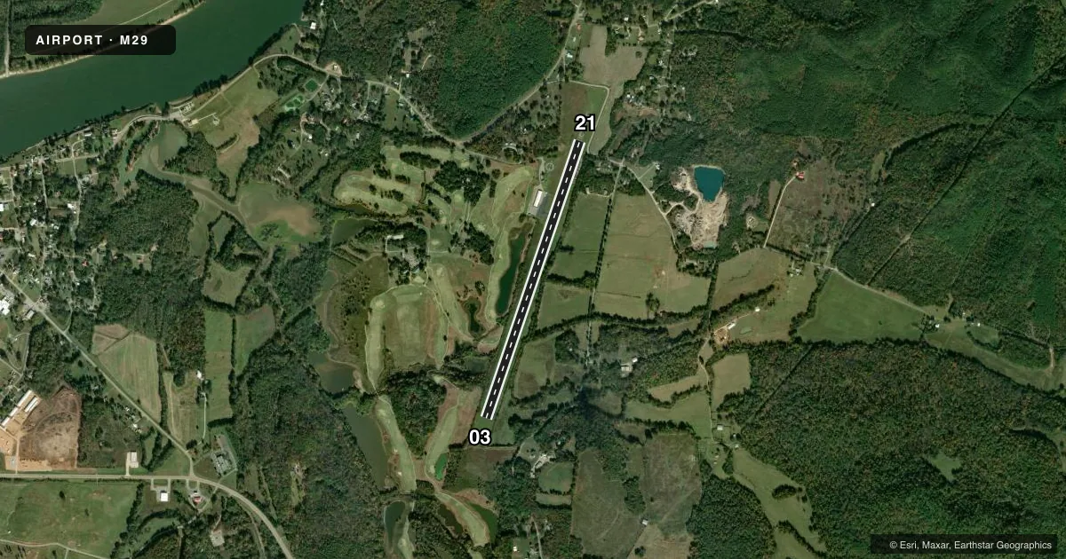
Runways & pattern
Full pagePattern entry · RWY 03
LEFT TRAFFICRunway end performance
| End | TORA | TODA | ASDA | LDA | VGSI | Approach lights | Obstruction |
|---|---|---|---|---|---|---|---|
| 03 | — | — | — | — | — | — | 86', trees, 1920' from thr, 109' R of cntrln, slope 20 |
Declared distances in feet. TORA = takeoff run available, TODA = takeoff distance, ASDA = accelerate-stop, LDA = landing distance.
Airport sketch
Runways drawn to scale from FAA survey coordinates, rendered over satellite imagery. Not for navigation.
Approaches & charts
Services on the field
Fuel grades, oxygen, maintenance, ramp storage and lighting — as declared to the FAA by the airport operator.
Fuel & services
- Fuel
- 100LL
Ramp & ground
- Transient storage
- Tie-down
- Landing fee
- No fee published
- Customs
- Not available
- Wind indicator
- Yes
- Segmented circle
- Yes
Fuel & FBOs
Cheapest 100LL and Jet A on the field and nearby. Always confirm with the FBO before taxi.
Airport notes
Surface conditions, obstructions, local procedures, lighting outages and other notes published with each FAA cycle.
General notes
- FOR CD CTC MEMPHIS ARTCC AT 901-368-8453/8449.
Fuel notes
- 100LLSELF SVC.
Runway surface & condition
- 03/2114 FT RAPIDLY RISING TRRN NE TO 400 FT PAST RWY END SW.
Approach & departure obstructions
- 21APCH RATIO 22:1 TO DTHR.
VFR map & nearby airports
VFR sectional. Tap any ICAO chip to open that airport.
Key facts · M29
Answer card- ICAO
- M29
- Name
- HASSELL FLD
- Location
- CLIFTON, TENNESSEE
- Elevation
- 406.6 ft MSL
- Traffic pattern altitude
- 1,406.6 ft MSL (1,000 AGL)
- Control tower
- Non-towered (use CTAF)
- Total runways
- 1
- Longest runway
- 03/21 · 4,200 ft
- Published ILS approaches
- 0
- Published frequencies
- 1
- Magnetic variation
- 1°
- Current flight rules
- VFR
- Current wind
- 000° at 0 kt
- Favored runway now
- –
Hassell Fld sits near Clifton, Tennessee. The field elevation is 406.6 ft MSL. It has one runway, 03/21, at 4,200 ft asphalt. This is an untowered airport. CTAF is 122.9. No ILS approaches are published here.
The pattern altitude is not published. Use 1,000 ft AGL for light piston operations unless the current Chart Supplement says otherwise. The airport has self-serve 100LL. There are no on-field FBOs listed. Plan to verify services with the airport operator or the FBO directly before you go.
A couple of published remarks matter here. There is rapidly rising terrain northeast of the field near the southwest runway end. The runway 21 approach also has a displaced threshold note with a 22:1 approach ratio. For clearance delivery, Memphis ARTCC is the published contact. If you are planning a first visit, brief the terrain, the runway geometry and the lack of published ILS support before departure. This is a small field with limited published services. Current Chart Supplement data is the item to trust before you launch.