METAR & TAF KSZY
Current METAR
Observed 09:55Z
KSZY 250955Z AUTO 00000KT 10SM CLR 20/19 A3002 RMK A01
- Wind
- 000° @ 0 kt
- Visibility
- 10 SM
- Temp / Dew
- 20°C / 19°C
- Altimeter
- 30.02 inHg
- Clouds
- CLR
- Density alt
- 1,233 ft
- Ceiling
- Unlimited
- Rules
- VFR
Airport info & contacts
Manager on record, flight service, ARTCC, attendance schedule and pattern altitude — published by the FAA and refreshed every 28 days.
Location
- From city
- 5 NM NE
- VFR sectional
- MEMPHIS
- ARTCC
- ZME · MEMPHIS
- NOTAM facility
- MKL (NOTAM-D)
Airport manager
- Name
- CHRIS TULL
- Phone
- 731-645-3014
- Address
- 2282 AIRPORT ROAD, SELMER TN 38375
Flight service · Hours
- FSS MKL
- JACKSON1-800-WX-BRIEF
- Attendance
- SUN · 1000-1500
- MON-FRI · 0800-1700
- SAT · 0900-1600
Frequencies
Tap any row to copy the frequency to your clipboard.
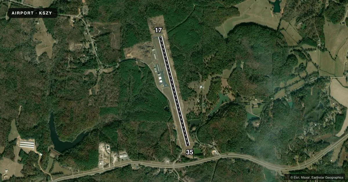
Runways & pattern
Full pagePattern entry · RWY 17
LEFT TRAFFICRunway end performance
| End | TORA | TODA | ASDA | LDA | VGSI | Approach lights | Obstruction |
|---|---|---|---|---|---|---|---|
| 17 | — | — | — | — | PAPI 2-box left(3°) | — | 53', tree, 954' from thr, 218' R of cntrln, slope 14 |
| 35 | — | — | — | — | PAPI 2-box left(4°) | — | 75', tree, 1726' from thr, 468' R of cntrln, slope 20 |
Declared distances in feet. TORA = takeoff run available, TODA = takeoff distance, ASDA = accelerate-stop, LDA = landing distance.
Airport sketch
Runways drawn to scale from FAA survey coordinates, rendered over satellite imagery. Not for navigation.
Approaches & charts
Services on the field
Fuel grades, oxygen, maintenance, ramp storage and lighting — as declared to the FAA by the airport operator.
Fuel & services
- Fuel
- 100LLA+
- Airframe repair
- Major
- Power plant repair
- Major
- Other services
- AMB,AVNCS,INSTR,RNTL
Ramp & ground
- Transient storage
- Tie-down
- Hangar
- Landing fee
- No fee published
- Customs
- Not available
- Lighting schedule
- SEE RMK
- Beacon schedule
- SS-SR
- Beacon
- White / Green (civil land)(WG)
- Wind indicator
- Lighted
- Segmented circle
- No
Fuel & FBOs
Cheapest 100LL and Jet A on the field and nearby. Always confirm with the FBO before taxi.
Airport notes
Surface conditions, obstructions, local procedures, lighting outages and other notes published with each FAA cycle.
General notes
- FOR CD CTC MEMPHIS ARTCC AT 901-368-8453/8449.
Lighting notes
- ACTVT MIRL RWY 17/35 - CTAF.
Other notes
- 3AFT HR - 731-645-3014. CLSD 1600 M-F OCT - MAR.
VFR map & nearby airports
VFR sectional. Tap any ICAO chip to open that airport.
Key facts · KSZY
Answer card- ICAO
- KSZY
- Name
- ROBERT SIBLEY
- Location
- SELMER, TENNESSEE
- Elevation
- 610.2 ft MSL
- Traffic pattern altitude
- 1,610.2 ft MSL (1,000 AGL)
- Control tower
- Non-towered (use CTAF)
- Total runways
- 1
- Longest runway
- 17/35 · 5,002 ft
- Published ILS approaches
- 0
- Published frequencies
- 2
- Magnetic variation
- 1°
- Current flight rules
- VFR
- Current wind
- 000° at 0 kt
- Favored runway now
- –
Robert Sibley Airport sits in Selmer, Tennessee. The field elevation is 610.2 ft MSL. It has one runway, 17/35, which is 5,002 ft long and asphalt. There is no control tower. CTAF and UNICOM are both 122.7. No ILS approaches are published.
Pattern altitude is not published. Use the standard 1,000 ft AGL pattern for light piston traffic unless the current Chart Supplement says otherwise. The runway lights on 17/35 are medium intensity. They are activated by CTAF. That is useful after sunset or on a late arrival. The on-field FBO is Robert Sibley Airport. It carries 100LL, Jet A and Jet A Prist. Call (731) 645-3014 for current service details or after-hours help. Published remarks also say to contact Memphis ARTCC for clearance delivery. The listed numbers are 901-368-8453 and 901-368-8449. The field is a non-towered airport, so expect self-announce traffic and standard see-and-avoid work. Check the current Chart Supplement for any updated local procedures before you go.