METAR & TAF KPVE
Current METAR
Observed 16:55Z
KPVE 261655Z AUTO 23005KT 10SM FEW022 32/26 A3000 RMK A01
- Wind
- 230° @ 5 kt
- Visibility
- 10 SM
- Temp / Dew
- 32°C / 26°C
- Altimeter
- 30.00 inHg
- Clouds
- FEW
- Density alt
- 2,546 ft
- Ceiling
- Unlimited
- Rules
- VFR
Airport info & contacts
Manager on record, flight service, ARTCC, attendance schedule and pattern altitude — published by the FAA and refreshed every 28 days.
Location
- From city
- 5 NM NW
- VFR sectional
- MEMPHIS
- ARTCC
- ZME · MEMPHIS
- NOTAM facility
- MKL (NOTAM-D)
Airport manager
- Name
- KEITH COTTON
- Phone
- 731-845-4937
- Address
- 1600 MT ARARAT ROAD, DARDEN TN 32328
Flight service · Hours
- FSS MKL
- JACKSON1-800-WX-BRIEF
- Attendance
- MON-SAT · 0800-1700
Frequencies
Tap any row to copy the frequency to your clipboard.
Runways & pattern
Full pagePattern entry · RWY 19
LEFT TRAFFICRunway end performance
| End | TORA | TODA | ASDA | LDA | VGSI | Approach lights | Obstruction |
|---|---|---|---|---|---|---|---|
| 01 | — | — | — | — | PAPI 2-box left(3.09°) | — | 26', tree, 975' from thr, 218' R of cntrln, slope 29 |
| 19 | — | — | — | — | PAPI 2-box left(3.29°) | — | — |
Declared distances in feet. TORA = takeoff run available, TODA = takeoff distance, ASDA = accelerate-stop, LDA = landing distance.
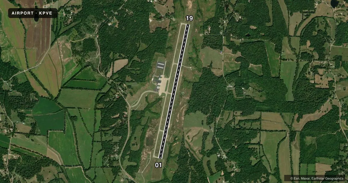
Airport sketch
Runways drawn to scale from FAA survey coordinates, rendered over satellite imagery. Not for navigation.
Approaches & charts
Services on the field
Fuel grades, oxygen, maintenance, ramp storage and lighting — as declared to the FAA by the airport operator.
Fuel & services
- Fuel
- 100LLA+
- Airframe repair
- Major
- Power plant repair
- Major
- Other services
- INSTR
Ramp & ground
- Transient storage
- Tie-down
- Hangar
- Lighting schedule
- SEE RMK
- Beacon schedule
- SS-SR
- Beacon
- White / Green (civil land)(WG)
- Wind indicator
- Lighted
- Segmented circle
- Yes
Fuel & FBOs
Cheapest 100LL and Jet A on the field and nearby. Always confirm with the FBO before taxi.
Airport notes
Surface conditions, obstructions, local procedures, lighting outages and other notes published with each FAA cycle.
General notes
- FOR CD CTC MEMPHIS ARTCC AT 901-368-8453/8449.
Lighting notes
- ACTVT REIL RWY 01 & 19; MIRL RWY 01/19 - CTAF. PAPI RWY 01 & 19 OPR CONSLY.
Fuel notes
- 100LLH24 CREDIT CARD SVC AVBL.
Other notes
- 2CLSD THANKSGIVING, CHRISTMAS, EASTER & NEW YEARS.
- 2AFT HR SVC - AMGR.
VFR map & nearby airports
VFR sectional. Tap any ICAO chip to open that airport.
Key facts · KPVE
Answer card- ICAO
- KPVE
- Name
- BEECH RIVER RGNL
- Location
- LEXINGTON-PARSONS, TENNESSEE
- Elevation
- 487.7 ft MSL
- Traffic pattern altitude
- 1,487.7 ft MSL (1,000 AGL)
- Control tower
- Non-towered (use CTAF)
- Total runways
- 1
- Longest runway
- 01/19 · 6,000 ft
- Published ILS approaches
- 0
- Published frequencies
- 2
- Magnetic variation
- 1°
- Current flight rules
- VFR
- Current wind
- 230° at 5 kt
- Favored runway now
- RWY 19
Beech River Rgnl (KPVE) sits in Lexington-Parsons, Tennessee. Field elevation is 487.7 ft MSL. The airport has one runway. Runway 01/19 is 6,000 ft long with concrete pavement. There is no control tower. CTAF and UNICOM are both 123.0. No ILS approaches are published here.
Pattern altitude is not published. Use the standard 1,000 ft AGL pattern unless local procedures or the current Chart Supplement say otherwise. The field has one on-field FBO, Beech River Regional. It carries AVGAS 100LL and Jet A Prist. 100LL is available 24 hours with credit card service. After-hours service is handled by the airport manager. Runway end identifier lights are active on 01 and 19. Medium intensity runway lights on 01 and 19 are CTAF controlled. Precision approach path indicators on both ends operate continuously.
First-time arrivals should plan for an uncontrolled field with no published ILS. Check the current Chart Supplement before you go. The airport is closed on Thanksgiving, Christmas, Easter and New Year's. For clearance delivery, contact Memphis ARTCC before departure if you need one.