METAR & TAF KHZD
Current METAR
Observed 16:55Z
KHZD 261655Z AUTO 00000KT 6SM HZ FEW019 32/28 A2998 RMK A01
- Wind
- 000° @ 0 kt
- Visibility
- 6 SM
- Temp / Dew
- 32°C / 28°C
- Altimeter
- 29.98 inHg
- Clouds
- FEW
- Density alt
- 2,581 ft
- Ceiling
- Unlimited
- Rules
- VFR
Airport info & contacts
Manager on record, flight service, ARTCC, attendance schedule and pattern altitude — published by the FAA and refreshed every 28 days.
Location
- From city
- 4 NM NW
- VFR sectional
- MEMPHIS
- ARTCC
- ZME · MEMPHIS
- NOTAM facility
- MKL (NOTAM-D)
Airport manager
- Name
- RICHARD DOMINAS
- Phone
- 731-352-7278
- Address
- 535 AIRPORT LANE, MCKENZIE TN 38201
Flight service · Hours
- FSS MKL
- JACKSON1-800-WX-BRIEF
- Attendance
- MON-SAT · 0800-1700
- SUN · 1300-1700
Frequencies
Tap any row to copy the frequency to your clipboard.
Runways & pattern
Full pagePattern entry · RWY 01
LEFT TRAFFICRunway end performance
| End | TORA | TODA | ASDA | LDA | VGSI | Approach lights | Obstruction |
|---|---|---|---|---|---|---|---|
| 01 | — | — | — | — | PAPI 4-box left(3°) | — | 67', tree, 2167' from thr, 458' R of cntrln, slope 29 |
| 19 | — | — | — | — | PAPI 4-box left(4°) | — | 72', tree, 1335' from thr, 329' R of cntrln, slope 15 |
Declared distances in feet. TORA = takeoff run available, TODA = takeoff distance, ASDA = accelerate-stop, LDA = landing distance.
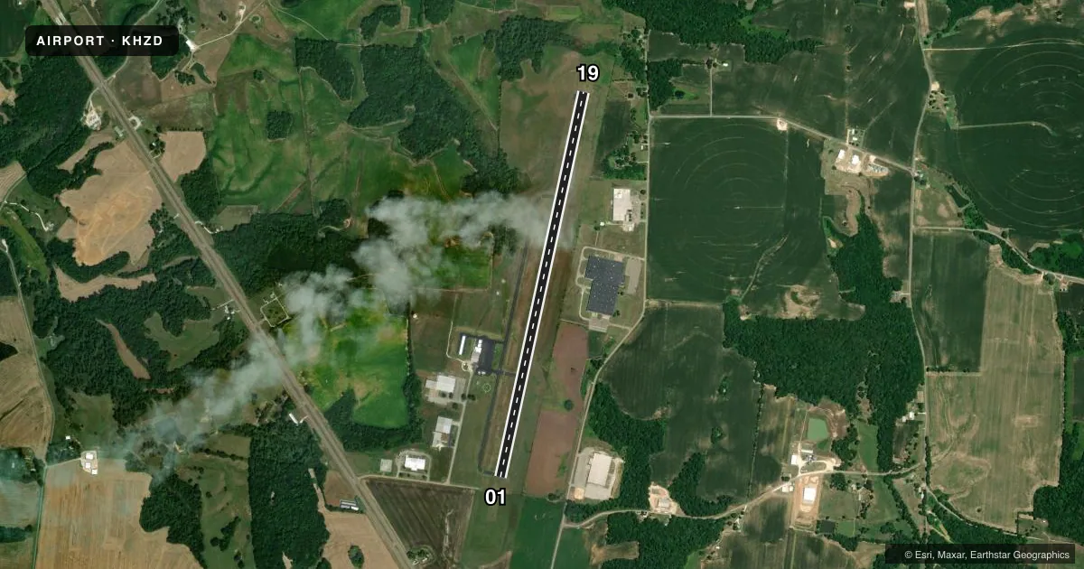
Airport sketch
Runways drawn to scale from FAA survey coordinates, rendered over satellite imagery. Not for navigation.
Approaches & charts
Services on the field
Fuel grades, oxygen, maintenance, ramp storage and lighting — as declared to the FAA by the airport operator.
Fuel & services
- Fuel
- 100LLA+
- Oxygen (bottled)
- Not available
- Oxygen (bulk)
- Not available
- Airframe repair
- Major
- Power plant repair
- Major
- Other services
- INSTR,RNTL,SALES
Ramp & ground
- Transient storage
- Tie-down
- Hangar
- Lighting schedule
- SEE RMK
- Beacon schedule
- SS-SR
- Beacon
- White / Green (civil land)(WG)
- Wind indicator
- Lighted
- Segmented circle
- Yes
Fuel & FBOs
Cheapest 100LL and Jet A on the field and nearby. Always confirm with the FBO before taxi.
Airport notes
Surface conditions, obstructions, local procedures, lighting outages and other notes published with each FAA cycle.
General notes
- FOR CD CTC MEMPHIS ARTCC AT 901-368-8453/8449.
Lighting notes
- ACTVT REIL RWY 01 & 19; PAPI RWY 01 & 19; MIRL RWY 01/19 - CTAF. MIRL RWY 01/19 PRESET MED INTST; INCR INTST - CTAF.
Approach & departure obstructions
- 01PAPI UNUSBL BYD 9 DEGS RIGHT OF CNTRLN.
- 19PAPI UNUSBL BYD 9 DEGS LEFT AND 8 DEGS RIGHT OF CNTRLN.
Other notes
- PRVDD VFR ONLY.
- 1AFT HR - 731-641-0123.
VFR map & nearby airports
VFR sectional. Tap any ICAO chip to open that airport.
Key facts · KHZD
Answer card- ICAO
- KHZD
- Name
- SGT LEE RUSSELL CARROLL COUNTY
- Location
- HUNTINGDON, TENNESSEE
- Elevation
- 496.6 ft MSL
- Traffic pattern altitude
- 1,496.6 ft MSL (1,000 AGL)
- Control tower
- Non-towered (use CTAF)
- Total runways
- 1
- Longest runway
- 01/19 · 5,507 ft
- Published ILS approaches
- 0
- Published frequencies
- 2
- Magnetic variation
- 2°
- Current flight rules
- VFR
- Current wind
- 000° at 0 kt
- Favored runway now
- –
SGT LEE RUSSELL CARROLL COUNTY (KHZD) sits in Huntingdon, Tennessee. Field elevation is 496.6 ft MSL. The airport has one runway. Runway 01/19 is 5,507 ft long with an asphalt surface. There is no control tower. CTAF and UNICOM are both 122.8. No ILS approaches are published here.
Pattern altitude is not published. Use the standard 1,000 ft AGL pattern for light piston aircraft unless the current Chart Supplement says otherwise. The field is a good fit for VFR planning, but the published remarks matter. Runway lights on 01/19 are medium intensity and are controlled by CTAF. The approach lighting system with runway end identifier lights is active on both ends. The PAPI on runway 01 is unusable beyond 9 degrees right of centerline. The PAPI on runway 19 is unusable beyond 9 degrees left of centerline. It is also unusable beyond 8 degrees right of centerline.
Swor Aviation is on the field. It carries 100LL and Jet A Prist. For clearance delivery, Memphis ARTCC is listed in the remarks. After hours contact is 731-641-0123. If you are planning a night arrival or a first visit, review the lighting notes and call the FBO directly before you go.