METAR & TAF KUCY
Current METAR
Observed 12:55Z
KUCY 271255Z AUTO 22004KT 10SM CLR 23/23 A2993 RMK A01
- Wind
- 220° @ 4 kt
- Visibility
- 10 SM
- Temp / Dew
- 23°C / 23°C
- Altimeter
- 29.93 inHg
- Clouds
- CLR
- Density alt
- 1,376 ft
- Ceiling
- Unlimited
- Rules
- VFR
Airport info & contacts
Manager on record, flight service, ARTCC, attendance schedule and pattern altitude — published by the FAA and refreshed every 28 days.
Location
- From city
- 4 NM SE
- VFR sectional
- ST LOUIS
- ARTCC
- ZME · MEMPHIS
- NOTAM facility
- MKL (NOTAM-D)
Airport manager
- Name
- DON COADY
- Phone
- 731-885-1221
- Address
- 1489 AIRPORT CIRCLE, UNION CITY TN 38261
Flight service · Hours
- FSS MKL
- JACKSON1-800-WX-BRIEF
- Attendance
- MON-SAT · 0730-1700
- SUN · 1230-1700
Frequencies
Tap any row to copy the frequency to your clipboard.
Runways & pattern
Full pagePattern entry · RWY 19
LEFT TRAFFICRunway end performance
| End | TORA | TODA | ASDA | LDA | VGSI | Approach lights | Obstruction |
|---|---|---|---|---|---|---|---|
| 01 | — | — | — | — | PAPI 4-box left(3°) | ODALS | — |
| 19 | — | — | — | — | PAPI 4-box left(3°) | — | 75', pline, 3450' from thr, 0' R of cntrln, slope 43 |
Declared distances in feet. TORA = takeoff run available, TODA = takeoff distance, ASDA = accelerate-stop, LDA = landing distance.
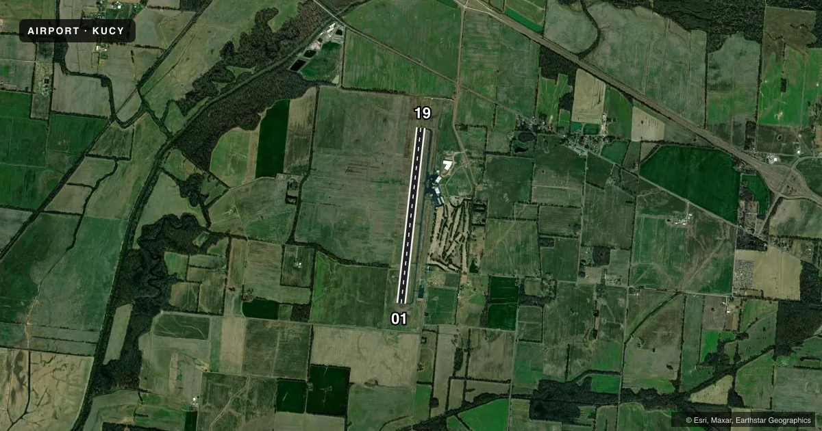
Airport sketch
Runways drawn to scale from FAA survey coordinates, rendered over satellite imagery. Not for navigation.
Approaches & charts
ILS · 1
Services on the field
Fuel grades, oxygen, maintenance, ramp storage and lighting — as declared to the FAA by the airport operator.
Fuel & services
- Fuel
- 100LLA+
- Oxygen (bottled)
- HIGH/LOW
- Oxygen (bulk)
- HIGH/LOW
- Airframe repair
- Major
- Power plant repair
- Major
- Other services
- AGRI,CHTR,INSTR,RNTL
Ramp & ground
- Transient storage
- Tie-down
- Hangar
- Landing fee
- No fee published
- Customs
- Not available
- Lighting schedule
- SEE RMK
- Beacon schedule
- SS-SR
- Beacon
- White / Green (civil land)(WG)
- Wind indicator
- Lighted
- Segmented circle
- Yes
Fuel & FBOs
Cheapest 100LL and Jet A on the field and nearby. Always confirm with the FBO before taxi.
Airport notes
Surface conditions, obstructions, local procedures, lighting outages and other notes published with each FAA cycle.
General notes
- AEROBATIC ACT INVOF ARPT.
- FOR CD CTC MEMPHIS ARTCC AT 901-368-8453/8449.
Lighting notes
- ACTVT ODALS RWY 01 - CTAF. PAPI RWY 01 & 19 OPR CONSLY.
Approach & departure obstructions
- 01R TFC WHEN AEROBATIC AREA ACTIVE.
- 01ROAD 1040 FT S OF THR; XS L TO R.
VFR map & nearby airports
VFR sectional. Tap any ICAO chip to open that airport.
Key facts · KUCY
Answer card- ICAO
- KUCY
- Name
- EVERETT-STEWART RGNL
- Location
- UNION CITY, TENNESSEE
- Elevation
- 345.6 ft MSL
- Traffic pattern altitude
- 1,345.6 ft MSL (1,000 AGL)
- Control tower
- Non-towered (use CTAF)
- Total runways
- 1
- Longest runway
- 01/19 · 6,503 ft
- Published ILS approaches
- 1
- Published frequencies
- 2
- Magnetic variation
- 0°
- Current flight rules
- VFR
- Current wind
- 220° at 4 kt
- Favored runway now
- RWY 19
Everett-Stewart Rgnl sits in Union City, Tennessee. Field elevation is 345.6 ft MSL. The airport has one runway, 01/19. The longest runway is 6,503 ft. There is no control tower. CTAF and UNICOM are both 122.7. One ILS approach is published for runway 01. Pattern altitude is not published, so use the standard 1,000 ft AGL for light piston traffic unless the current Chart Supplement says otherwise.
The on-field FBO is Everett-Stewart Regional Airport. It carries 100LL and Jet A Prist. Call (731) 885-1221 before arrival if you need current ramp or service details. Published remarks matter here. A road sits 1,040 ft south of the runway 01 threshold. The approach lighting for runway 01 is activated on CTAF. The PAPI for runways 01 and 19 runs continuously. Aerobatic activity also occurs near the airport. When that area is active, right traffic is used for runway 01. For clearance delivery, Memphis ARTCC handles it by phone. This is a field where a quick read of the current Chart Supplement is smart before you launch. That is especially true if you are planning a night arrival or an approach to 01.