METAR & TAF M25
Current METAR
Observed 19:55Z
KM25 261955Z AUTO 28005KT 10SM SCT042 SCT280 BKN330 BKN350 34/28 A2993 RMK AO2 T03430279
- Wind
- 280° @ 5 kt
- Visibility
- 10 SM
- Temp / Dew
- 34°C / 28°C
- Altimeter
- 29.93 inHg
- Clouds
- BKN
- Density alt
- 2,915 ft
- Ceiling
- 33,000 ft AGL
- Rules
- VFR
Airport info & contacts
Manager on record, flight service, ARTCC, attendance schedule and pattern altitude — published by the FAA and refreshed every 28 days.
Location
- From city
- 3 NM NE
- VFR sectional
- ST LOUIS
- ARTCC
- ZME · MEMPHIS
- NOTAM facility
- LOU (NOTAM-D)
Airport manager
- Name
- BRENT ROBERTSON
- Phone
- 270-247-6878
- Address
- 227 AIRPORT ROAD, MAYFIELD KY 42066
Flight service · Hours
- FSS LOU
- LOUISVILLE1-800-WX-BRIEF
- Attendance
- 0700-1500
Frequencies
Tap any row to copy the frequency to your clipboard.
Runways & pattern
Full pagePattern entry · RWY 01
LEFT TRAFFICRunway end performance
| End | TORA | TODA | ASDA | LDA | VGSI | Approach lights | Obstruction |
|---|---|---|---|---|---|---|---|
| 01 | — | — | — | — | PAPI 2-box left(3°) | — | 31', trees, 756' from thr, 144' R of cntrln, slope 17 |
| 19 | — | — | — | — | PAPI 4-box left(3°) | — | 57', tree, 1722' from thr, 428' R of cntrln, slope 26 |
Declared distances in feet. TORA = takeoff run available, TODA = takeoff distance, ASDA = accelerate-stop, LDA = landing distance.
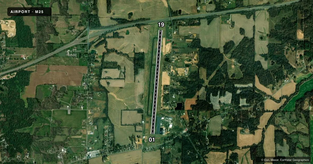
Airport sketch
Runways drawn to scale from FAA survey coordinates, rendered over satellite imagery. Not for navigation.
Approaches & charts
Services on the field
Fuel grades, oxygen, maintenance, ramp storage and lighting — as declared to the FAA by the airport operator.
Fuel & services
- Fuel
- 100LLA+
- Oxygen (bottled)
- Low pressure
- Airframe repair
- Minor
- Power plant repair
- Major
- Other services
- INSTR,RNTL
Ramp & ground
- Transient storage
- Tie-down
- Hangar
- Landing fee
- No fee published
- Customs
- Not available
- Lighting schedule
- SEE RMK
- Beacon schedule
- SS-SR
- Beacon
- White / Green (civil land)(WG)
- Wind indicator
- Lighted
- Segmented circle
- Yes
Fuel & FBOs
Cheapest 100LL and Jet A on the field and nearby. Always confirm with the FBO before taxi.
Airport notes
Surface conditions, obstructions, local procedures, lighting outages and other notes published with each FAA cycle.
General notes
- FOR CD CTC MEMPHIS ARTCC AT 901-368-8453/8449.
Lighting notes
- REIL RWY 01 & 19; PAPI RWY 01 & 19; MIRL RWY 01/19 OPR DUSK-DAWN & ACTVT REIL RWY 01 & 19; PAPI RWY 01 & 19; MIRL RWY 01/19 CTAF.
Fuel notes
- 100LLAVBL H24 WITH CREDIT CARD.
Other notes
- EXISTED PRIOR TO 1959.
- OWNERTODD MCBEE - 270-519-5586.
VFR map & nearby airports
VFR sectional. Tap any ICAO chip to open that airport.
Key facts · M25
Answer card- ICAO
- M25
- Name
- MAYFIELD GRAVES COUNTY
- Location
- MAYFIELD, KENTUCKY
- Elevation
- 522.4 ft MSL
- Traffic pattern altitude
- 1,522.4 ft MSL (1,000 AGL)
- Control tower
- Non-towered (use CTAF)
- Total runways
- 1
- Longest runway
- 01/19 · 5,002 ft
- Published ILS approaches
- 0
- Published frequencies
- 2
- Magnetic variation
- 2°
- Current flight rules
- VFR
- Current wind
- 280° at 5 kt
- Favored runway now
- RWY 01
Mayfield Graves County Airport sits in Mayfield, Kentucky. The field elevation is 522.4 ft MSL. It has one runway, 01/19, which is 5,002 ft long and asphalt. There is no control tower. CTAF and UNICOM are both 122.8. No ILS approaches are published here.
The published pattern altitude is not listed, so use the standard 1,000 ft AGL for light piston aircraft unless the current Chart Supplement says otherwise. Runway 01 and runway 19 both have faded markings with algae noted in the remarks. That is worth a close look on rollout and during the takeoff brief. The runway end identifier lights, PAPI and medium intensity runway lights are installed on 01/19. The lights are activated by CTAF. Medium intensity runway lights operate from dusk to dawn.
Mayfield-Graves County Airport is the on-field FBO. It carries 100LL and Jet A. 100LL is available 24 hours with credit card. For clearance delivery, the remarks direct pilots to Memphis ARTCC. This is a non-towered field, so keep your radio calls tight and watch the pattern closely. The airport sits in western Kentucky at low elevation, so density altitude is usually less of a factor than runway condition and traffic awareness. Check the current FAA Chart Supplement for any published restrictions before you go.