METAR & TAF M34
M34 does not publish a METAR.
Showing the nearest reporting station: KCEY (KYLE-OAKLEY FLD) · 21.0 NM away. Conditions at M34 may differ.
METAR · KCEY
Observed 06:15Z
KCEY 270615Z AUTO 22003KT 10SM CLR 23/23 A2994 RMK AO2
- Wind
- 220° @ 3 kt
- Visibility
- 10 SM
- Temp / Dew
- 23°C / 23°C
- Altimeter
- 29.94 inHg
- Clouds
- CLR
- Density alt
- 1,370 ft
- Ceiling
- Unlimited
- Rules
- VFR
Airport info & contacts
Manager on record, flight service, ARTCC, attendance schedule and pattern altitude — published by the FAA and refreshed every 28 days.
Location
- From city
- 3 NM SE
- VFR sectional
- ST LOUIS
- ARTCC
- ZME · MEMPHIS
- NOTAM facility
- LOU (NOTAM-D)
Airport manager
- Name
- JOHN WARD
- Phone
- (270) 395-7138
- Address
- P.O. BOX 36, CALVERT CITY KY 42029
Flight service · Hours
- FSS LOU
- LOUISVILLE1-800-WX-BRIEF
- Attendance
- Unattended
Frequencies
Tap any row to copy the frequency to your clipboard.
Runways & pattern
Full pagePattern entry · RWY 28
LEFT TRAFFICRunway end performance
| End | TORA | TODA | ASDA | LDA | VGSI | Approach lights | Obstruction |
|---|---|---|---|---|---|---|---|
| 10 | — | — | — | — | PAPI 2-box left(4°) | — | — |
| 28 | — | — | — | — | PAPI 2-box left(4°) | — | 68', trees, 594' from thr, 276' R of cntrln, slope 5 |
Declared distances in feet. TORA = takeoff run available, TODA = takeoff distance, ASDA = accelerate-stop, LDA = landing distance.
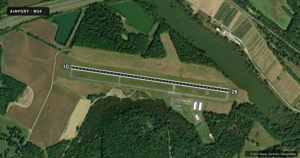
Airport sketch
Runways drawn to scale from FAA survey coordinates, rendered over satellite imagery. Not for navigation.
Approaches & charts
Services on the field
Fuel grades, oxygen, maintenance, ramp storage and lighting — as declared to the FAA by the airport operator.
Fuel & services
- Fuel
- 100LLA
Ramp & ground
- Transient storage
- Tie-down
- Landing fee
- No fee published
- Customs
- Not available
- Lighting schedule
- SEE RMK
- Beacon schedule
- SS-SR
- Beacon
- White / Green (civil land)(WG)
- Wind indicator
- Lighted
- Segmented circle
- Yes
Fuel & FBOs
Cheapest 100LL and Jet A on the field and nearby. Always confirm with the FBO before taxi.
Airport notes
Surface conditions, obstructions, local procedures, lighting outages and other notes published with each FAA cycle.
General notes
- DEER & GEESE ON & INVOF ARPT.
- FOR CD CTC MEMPHIS ARTCC AT 901-368-8453/8449.
Lighting notes
- ACTVT REIL RWY 10 & 28; PAPI RWY 10 & 28; MIRL RWY 10/28 - CTAF.
Other notes
- EXISTED PRIOR TO 1959.
VFR map & nearby airports
VFR sectional. Tap any ICAO chip to open that airport.
Key facts · M34
Answer card- ICAO
- M34
- Name
- KENTUCKY DAM STATE PARK
- Location
- CALVERT CITY, KENTUCKY
- Elevation
- 350.8 ft MSL
- Traffic pattern altitude
- 1,350.8 ft MSL (1,000 AGL)
- Control tower
- Non-towered (use CTAF)
- Total runways
- 1
- Longest runway
- 10/28 · 3,997 ft
- Published ILS approaches
- 0
- Published frequencies
- 2
- Magnetic variation
- 3°
- Current flight rules
- VFR
- Current wind
- 220° at 3 kt
- Favored runway now
- RWY 28
Kentucky Dam State Park Airport is in Calvert City, Kentucky. The field elevation is 350.8 ft MSL. It has one runway. Runway 10/28 is 3,997 ft long with asphalt pavement. The airport is not towered. CTAF and UNICOM are both 123.0. No ILS approaches are published here.
Pattern altitude is not published. Use 1,000 ft AGL as the standard light-piston pattern reference unless the current Chart Supplement says otherwise. The published remarks call out deer and geese on and near the airport. That matters here. Keep a sharp scan on departure and in the pattern. Runway end identifier lights are active on both ends. PAPI is installed on 10 and 28. Medium intensity runway lights are on runway 10/28 and are controlled by CTAF.
There are no on-field FBOs listed, so plan ahead for services before you go. For clearance delivery, Memphis ARTCC is the published contact. If you are arriving IFR or need current airport details, check the current FAA Chart Supplement or call the airport operator directly before flight. The field sits in a low-elevation part of western Kentucky, so terrain is not the main issue. Wildlife and runway lighting setup are the bigger items to brief.