METAR & TAF KPAH
Current METAR
Observed 20:53Z
KPAH 262053Z 26007KT 230V310 10SM FEW035 34/27 A2990 RMK AO2 SLP117 T03440272 58016 $
- Wind
- 260° @ 7 kt
- Visibility
- 10 SM
- Temp / Dew
- 34°C / 27°C
- Altimeter
- 29.90 inHg
- Clouds
- FEW
- Density alt
- 2,814 ft
- Ceiling
- Unlimited
- Rules
- VFR
Airport info & contacts
Manager on record, flight service, ARTCC, attendance schedule and pattern altitude — published by the FAA and refreshed every 28 days.
Location
- From city
- 9 NM W
- VFR sectional
- ST LOUIS
- ARTCC
- ZME · MEMPHIS
- NOTAM facility
- PAH (NOTAM-D)
Airport manager
- Name
- DENNIS ROULEAU
- Phone
- 270-744-0521
- Address
- 100 TERMINAL DRIVE, WEST PADUCAH KY 42086-1131
Flight service · Hours
- FSS LOU
- LOUISVILLE1-800-WX-BRIEF
- Attendance
- 0500-1800
Frequencies
Tap any row to copy the frequency to your clipboard.
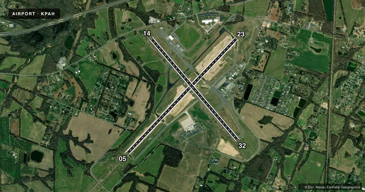
Runways & pattern
Full pagePattern entry · RWY 23
LEFT TRAFFIC| Runway | Heading (°M) | Length | Surface | Traffic |
|---|---|---|---|---|
| 05/23Favored | 43° / 223° | 6,500 ft | ASPH | Standard L |
| 14/32 | 138° / 318° | 5,499 ft | ASPH | Standard L |
Runway end performance
| End | TORA | TODA | ASDA | LDA | VGSI | Approach lights | Obstruction |
|---|---|---|---|---|---|---|---|
| 05 | 6,500' | 6,500' | 6,500' | 6,500' | — | MALSR | 37', pole, 1600' from thr, 312' R of cntrln, slope 37 |
| 23 | 6,500' | 6,500' | 6,500' | 6,500' | PAPI 4-box left(3°) | — | 28', trees, 1000' from thr, 500' R of cntrln, slope 28 |
| 14 | 5,499' | 5,499' | 5,499' | 5,399' | — | — | 26', tree, 900' from thr, 200' R of cntrln, slope 26 |
| 32 | 5,499' | 5,499' | 5,324' | 5,324' | PAPI 4-box left(3°) | — | 71', trees, 1175' from thr, 390' R of cntrln, slope 13 |
Declared distances in feet. TORA = takeoff run available, TODA = takeoff distance, ASDA = accelerate-stop, LDA = landing distance.
Airport sketch
Runways drawn to scale from FAA survey coordinates, rendered over satellite imagery. Not for navigation.
Approaches & charts
ILS · 1
Services on the field
Fuel grades, oxygen, maintenance, ramp storage and lighting — as declared to the FAA by the airport operator.
Fuel & services
- Fuel
- 100LLA
- Oxygen (bottled)
- High pressure
- Airframe repair
- Major
- Power plant repair
- Major
- Other services
- AVNCS
Ramp & ground
- Transient storage
- Tie-down
- Hangar
- Landing fee
- No fee published
- Customs
- Not available
- Lighting schedule
- SEE RMK
- Beacon schedule
- SS-SR
- Beacon
- White / Green (civil land)(WG)
- Wind indicator
- Lighted
- Segmented circle
- Yes
Fuel & FBOs
Cheapest 100LL and Jet A on the field and nearby. Always confirm with the FBO before taxi.
Airport notes
Surface conditions, obstructions, local procedures, lighting outages and other notes published with each FAA cycle.
General notes
- NWS ON ARPT - 270-744-6440.
- SFC COND NOT MNTD 0600-1800. WET SFC COND NOT RPRTD.
- FOR CD CTC MEMPHIS ARTCC AT 901-368-8453/8449.
- ARPT MNTNS INDEX A; INDEX B AVBL UPON REQ .
Lighting notes
- WHEN ATCT CLSD ACTVT MALSR RWY 05; REIL RWY 23 & 32; PAPI RWY 23 &32; HIRL RWY 05/23; MIRL RWY 14/32; TWY LGTS; LGTD WIND CONE - CTAF.
Runway surface & condition
- 05/23PCR VALUE: 860/F/B/X/T
- 14/32PCR VALUE: 550/F/D/X/T
- 05/23ACFT OPS NOT VSB FM OPPOSITE RWY ENDS DUE TO GRADE.
Other notes
- EXISTED PRIOR TO 1959.
- ACR OPS WITH MORE THAN 30 PAX SEATS 24 HR PPR - 270-744-0521.
VFR map & nearby airports
VFR sectional. Tap any ICAO chip to open that airport.
Key facts · KPAH
Answer card- ICAO
- KPAH
- Name
- BARKLEY RGNL
- Location
- PADUCAH, KENTUCKY
- Elevation
- 410.4 ft MSL
- Traffic pattern altitude
- 1,410.4 ft MSL (1,000 AGL)
- Control tower
- Towered · 0600-2300
- Total runways
- 2
- Longest runway
- 05/23 · 6,500 ft
- Published ILS approaches
- 1
- Published frequencies
- 6
- Magnetic variation
- 1°
- Current flight rules
- VFR
- Current wind
- 260° at 7 kt
- Favored runway now
- RWY 23
Barkley Rgnl sits in Paducah, Kentucky. The field elevation is 410.4 ft MSL. It has 2 asphalt runways. The longest is runway 05/23 at 6,500 ft. The tower is open 0600 to 2300. Runway 05 has the ILS approach. Pattern altitude is not published in the facts, so use the standard 1,000 ft AGL for light piston traffic unless ATC or the Chart Supplement says otherwise.
Four Rivers Aviation is on the field. It carries 100LL and Jet A with Prist. If you are planning a stop, that is the confirmed fuel option in the facts. The airport remarks also note that surface condition is not maintained from 0600 to 1800. Wet surface condition is not reported. That matters on a quick turn or after rain. When the tower is closed, the lighting setup includes the approach lights for runway 05, runway end identifier lights for 23 and 32, PAPI for 23 and 32, high intensity lights on 05/23, medium intensity lights on 14/32, taxiway lights and a lighted wind cone on CTAF.
For a first-time arrival, pay attention to the runway layout and the grade on 05/23. Operations are not visible from the opposite runway ends because of the grade. Clearance delivery is handled through Memphis Center. Check the current Chart Supplement for any noise or operational details before you go.