METAR & TAF M30
Current METAR
Observed 12:55Z
KM30 271255Z AUTO 23003KT 10SM CLR 22/22 A2994 RMK AO2 T02200216
- Wind
- 230° @ 3 kt
- Visibility
- 10 SM
- Temp / Dew
- 22°C / 22°C
- Altimeter
- 29.94 inHg
- Clouds
- CLR
- Density alt
- 1,292 ft
- Ceiling
- Unlimited
- Rules
- VFR
Airport info & contacts
Manager on record, flight service, ARTCC, attendance schedule and pattern altitude — published by the FAA and refreshed every 28 days.
Location
- From city
- 2 NM NW
- VFR sectional
- ST LOUIS
- ARTCC
- ZME · MEMPHIS
- NOTAM facility
- M30 (NOTAM-D)
Airport manager
- Name
- WAYNE HELM
- Phone
- 618-524-6765
- Address
- 751 AIRPORT RD, METROPOLIS IL 62960
Flight service · Hours
- FSS STL
- SAINT LOUIS1-800-WX-BRIEF
- Attendance
- IRREG
Frequencies
Tap any row to copy the frequency to your clipboard.
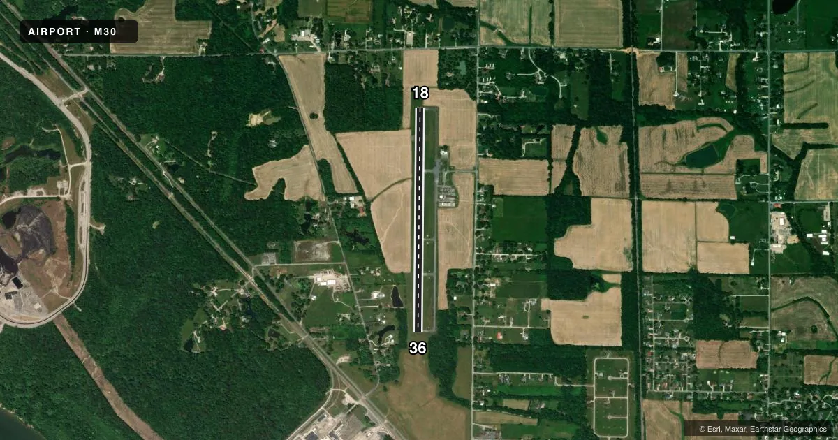
Runways & pattern
Full pagePattern entry · RWY 18
LEFT TRAFFICAirport sketch
Runways drawn to scale from FAA survey coordinates, rendered over satellite imagery. Not for navigation.
Approaches & charts
Services on the field
Fuel grades, oxygen, maintenance, ramp storage and lighting — as declared to the FAA by the airport operator.
Fuel & services
- Fuel
- 100LL
- Oxygen (bottled)
- Not available
- Oxygen (bulk)
- Not available
- Airframe repair
- Not available
- Power plant repair
- Not available
- Other services
- AGRI,INSTR,RNTL,SALES
Ramp & ground
- Transient storage
- Tie-down
- Hangar
- Landing fee
- No fee published
- Customs
- Not available
- Lighting schedule
- SS-SR
- Beacon schedule
- SS-SR
- Beacon
- White / Green (civil land)(WG)
- Wind indicator
- Lighted
- Segmented circle
- No
Fuel & FBOs
Cheapest 100LL and Jet A on the field and nearby. Always confirm with the FBO before taxi.
Airport notes
Surface conditions, obstructions, local procedures, lighting outages and other notes published with each FAA cycle.
General notes
- AVOID FACTORY LCTD 4000 FT SW OF RY 18/36.
- FOR CD CTC MEMPHIS ARTCC AT 901-368-8453/8449.
Fuel notes
- 100LLSELF SVC FUEL AVBL 24 HRS WITH CREDIT CARD.
Other notes
- EXISTED PRIOR TO 1959.
- MANAGEREMAIL: METROPOLISMUNICIPALAIRPORT@GMAIL.COM
VFR map & nearby airports
VFR sectional. Tap any ICAO chip to open that airport.
Key facts · M30
Answer card- ICAO
- M30
- Name
- METROPOLIS MUNI
- Location
- METROPOLIS, ILLINOIS
- Elevation
- 384.3 ft MSL
- Traffic pattern altitude
- 1,384.3 ft MSL (1,000 AGL)
- Control tower
- Non-towered (use CTAF)
- Total runways
- 1
- Longest runway
- 18/36 · 4,002 ft
- Published ILS approaches
- 0
- Published frequencies
- 2
- Magnetic variation
- 1°
- Current flight rules
- VFR
- Current wind
- 230° at 3 kt
- Favored runway now
- RWY 18
Metropolis Muni sits in Metropolis, Illinois. The field elevation is 384.3 ft MSL. It has one runway, 18/36, at 4,002 ft of asphalt. There is no control tower. CTAF and UNICOM are both 122.8. No ILS approaches are published here.
The pattern altitude is not published. Use the standard 1,000 ft AGL for light piston traffic unless the current Chart Supplement says otherwise. The on-field FBO is Metropolis Municipal Airport. It carries AVGAS 100LL. Self-service fuel is available 24 hours with credit card. The airport also notes a factory about 4,000 ft southwest of runway 18/36, so plan your departure and arrival path with that in mind.
This is a non-towered field, so expect self-announce traffic and standard see-and-avoid work. The airport is in Metropolis, which is in southern Illinois near the Kentucky border. If you need IFR clearance, contact Memphis ARTCC using the published numbers before departure. For any current noise, operating, or airport-use details, verify with the current FAA Chart Supplement or call the airport operator directly.