METAR & TAF KMWA
Current METAR
Observed 18:45Z
KMWA 261845Z 23008KT 10SM BKN050 34/26 A2993
- Wind
- 230° @ 8 kt
- Visibility
- 10 SM
- Temp / Dew
- 34°C / 26°C
- Altimeter
- 29.93 inHg
- Clouds
- BKN
- Density alt
- 2,853 ft
- Ceiling
- 5,000 ft AGL
- Rules
- VFR
Airport info & contacts
Manager on record, flight service, ARTCC, attendance schedule and pattern altitude — published by the FAA and refreshed every 28 days.
Location
- From city
- 4 NM W
- VFR sectional
- ST LOUIS
- ARTCC
- ZKC · KANSAS CITY
- NOTAM facility
- MWA (NOTAM-D)
Airport manager
- Name
- DOUGLAS S KIMMEL
- Phone
- 618-993-3353
- Address
- 10400 TERMINAL DR; SUITE 200, MARION IL 62959
Flight service · Hours
- FSS STL
- SAINT LOUIS1-800-WX-BRIEF
- Attendance
- ALL
Frequencies
Tap any row to copy the frequency to your clipboard.
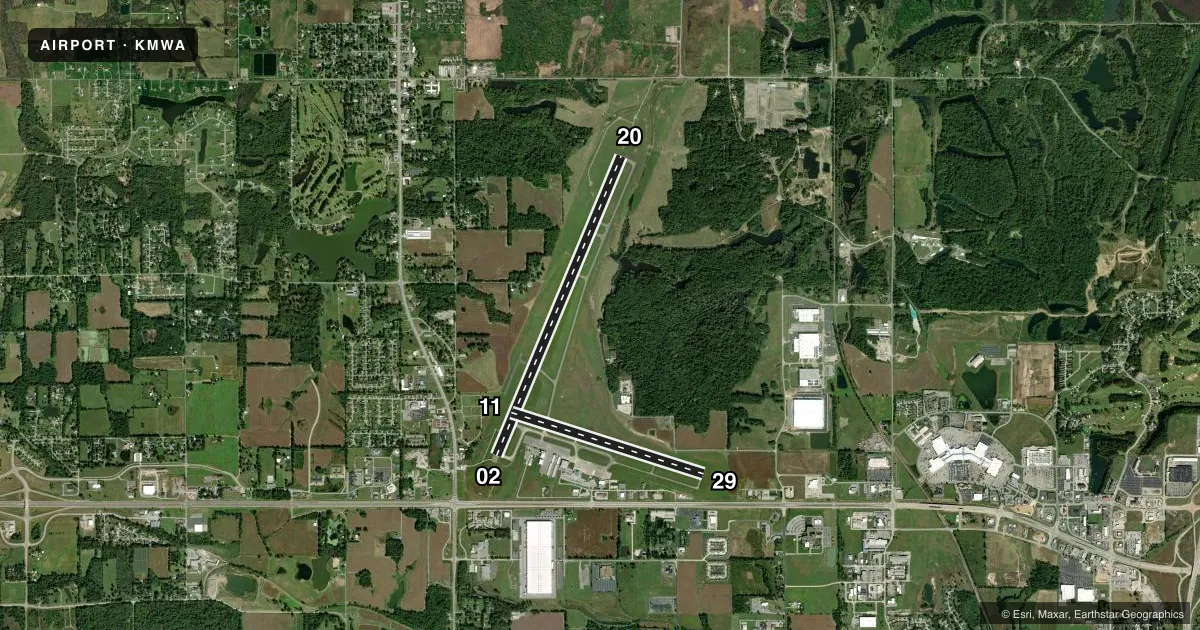
Runways & pattern
Full pagePattern entry · RWY 20
LEFT TRAFFIC| Runway | Heading (°M) | Length | Surface | Traffic |
|---|---|---|---|---|
| 02/20Favored | 21° / 201° | 8,012 ft | ASPH | Standard L |
| 11/29 | 107° / 287° | 4,997 ft | ASPH-CONC | Standard L |
Runway end performance
| End | TORA | TODA | ASDA | LDA | VGSI | Approach lights | Obstruction |
|---|---|---|---|---|---|---|---|
| 02 | 8,012' | 8,012' | 8,012' | 8,012' | PAPI 4-box left(3.5°) | — | 56', trees, 2130' from thr, 697' R of cntrln, slope 34 |
| 20 | 8,012' | 8,012' | 8,012' | 8,012' | — | MALSR | 83', tree, 2945' from thr, 847' R of cntrln, slope 33 |
| 11 | 4,997' | 4,997' | 4,997' | 4,997' | PAPI 4-box left(3°) | — | 62', tree, 1537' from thr, 90' R of cntrln, slope 21 |
| 29 | 4,997' | 4,997' | 4,997' | 4,997' | PAPI 4-box left(3°) | — | 30', sign, 1218' from thr, 249' R of cntrln, slope 33 |
Declared distances in feet. TORA = takeoff run available, TODA = takeoff distance, ASDA = accelerate-stop, LDA = landing distance.
Airport sketch
Runways drawn to scale from FAA survey coordinates, rendered over satellite imagery. Not for navigation.
Approaches & charts
ILS · 1
Services on the field
Fuel grades, oxygen, maintenance, ramp storage and lighting — as declared to the FAA by the airport operator.
Fuel & services
- Fuel
- 100LLA
- Oxygen (bottled)
- Not available
- Oxygen (bulk)
- Not available
- Airframe repair
- Major
- Power plant repair
- Major
- Other services
- CARGO,CHTR,INSTR,RNTL,SALES
Ramp & ground
- Transient storage
- Hangar
- Landing fee
- No fee published
- Customs
- Not available
- Lighting schedule
- SEE RMK
- Beacon schedule
- SS-SR
- Beacon
- White / Green (civil land)(WG)
- Wind indicator
- Lighted
- Segmented circle
- Yes
Fuel & FBOs
Cheapest 100LL and Jet A on the field and nearby. Always confirm with the FBO before taxi.
Airport notes
Surface conditions, obstructions, local procedures, lighting outages and other notes published with each FAA cycle.
General notes
- WATERFOWL & DEER ON & INVOF ARPT.
- TWY E & E4 CLSD INDEF.
- HELIPADS ARE LOCATED IN THE NE CORNER OF GA RAMP. HELIPADS ARE IN NON-MOVEMENT AREA.
Lighting notes
- ACTVT MALSR RWY 20; REIL RWY 11 & 29; PAPI RWY 02, 11 & 29; HIRL RWY 02/20; MIRL RWY 11/29 - CTAF. HIRL RWY 02/20 PRESET TO LOW INTST; INCR INTST - CTAF.
Runway surface & condition
- 02/20PCR VALUE: 550/F/D/X/T
- 11/29PCR VALUE: 190/R/D/W/T
- 11/29FIRST 1200 FT OF RWY 29 GRVD CONC.
Other notes
- 72 HR PPR RQR FOR UNSKED ACR OPS WITH MORE THAN 30 PAX SEATS - CTC AMGR.
- 1SVC AVBL 0700-1800; AFT HR - 618-993-2764.
- MANAGEREMAIL ADDRESS: AIRPORT1@MIDWEST.NET (ALL LOWER CASE)
- MANAGERM-F 1500-2300Z 618-993-3353; AFT HR- 618-889-3900.
VFR map & nearby airports
VFR sectional. Tap any ICAO chip to open that airport.
Key facts · KMWA
Answer card- ICAO
- KMWA
- Name
- VETERANS AIRPORT OF SOUTHERN ILLINOIS
- Location
- MARION, ILLINOIS
- Elevation
- 471.7 ft MSL
- Traffic pattern altitude
- 1,471.7 ft MSL (1,000 AGL)
- Control tower
- Towered · 0700-1900
- Total runways
- 2
- Longest runway
- 02/20 · 8,012 ft
- Published ILS approaches
- 1
- Published frequencies
- 4
- Magnetic variation
- 1°
- Current flight rules
- VFR
- Current wind
- 230° at 8 kt
- Favored runway now
- RWY 20
Veterans Airport of Southern Illinois sits in Marion, Illinois at 471.7 ft MSL. It has two runways. The longest is 02/20 at 8,012 ft. The other runway is 11/29 at 4,997 ft. The field is towered from 0700 to 1900 local. Outside those hours, use the published CTAF and UNICOM procedures. Runway 20 has an ILS. Runway 20 also has MALSR lighting. PAPI is published on runways 02, 11 and 29.
Pattern altitude is not published in the facts. Use the current FAA Chart Supplement before you go. Midwest Aviation is on the field. It carries 100LL and Jet A Prist. Call the FBO directly at (618) 993-2764 for current service details. The airport remarks also note deer and waterfowl in the area. Taxiways E and E4 are closed indefinitely. Plan your taxi with that in mind.
This is a busy controlled field with two paved runways and a precision approach on 20. The runway 02/20 pavement rating is listed as 550/F/D/X/T. Runway 11/29 has a rating of 190/R/D/W/T. If you are bringing a larger aircraft, note the 72-hour prior permission requirement for unscheduled operations with more than 30 passenger seats. For anything not covered here, check the current FAA Chart Supplement or call the airport manager directly.