METAR & TAF KPJY
KPJY does not publish a METAR.
Showing the nearest reporting station: KMDH (SOUTHERN ILLINOIS) · 13.1 NM away. Conditions at KPJY may differ.
METAR · KMDH
Observed 11:52Z
KMDH 261152Z 00000KT 1 1/2SM BR FEW004 24/23 A2995
- Wind
- 000° @ 0 kt
- Visibility
- 0.5 SM
- Temp / Dew
- 24°C / 23°C
- Altimeter
- 29.95 inHg
- Clouds
- FEW
- Density alt
- 1,539 ft
- Ceiling
- Unlimited
- Rules
- LIFR
Airport info & contacts
Manager on record, flight service, ARTCC, attendance schedule and pattern altitude — published by the FAA and refreshed every 28 days.
Location
- From city
- 6 NM SE
- VFR sectional
- ST LOUIS
- Pattern altitude
- 400 ft AGL · 800 ft MSL
- ARTCC
- ZKC · KANSAS CITY
- NOTAM facility
- STL (NOTAM-D)
Airport manager
- Name
- STEPHEN MOSS
- Phone
- 618-542-8596
- Address
- 721 PAWNEE DRIVE, DU QUOIN IL 62832-2557
Flight service · Hours
- FSS STL
- SAINT LOUIS1-800-WX-BRIEF
- Attendance
- IREG
Frequencies
Tap any row to copy the frequency to your clipboard.
Runways & pattern
Full pagePattern entry · RWY 18
LEFT TRAFFICRunway end performance
| End | TORA | TODA | ASDA | LDA | VGSI | Approach lights | Obstruction |
|---|---|---|---|---|---|---|---|
| 18 | — | — | — | — | PAPI 2-box left(3°) | — | — |
| 36 | — | — | — | — | PAPI 2-box left(3°) | — | 14', road, 488' from thr, 293' R of cntrln, slope 20 |
Declared distances in feet. TORA = takeoff run available, TODA = takeoff distance, ASDA = accelerate-stop, LDA = landing distance.
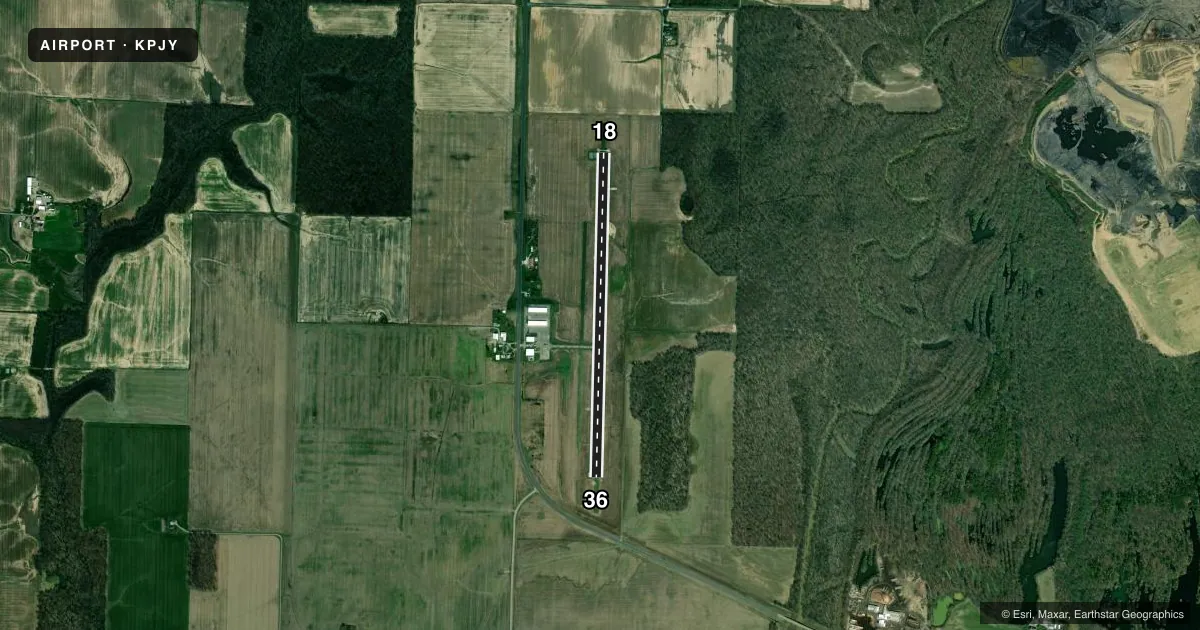
Airport sketch
Runways drawn to scale from FAA survey coordinates, rendered over satellite imagery. Not for navigation.
Approaches & charts
Services on the field
Fuel grades, oxygen, maintenance, ramp storage and lighting — as declared to the FAA by the airport operator.
Fuel & services
- Fuel
- 100LL
- Oxygen (bottled)
- Not available
- Oxygen (bulk)
- Not available
- Other services
- INSTR,RNTL
Ramp & ground
- Transient storage
- Tie-down
- Hangar
- Lighting schedule
- SEE RMK
- Beacon schedule
- SS-SR
- Beacon
- White / Green (civil land)(WG)
- Wind indicator
- Lighted
- Segmented circle
- No
Fuel & FBOs
Cheapest 100LL and Jet A on the field and nearby. Always confirm with the FBO before taxi.
Airport notes
Surface conditions, obstructions, local procedures, lighting outages and other notes published with each FAA cycle.
General notes
- FOR SVC CALL ACFT MAINT, 618-443-2002.
- ULTRALIGHT OPS ON AND INVOF ARPT.
- WILDLIFE ON & INVOF ARPT.
- FUEL IS SELF SVC WITH CREDIT CARD.
- FOR EMERG CALL POLICE DEPT 618-357-8231 OR 911.
- ULTRALIGHT TKOF AND LDG OPS ON GRASS ON WEST SIDE OF RWY.
- FOR CD CTC KANSAS CITY ARTCC AT 913-254-8508.
Lighting notes
- ACTVT REIL RWY 18 & 36. MIRL RWY 18/36 PRESET TO LOW INTST, TO INCR INTST & ACTVT - CTAF.
Approach & departure obstructions
- 18RWY 18 PAPI UNUSBL BYD 8 DEGS RIGHT OF CNTRLN.
Other notes
- TPA: 400 FT AGL ULTRALIGHTS, 800 FT AGL ALL OTR ACFT.
VFR map & nearby airports
VFR sectional. Tap any ICAO chip to open that airport.
Key facts · KPJY
Answer card- ICAO
- KPJY
- Name
- PINCKNEYVILLE/DU QUOIN
- Location
- PINCKNEYVILLE, ILLINOIS
- Elevation
- 400.4 ft MSL
- Traffic pattern altitude
- 800.4 ft MSL (400 AGL)
- Control tower
- Non-towered (use CTAF)
- Total runways
- 1
- Longest runway
- 18/36 · 3,999 ft
- Published ILS approaches
- 0
- Published frequencies
- 2
- Magnetic variation
- 0°
- Current flight rules
- LIFR
- Current wind
- 000° at 0 kt
- Favored runway now
- –
Pinckneyville/Du Quoin Airport (KPJY) sits in Pinckneyville, Illinois. Field elevation is 400.4 ft MSL. The airport has one runway, 18/36, at 3,999 ft. It is a non-towered field. CTAF and UNICOM are both 122.8. No ILS approaches are published here.
Pattern altitude is 400 ft AGL for ultralights. It is 800 feet AGL for all other aircraft. That puts the standard pattern at 800.4 ft MSL for most traffic. Runway 18/36 has runway end identifier lights. The medium intensity lights are preset to low intensity. Use the CTAF to increase intensity and activate them.
Sparta Aero Service is on the field. It carries 100LL. Fuel is self-service with credit card. Ultralight operations occur on and near the airport. Ultralight takeoffs and landings use the grass on the west side of the runway. Wildlife is also reported on and in the vicinity of the airport, so keep a sharp scan on taxi, takeoff and landing. If you need clearance delivery, contact Kansas City ARTCC. Runway 18 also has a published PAPI note. It is unusable beyond 8 degrees right of centerline. For a first-time arrival, plan for a quiet non-towered pattern. Verify lighting before night ops. Expect mixed traffic with ultralights.