METAR & TAF KENL
Current METAR
Observed 08:55Z
KENL 270855Z AUTO 15012G19KT 10SM SCT055 24/21 A2993 RMK AO2 LTG DSNT SE T02400211
- Wind
- 150° @ 12G19 kt
- Visibility
- 10 SM
- Temp / Dew
- 24°C / 21°C
- Altimeter
- 29.93 inHg
- Clouds
- SCT
- Density alt
- 1,730 ft
- Ceiling
- Unlimited
- Rules
- VFR
Airport info & contacts
Manager on record, flight service, ARTCC, attendance schedule and pattern altitude — published by the FAA and refreshed every 28 days.
Location
- From city
- 2 NM SE
- VFR sectional
- ST LOUIS
- ARTCC
- ZKC · KANSAS CITY
- NOTAM facility
- ENL (NOTAM-D)
Airport manager
- Name
- GALEN MAHLE
- Phone
- 618-533-7622
- Address
- 2331 E. CALUMET, CENTRALIA IL 62801
Flight service · Hours
- FSS STL
- SAINT LOUIS1-800-WX-BRIEF
- Attendance
- 0800-DUSK
Frequencies
Tap any row to copy the frequency to your clipboard.
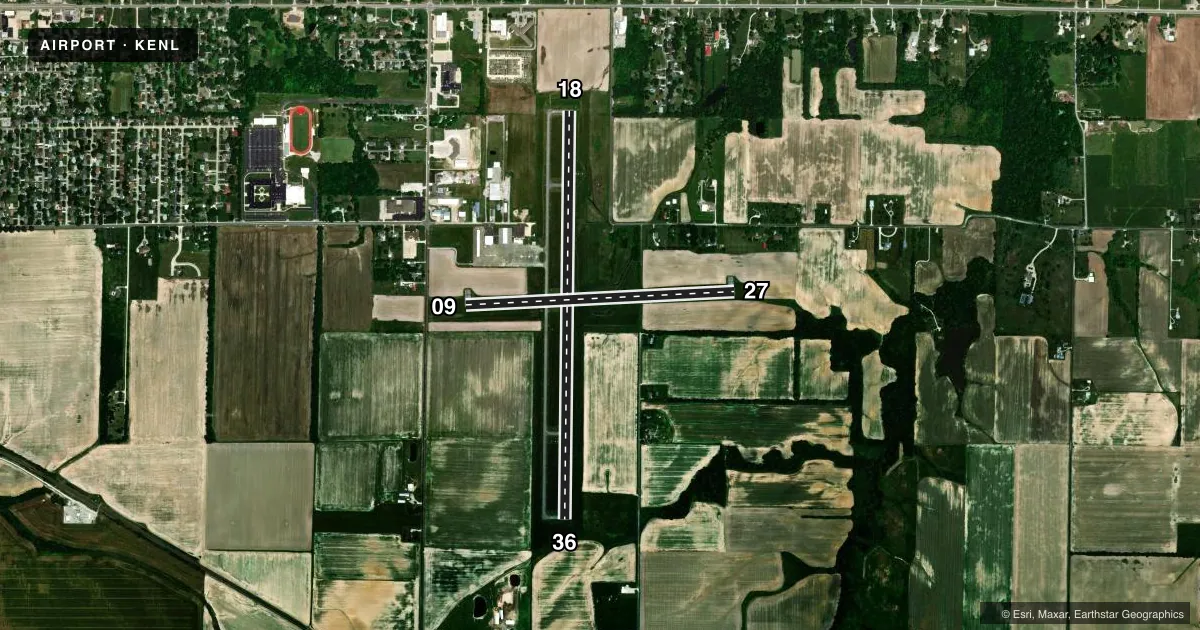
Runways & pattern
Full pagePattern entry · RWY 18
LEFT TRAFFIC| Runway | Heading (°M) | Length | Surface | Traffic |
|---|---|---|---|---|
| 18/36Favored | 179° / 358° | 5,001 ft | ASPH | 36 R |
| 09/27 | 85° / 265° | 3,300 ft | ASPH | 09 R |
Runway end performance
| End | TORA | TODA | ASDA | LDA | VGSI | Approach lights | Obstruction |
|---|---|---|---|---|---|---|---|
| 18 | — | — | — | — | PAPI 2-box left(3°) | — | 49', tree, 1608' from thr, 56' R of cntrln, slope 28 |
| 36 | — | — | — | — | PAPI 2-box left(3°) | — | — |
| 09 | — | — | — | — | — | — | 13', road, 470' from thr, 0' R of cntrln, slope 20 |
Declared distances in feet. TORA = takeoff run available, TODA = takeoff distance, ASDA = accelerate-stop, LDA = landing distance.
Airport sketch
Runways drawn to scale from FAA survey coordinates, rendered over satellite imagery. Not for navigation.
Approaches & charts
Services on the field
Fuel grades, oxygen, maintenance, ramp storage and lighting — as declared to the FAA by the airport operator.
Fuel & services
- Fuel
- 100LLA
- Oxygen (bottled)
- Not available
- Oxygen (bulk)
- Not available
- Other services
- CHTR,INSTR,RNTL,SALES
Ramp & ground
- Transient storage
- Tie-down
- Landing fee
- No fee published
- Customs
- Not available
- Lighting schedule
- SEE RMK
- Beacon schedule
- SS-SR
- Beacon
- White / Green (civil land)(WG)
- Wind indicator
- Lighted
Fuel & FBOs
Cheapest 100LL and Jet A on the field and nearby. Always confirm with the FBO before taxi.
Airport notes
Surface conditions, obstructions, local procedures, lighting outages and other notes published with each FAA cycle.
General notes
- FOR CD IF UNA TO CTC ON FSS FREQ, CTC KANSAS CITY ARTCC AT 913-254-8508.
Lighting notes
- ACTVT MIRL RY 09/27, RY 18/36 & REIL RY 18/36 - CTAF.
Approach & departure obstructions
- 09RWY 9 MARKING POOR.
- 27RWY 27 MARKINGS FADED.
Other notes
- 1FOR SVC AFT HRS CALL (920) 728-4417.
- MANAGEREMAIL ADDRESS: GMAHLE@CITYOFCENTRALIA.ORG (ALL LOWER CASE)
- MANAGERCELL # 618-267-7844
VFR map & nearby airports
VFR sectional. Tap any ICAO chip to open that airport.
Key facts · KENL
Answer card- ICAO
- KENL
- Name
- CENTRALIA MUNI
- Location
- CENTRALIA, ILLINOIS
- Elevation
- 534.1 ft MSL
- Traffic pattern altitude
- 1,534.1 ft MSL (1,000 AGL)
- Control tower
- Non-towered (use CTAF)
- Total runways
- 2
- Longest runway
- 18/36 · 5,001 ft
- Published ILS approaches
- 0
- Published frequencies
- 2
- Magnetic variation
- 2°
- Current flight rules
- VFR
- Current wind
- 150° at 12 kt
- Favored runway now
- RWY 18
Centralia Muni sits in Centralia, Illinois. Field elevation is 534.1 ft MSL. The airport has two asphalt runways. The longest is runway 18/36 at 5,001 ft. Runway 09/27 is 3,300 ft. There is no control tower, so use CTAF 122.8 for traffic calls and UNICOM is also 122.8.
No ILS approaches are published here. Pattern altitude is not published in the facts, so verify the current traffic pattern altitude in the current FAA Chart Supplement before you go. Airgo is on the field. It carries 100LL and Jet A. Call the FBO directly at (618) 533-1643 for current services and availability.
A few published remarks matter for a first-time arrival. Runway 27 markings are faded. Runway 9 markings are poor. Medium intensity runway lights are active on both runways. Runway end identifier lights are on runway 18/36. If you need clearance delivery and cannot reach flight service, Kansas City ARTCC is listed as the backup contact. With no tower and no published ILS, plan your arrival carefully and make your position reports early on CTAF.