METAR & TAF H96
H96 does not publish a METAR.
Showing the nearest reporting station: KMWA (VETERANS AIRPORT OF SOUTHERN ILLINOIS) · 15.6 NM away. Conditions at H96 may differ.
METAR · KMWA
Observed 11:45Z
KMWA 241145Z 02004KT 10SM SCT120 19/17 A3014
- Wind
- 020° @ 4 kt
- Visibility
- 10 SM
- Temp / Dew
- 19°C / 17°C
- Altimeter
- 30.14 inHg
- Clouds
- SCT
- Density alt
- 758 ft
- Ceiling
- Unlimited
- Rules
- VFR
Airport info & contacts
Manager on record, flight service, ARTCC, attendance schedule and pattern altitude — published by the FAA and refreshed every 28 days.
Location
- From city
- 1 NM W
- VFR sectional
- ST LOUIS
- ARTCC
- ZKC · KANSAS CITY
- NOTAM facility
- STL (NOTAM-D)
Airport manager
- Name
- MATTHEW HARRISON
- Phone
- 815-529-1207
- Address
- P.O. BOX 640, BENTON IL 62812
Flight service · Hours
- FSS STL
- SAINT LOUIS1-800-WX-BRIEF
- Attendance
- UNATTND
Frequencies
Tap any row to copy the frequency to your clipboard.
Runways & pattern
Full pagePattern entry · RWY 36
LEFT TRAFFICRunway end performance
| End | TORA | TODA | ASDA | LDA | VGSI | Approach lights | Obstruction |
|---|---|---|---|---|---|---|---|
| 18 | — | — | — | — | PAPI 4-box left(3.33°) | — | — |
Declared distances in feet. TORA = takeoff run available, TODA = takeoff distance, ASDA = accelerate-stop, LDA = landing distance.
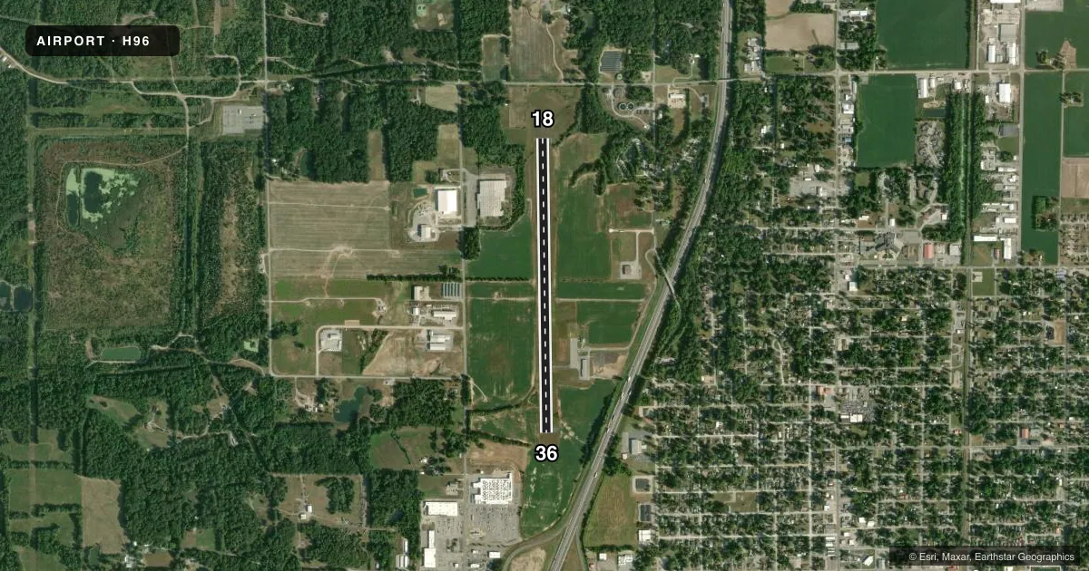
Airport sketch
Runways drawn to scale from FAA survey coordinates, rendered over satellite imagery. Not for navigation.
Approaches & charts
Services on the field
Fuel grades, oxygen, maintenance, ramp storage and lighting — as declared to the FAA by the airport operator.
Fuel & services
- Fuel
- 100LL
- Other services
- INSTR,RNTL,SALES
Ramp & ground
- Transient storage
- Tie-down
- Landing fee
- No fee published
- Customs
- Not available
- Lighting schedule
- SEE RMK
- Beacon schedule
- SS-SR
- Beacon
- White / Green (civil land)(WG)
- Wind indicator
- Lighted
- Segmented circle
- No
Fuel & FBOs
Cheapest 100LL and Jet A on the field and nearby. Always confirm with the FBO before taxi.
Airport notes
Surface conditions, obstructions, local procedures, lighting outages and other notes published with each FAA cycle.
General notes
- FOR CD CTC KANSAS CITY ARTCC AT 913-254-8508.
Lighting notes
- MIRL RY 18/36 PRESET ON LOW INTST; TO INCR INTST ACTVT - CTAF.
Approach & departure obstructions
- 18RWY MARKING FADED.
- 36RWY MARKING FADED.
Other notes
- MANAGEREMAIL AIRPORT@BENTONIL.COM (ALL LWR CASE) MATTHEWHARRISON@HOTMAIL.COM
VFR map & nearby airports
VFR sectional. Tap any ICAO chip to open that airport.
Key facts · H96
Answer card- ICAO
- H96
- Name
- BENTON MUNI
- Location
- BENTON, ILLINOIS
- Elevation
- 444.1 ft MSL
- Traffic pattern altitude
- 1,444.1 ft MSL (1,000 AGL)
- Control tower
- Non-towered (use CTAF)
- Total runways
- 1
- Longest runway
- 18/36 · 4,002 ft
- Published ILS approaches
- 0
- Published frequencies
- 2
- Magnetic variation
- 2°
- Current flight rules
- VFR
- Current wind
- 020° at 4 kt
- Favored runway now
- RWY 36
Benton Muni sits in Benton, Illinois at 444.1 ft MSL. It has one runway, 18/36, which is 4,002 ft long with asphalt pavement. The field is not towered. CTAF and UNICOM are both 122.8. No ILS approaches are published here.
Pattern altitude is not published. Use the standard 1,000 ft AGL pattern for light piston operations unless the current Chart Supplement says otherwise. The runway lights on 18/36 are preset to low intensity. You can increase them by keying the CTAF. Runway 18 markings are faded. Runway 36 markings are faded too, so plan your landing and rollout with that in mind.
There are no on-field FBOs listed in the facts, so verify fuel and services with the airport operator before you go. For clearance delivery, contact Kansas City ARTCC at 913-254-8508. Pilots should also check the current Chart Supplement for any published restrictions before flying in. The airport manager contact is listed in the remarks if you need local coordination.