METAR & TAF KMVN
Current METAR
Observed 16:56Z
KMVN 261656Z AUTO 00000KT 10SM FEW014 32/27 A2996 RMK AO2 SLP146 T03220272 $
- Wind
- 000° @ 0 kt
- Visibility
- 10 SM
- Temp / Dew
- 32°C / 27°C
- Altimeter
- 29.96 inHg
- Clouds
- FEW
- Density alt
- 2,586 ft
- Ceiling
- Unlimited
- Rules
- VFR
Airport info & contacts
Manager on record, flight service, ARTCC, attendance schedule and pattern altitude — published by the FAA and refreshed every 28 days.
Location
- From city
- 3 NM E
- VFR sectional
- ST LOUIS
- ARTCC
- ZKC · KANSAS CITY
- NOTAM facility
- MVN (NOTAM-D)
Airport manager
- Name
- CHRIS COLLINS
- Phone
- 618-242-7016
- Address
- 100 AVIATION DRIVE, MT VERNON IL 62864
Flight service · Hours
- FSS STL
- SAINT LOUIS1-800-WX-BRIEF
- Attendance
- 0630-2000
Frequencies
Tap any row to copy the frequency to your clipboard.
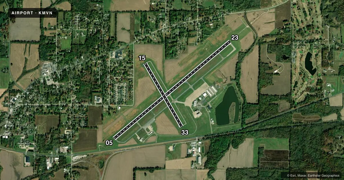
Runways & pattern
Full pagePattern entry · RWY 05
LEFT TRAFFIC| Runway | Heading (°M) | Length | Surface | Traffic |
|---|---|---|---|---|
| 05/23 | 49° / 229° | 6,496 ft | ASPH | Standard L |
| 15/33 | 149° / 329° | 3,146 ft | ASPH | Standard L |
Runway end performance
| End | TORA | TODA | ASDA | LDA | VGSI | Approach lights | Obstruction |
|---|---|---|---|---|---|---|---|
| 05 | 6,496' | 6,496' | 6,496' | 5,722' | VASI 4-box left(3°) | — | 12', road, 200' from thr, 395' R of cntrln, slope 0 |
| 23 | 5,572' | 5,572' | 5,572' | 5,572' | — | MALSR | 97', trees, 2988' from thr, 54' R of cntrln, slope 28 |
| 15 | 3,146' | 3,146' | 3,146' | 3,146' | — | — | 63', tree, 873' from thr, 180' R of cntrln, slope 10 |
| 33 | 3,146' | 3,146' | 3,146' | 3,146' | — | — | 23', rr, 613' from thr, 166' R of cntrln, slope 19 |
Declared distances in feet. TORA = takeoff run available, TODA = takeoff distance, ASDA = accelerate-stop, LDA = landing distance.
Airport sketch
Runways drawn to scale from FAA survey coordinates, rendered over satellite imagery. Not for navigation.
Approaches & charts
ILS · 1
Services on the field
Fuel grades, oxygen, maintenance, ramp storage and lighting — as declared to the FAA by the airport operator.
Fuel & services
- Fuel
- 100LLA
- Oxygen (bulk)
- Low pressure
- Airframe repair
- Major
- Power plant repair
- Major
- Other services
- CARGO,CHTR,INSTR,RNTL,SALES
Ramp & ground
- Transient storage
- Tie-down
- Hangar
- Landing fee
- No fee published
- Customs
- Not available
- Lighting schedule
- SEE RMK
- Beacon schedule
- SS-SR
- Beacon
- White / Green (civil land)(WG)
- Wind indicator
- Lighted
- Segmented circle
- Yes
Fuel & FBOs
Cheapest 100LL and Jet A on the field and nearby. Always confirm with the FBO before taxi.
Airport notes
Surface conditions, obstructions, local procedures, lighting outages and other notes published with each FAA cycle.
General notes
- MIGRATORY WATERFOWL INVOF ARPT.
- FOR CD CTC KANSAS CITY ARTCC AT 913-254-8508.
Lighting notes
- ACTVT MALSR RY 23 - CTAF. ACTVT MIRL RY 15/33 & HIRL RY 05/23 - CTAF NIGHT ONLY.
Runway surface & condition
- 05/23PCR VALUE: 550/F/D/X/T
- 15/33PCR VALUE: 220/F/D/X/T
- 05/23RWY 05/23 NOT AVBL FOR PART 121/PART 380 OPS WITH SKED PAX CARRYING OPS MORE THAN 9 PAX SEATS AND NON-SKED PAX CARRYING OPS MORE THAN 30 PAX SEATS. 90 DAY PPR FOR UNSKED ACR OPS GTR THAN 30 PAX SEATS - CALL AMGR. 618-242-7016
- 15/33RWY 15/33 NOT AVBL FOR PART 121/PART 380 OPS WITH SKED PAX CARRYING OPS MORE THAN 9 PAX SEATS AND NON-SKED PAX CARRYING OPS MORE THAN 30 PAX SEATS. 90 DAY PPR FOR UNSKED ACR OPS GTR THAN 30 PAX SEATS - CALL AMGR. 618-242-7016
- H1FOR PVT USE BY AIR-EVAC LIFETEAM ONLY.
Approach & departure obstructions
- 23RY 23 MALSR AVBL DALGT HRS.
- 0512 FT ROAD 0-200 FT FM THLD 395 FT R TO 495 FT R OF CNTRLN.
- 05APCH RATIO TO DSPLCD THLD 34:1 OVR TREES 2583 FT FM DSPLCD THLD 158 FT R OF CNTRLN.
- 05ALSO 18 FT RR 238 FT FM RY END 498 FT R OF CNTRLN 2:1 SLOPE.
Other notes
- 1FOR SVCS AFT HRS CALL 618-315-5462.
VFR map & nearby airports
VFR sectional. Tap any ICAO chip to open that airport.
Key facts · KMVN
Answer card- ICAO
- KMVN
- Name
- MOUNT VERNON
- Location
- MOUNT VERNON, ILLINOIS
- Elevation
- 480.4 ft MSL
- Traffic pattern altitude
- 1,480.4 ft MSL (1,000 AGL)
- Control tower
- Non-towered (use CTAF)
- Total runways
- 2
- Longest runway
- 05/23 · 6,496 ft
- Published ILS approaches
- 1
- Published frequencies
- 2
- Magnetic variation
- 1°
- Current flight rules
- VFR
- Current wind
- 000° at 0 kt
- Favored runway now
- –
Mount Vernon Airport sits in Mount Vernon, Illinois. Field elevation is 480.4 ft MSL. It has two asphalt runways. The longest is 05/23 at 6,496 ft. The airport is non-towered. CTAF and UNICOM are both 123.0. Runway 23 has an ILS approach. The published pattern altitude is not listed, so use the standard 1,000 ft AGL for light piston traffic unless the current Chart Supplement says otherwise.
SRT Flightline is on the field. It carries 100LL and Jet A Prist. For after-hours service, the published remarks give a phone number to call. The remarks also note migratory waterfowl in the area, so expect bird activity on arrival and departure. Runway 23 has MALSR lighting available during daylight hours. Clearance delivery is handled through Kansas City ARTCC by phone, which is useful to know if you need IFR services before departure.
There are a few runway-specific items to brief before you go. Runway 05 has published obstacle notes near the approach end. Runway 15/33 and 05/23 both have restrictions for certain large passenger operations. If you are planning anything outside normal GA use, call the airport manager first. The field is in a part of Illinois where weather and bird activity can change the picture quickly. A current check of runway condition, winds and the latest Chart Supplement is smart before launch.