METAR & TAF KHSB
Current METAR
Observed 12:35Z
KHSB 271235Z AUTO 01006KT 10SM CLR 22/20 A2996 RMK AO2 T02220204
- Wind
- 010° @ 6 kt
- Visibility
- 10 SM
- Temp / Dew
- 22°C / 20°C
- Altimeter
- 29.96 inHg
- Clouds
- CLR
- Density alt
- 1,284 ft
- Ceiling
- Unlimited
- Rules
- VFR
Airport info & contacts
Manager on record, flight service, ARTCC, attendance schedule and pattern altitude — published by the FAA and refreshed every 28 days.
Location
- From city
- 4 NM N
- VFR sectional
- ST LOUIS
- ARTCC
- ZKC · KANSAS CITY
- NOTAM facility
- HSB (NOTAM-D)
Airport manager
- Name
- DALE SHELTON
- Phone
- 618-253-7806
- Address
- P.O. BOX 33, HARRISBURG IL 62946
Flight service · Hours
- FSS STL
- SAINT LOUIS1-800-WX-BRIEF
- Attendance
- 0800-1700
Frequencies
Tap any row to copy the frequency to your clipboard.
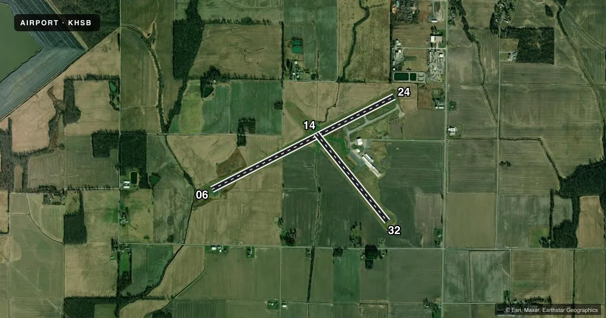
Runways & pattern
Full pagePattern entry · RWY 32
LEFT TRAFFIC| Runway | Heading (°M) | Length | Surface | Traffic |
|---|---|---|---|---|
| 06/24 | 63° / 243° | 5,013 ft | ASPH | Standard L |
| 14/32Favored | 141° / 321° | 2,764 ft | ASPH | Standard L |
Runway end performance
| End | TORA | TODA | ASDA | LDA | VGSI | Approach lights | Obstruction |
|---|---|---|---|---|---|---|---|
| 06 | — | — | — | — | PAPI 4-box left(3°) | — | — |
| 24 | — | — | — | — | PAPI 4-box left(3°) | — | 31', tree, 721' from thr, 179' R of cntrln, slope 16 |
Declared distances in feet. TORA = takeoff run available, TODA = takeoff distance, ASDA = accelerate-stop, LDA = landing distance.
Airport sketch
Runways drawn to scale from FAA survey coordinates, rendered over satellite imagery. Not for navigation.
Approaches & charts
Services on the field
Fuel grades, oxygen, maintenance, ramp storage and lighting — as declared to the FAA by the airport operator.
Fuel & services
- Fuel
- 100LLA
- Airframe repair
- Minor
- Power plant repair
- Minor
Ramp & ground
- Transient storage
- Tie-down
- Hangar
- Landing fee
- No fee published
- Customs
- Not available
- Lighting schedule
- SEE RMK
- Beacon schedule
- SS-SR
- Beacon
- White / Green (civil land)(WG)
- Wind indicator
- Lighted
- Segmented circle
- Yes
Fuel & FBOs
Cheapest 100LL and Jet A on the field and nearby. Always confirm with the FBO before taxi.
Airport notes
Surface conditions, obstructions, local procedures, lighting outages and other notes published with each FAA cycle.
General notes
- ULTRALIGHT ACTIVITY ON & INVOF ARPT.
- FOR SVCS OR JET A FUEL AFT HRS CALL AMGR AT 618-499-5058 (CELL).
- 24 HR SELF SERVE 100LL FUEL AVBL WITH CREDIT CARD.
- FOR CD CTC KANSAS CITY ARTCC AT 913-254-8508.
Lighting notes
- REIL RWY 06 & 24; MIRL RWY 06/24 PRESET ON LOW INTST; TO INCR INTST & ACTVT MIRL RWY 14/32 - CTAF.
Runway surface & condition
- 14/32HAS A 900 FT STWY NW END.
Other notes
- MANAGEREMAIL ADDRESS: DSHELTON1018@GMAIL.COM (ALL LOWER CASE)
VFR map & nearby airports
VFR sectional. Tap any ICAO chip to open that airport.
Key facts · KHSB
Answer card- ICAO
- KHSB
- Name
- HARRISBURG-RALEIGH
- Location
- HARRISBURG, ILLINOIS
- Elevation
- 398 ft MSL
- Traffic pattern altitude
- 1,398 ft MSL (1,000 AGL)
- Control tower
- Non-towered (use CTAF)
- Total runways
- 2
- Longest runway
- 06/24 · 5,013 ft
- Published ILS approaches
- 0
- Published frequencies
- 2
- Magnetic variation
- 0°
- Current flight rules
- VFR
- Current wind
- 010° at 6 kt
- Favored runway now
- RWY 32
Harrisburg-Raleigh Airport sits in Harrisburg, Illinois. Field elevation is 398 ft MSL. It has two asphalt runways. The longest is 5,013 ft on runway 06/24. There is no control tower. CTAF and UNICOM are both 122.8. No ILS approaches are published here.
Pattern altitude is not published, so plan on the standard 1,000 ft AGL for light piston traffic unless the current Chart Supplement says otherwise. The on-field FBO is Harrisburg-Raleigh Airport. It carries AVGAS 100LL and Jet A Prist. Twenty-four hour self-serve 100LL is available with credit card. If you need Jet A after hours, call the airport manager first.
Runway lighting is a little specific here. Runway end identifier lights are installed on 06 and 24. The medium intensity lights on 06 and 24 come up at low intensity by default. To raise intensity and turn on the medium intensity lights for 14 and 32, use the CTAF. Runway 14/32 also has a 900 ft stopway at the northwest end. Ultralight activity occurs on and near the airport, so keep your scan active in the pattern. For clearance delivery, contact Kansas City ARTCC. Check the current Chart Supplement for any published noise or curfew restrictions before flying in.