METAR & TAF KGDA
Current METAR
Observed 09:35Z
KGDA 270935Z AUTO 32011KT 10SM -RA SCT003 SCT055 BKN120 20/19 A3000 RMK AO2 P0001 T02000191
- Wind
- 320° @ 11 kt
- Visibility
- 10 SM
- Temp / Dew
- 20°C / 19°C
- Altimeter
- 30.00 inHg
- Clouds
- BKN
- Density alt
- 1,310 ft
- Ceiling
- 12,000 ft AGL
- Rules
- VFR
Airport info & contacts
Manager on record, flight service, ARTCC, attendance schedule and pattern altitude — published by the FAA and refreshed every 28 days.
Location
- From city
- 1 NM SW
- VFR sectional
- ST LOUIS
- ARTCC
- ZME · MEMPHIS
- NOTAM facility
- LOU (NOTAM-D)
Airport manager
- Name
- JIM JOHNSON
- Phone
- 270-965-4242
- Address
- 500 AIRPORT ROAD, MARION KY 42064
Flight service · Hours
- FSS LOU
- LOUISVILLE1-800-WX-BRIEF
- Attendance
- Unattended
Frequencies
Tap any row to copy the frequency to your clipboard.
Runways & pattern
Full pagePattern entry · RWY 25
LEFT TRAFFICRunway end performance
| End | TORA | TODA | ASDA | LDA | VGSI | Approach lights | Obstruction |
|---|---|---|---|---|---|---|---|
| 07 | — | — | — | — | PAPI 4-box left(3°) | — | 42', trees, 703' from thr, 288' R of cntrln, slope 11 |
| 25 | — | — | — | — | PAPI 4-box left(3°) | — | — |
Declared distances in feet. TORA = takeoff run available, TODA = takeoff distance, ASDA = accelerate-stop, LDA = landing distance.
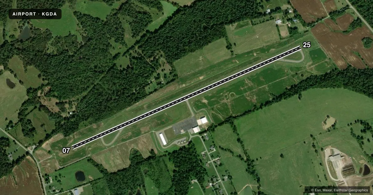
Airport sketch
Runways drawn to scale from FAA survey coordinates, rendered over satellite imagery. Not for navigation.
Approaches & charts
Services on the field
Fuel grades, oxygen, maintenance, ramp storage and lighting — as declared to the FAA by the airport operator.
Fuel & services
- Fuel
- 100LLA+
- Oxygen (bottled)
- Not available
- Oxygen (bulk)
- Not available
- Airframe repair
- Not available
- Power plant repair
- Not available
- Other services
- INSTR
Ramp & ground
- Transient storage
- Tie-down
- Hangar
- Landing fee
- No fee published
- Lighting schedule
- SEE RMK
- Beacon schedule
- SS-SR
- Beacon
- White / Green (civil land)(WG)
- Wind indicator
- Yes
- Segmented circle
- Yes
Fuel & FBOs
Cheapest 100LL and Jet A on the field and nearby. Always confirm with the FBO before taxi.
Airport notes
Surface conditions, obstructions, local procedures, lighting outages and other notes published with each FAA cycle.
General notes
- RWY COND - AMGR.
- CRITTENDEN CO HOSP HELI 1 NM SE.
- FOR CD CTC MEMPHIS ARTCC AT 901-368-8453/8449.
Lighting notes
- ACTVT REIL RWY 7 & 25; PAPI RWY 7 & 25; MIRL RWY 07/25 - CTAF.
Other notes
- VFR USE ONLY.
VFR map & nearby airports
VFR sectional. Tap any ICAO chip to open that airport.
Key facts · KGDA
Answer card- ICAO
- KGDA
- Name
- MARION-CRITTENDEN COUNTY JAMES C JOHNSON RGNL
- Location
- MARION, KENTUCKY
- Elevation
- 652.7 ft MSL
- Traffic pattern altitude
- 1,652.7 ft MSL (1,000 AGL)
- Control tower
- Non-towered (use CTAF)
- Total runways
- 1
- Longest runway
- 07/25 · 5,001 ft
- Published ILS approaches
- 0
- Published frequencies
- 1
- Magnetic variation
- 2°
- Current flight rules
- VFR
- Current wind
- 320° at 11 kt
- Favored runway now
- RWY 25
KGDA sits in Marion, Kentucky. The field elevation is 652.7 ft MSL. It has one runway. Runway 07/25 is 5,001 ft long with an asphalt surface. The airport is not towered. CTAF is 122.9. No ILS approaches are published, so plan on VFR work or verify current approach options before you go.
Pattern altitude is not published. Use 1,000 ft AGL for light piston traffic unless the current Chart Supplement says otherwise. The airport is marked for VFR use only. That matters here. Clearance delivery for IFR coordination goes through Memphis ARTCC by phone. There is no local tower.
Marion-Crittenden County Airport is the on-field FBO. It carries 100LL and Jet A. Call the field at (270) 965-4242 for current service details before arrival. The runway lighting is pilot-controlled on CTAF. REILs are installed on both runway ends. PAPI is also installed on 07 and 25.
For a first-time arrival, the main things to verify are the VFR-only status, the lack of published ILS and runway condition information with the airport manager. A hospital helicopter landing area sits 1 NM southeast of the airport. Keep that in mind when scanning the area.