METAR & TAF 1M9
1M9 does not publish a METAR.
Showing the nearest reporting station: KHVC (HOPKINSVILLE-CHRISTIAN COUNTY) · 21.9 NM away. Conditions at 1M9 may differ.
METAR · KHVC
Observed 11:35Z
KHVC 271135Z AUTO 00000KT 10SM CLR 21/21 A2992 RMK A01
- Wind
- 000° @ 0 kt
- Visibility
- 10 SM
- Temp / Dew
- 21°C / 21°C
- Altimeter
- 29.92 inHg
- Clouds
- CLR
- Density alt
- 1,428 ft
- Ceiling
- Unlimited
- Rules
- VFR
Airport info & contacts
Manager on record, flight service, ARTCC, attendance schedule and pattern altitude — published by the FAA and refreshed every 28 days.
Location
- From city
- 4 NM SW
- VFR sectional
- ST LOUIS
- ARTCC
- ZME · MEMPHIS
- NOTAM facility
- LOU (NOTAM-D)
Airport manager
- Name
- ASHLEY JOINER
- Phone
- 270-924-1131
- Address
- 3500 STATE PARK ROAD, CADIZ KY 42211
Flight service · Hours
- FSS LOU
- LOUISVILLE1-800-WX-BRIEF
- Attendance
- Unattended
Frequencies
Tap any row to copy the frequency to your clipboard.
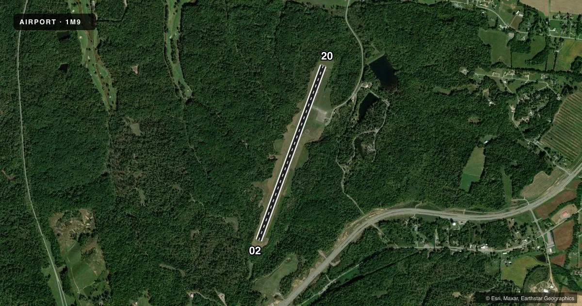
Runways & pattern
Full pagePattern entry · RWY 02
LEFT TRAFFICRunway end performance
| End | TORA | TODA | ASDA | LDA | VGSI | Approach lights | Obstruction |
|---|---|---|---|---|---|---|---|
| 02 | 4,800' | 4,800' | 4,800' | 4,600' | — | — | 23', trees, 215' from thr, 150' R of cntrln, slope 0 |
| 20 | 4,800' | 4,800' | 4,800' | 4,600' | PAPI 2-box left(4°) | — | 27', trees, 201' from thr, 86' R of cntrln, slope 0 |
Declared distances in feet. TORA = takeoff run available, TODA = takeoff distance, ASDA = accelerate-stop, LDA = landing distance.
Airport sketch
Runways drawn to scale from FAA survey coordinates, rendered over satellite imagery. Not for navigation.
Approaches & charts
Services on the field
Fuel grades, oxygen, maintenance, ramp storage and lighting — as declared to the FAA by the airport operator.
Fuel & services
- Fuel
- Not available
Ramp & ground
- Transient storage
- Tie-down
- Landing fee
- No fee published
- Lighting schedule
- SEE RMK
- Beacon schedule
- SS-SR
- Beacon
- White / Green (civil land)(WG)
- Wind indicator
- Lighted
- Segmented circle
- Yes
Fuel & FBOs
Cheapest 100LL and Jet A on the field and nearby. Always confirm with the FBO before taxi.
Airport notes
Surface conditions, obstructions, local procedures, lighting outages and other notes published with each FAA cycle.
General notes
- PARK LODGE T/R - 270-924-1131
- DEER & BIRDS ON & INVOF ARPT.
- FOR CD CTC CAMPBELL APCH AT 270-798-6441.
Lighting notes
- ACTVT REIL RWY 02 & 20; PAPI RWY 20; MIRL RWY 02/20 - CTAF.
Approach & departure obstructions
- 02TREE 198 FT FM END OF RWY, 128 FT L OF RWY END. TREES 82 FT - 191 FT FM RWY END, 165 FT-237 FT R OF RWY END.
- 20TREE 198 FT FM END OF RWY, 237 FT L OF RWY END. TREES 33 FT - 178 FT FM RWY END, 143 FT- 171 FT R OF RWY END.
- 02TREES 0:1 TO RWY END
Other notes
- VFR USE ONLY.
VFR map & nearby airports
VFR sectional. Tap any ICAO chip to open that airport.
Key facts · 1M9
Answer card- ICAO
- 1M9
- Name
- LAKE BARKLEY STATE PARK
- Location
- CADIZ, KENTUCKY
- Elevation
- 570.9 ft MSL
- Traffic pattern altitude
- 1,570.9 ft MSL (1,000 AGL)
- Control tower
- Non-towered (use CTAF)
- Total runways
- 1
- Longest runway
- 02/20 · 4,800 ft
- Published ILS approaches
- 0
- Published frequencies
- 2
- Magnetic variation
- 0°
- Current flight rules
- VFR
- Current wind
- 000° at 0 kt
- Favored runway now
- –
Lake Barkley State Park Airport (1M9) sits in Cadiz, Kentucky. Field elevation is 570.9 ft MSL. The airport has one runway. Runway 02/20 is 4,800 ft of asphalt, which is the longest runway on the field. There is no control tower. CTAF and UNICOM are both 123.0.
No ILS approaches are published here. This is VFR use only. Pattern altitude is not published, so use the standard 1,000 ft AGL for light piston traffic unless the current FAA Chart Supplement says otherwise. The runway has medium intensity lights. Runway end identifier lights are installed on both ends. PAPI is available on runway 20.
There are no on-field FBOs listed, so verify fuel and services with the airport operator or call the field directly before arrival. Published remarks also call out deer and birds in the area. Trees are close off both runway ends, with specific obstructions noted near 02 and 20. That makes a stabilized approach important here, especially if you are arriving at night or in marginal conditions. For clearance delivery, contact Campbell Approach at 270-798-6441. The Park Lodge number is 270-924-1131.