METAR & TAF KCKV
Current METAR
Observed 03:52Z
KCKV 270352Z AUTO 20006KT 10SM CLR 23/22 A2993 RMK AO2 LTG DSNT S-W RAE0259 SLP127 P0000 T02330217
- Wind
- 200° @ 6 kt
- Visibility
- 10 SM
- Temp / Dew
- 23°C / 22°C
- Altimeter
- 29.93 inHg
- Clouds
- CLR
- Density alt
- 1,629 ft
- Ceiling
- Unlimited
- Rules
- VFR
Airport info & contacts
Manager on record, flight service, ARTCC, attendance schedule and pattern altitude — published by the FAA and refreshed every 28 days.
Location
- From city
- 6 NM NW
- VFR sectional
- ST LOUIS
- Pattern altitude
- 1,050 ft AGL · 1,600 ft MSL
- ARTCC
- ZME · MEMPHIS
- NOTAM facility
- CKV (NOTAM-D)
Airport manager
- Name
- JOHN PATTERSON
- Phone
- 931-431-2080
- Address
- 200 AIRPORT ROAD - BLDG 1, CLARKSVILLE TN 37042
Flight service · Hours
- FSS MKL
- JACKSON1-800-WX-BRIEF
- Attendance
- MON-FRI · 0700-1800
- SAT-SUN · 0800-1600
Frequencies
Tap any row to copy the frequency to your clipboard.
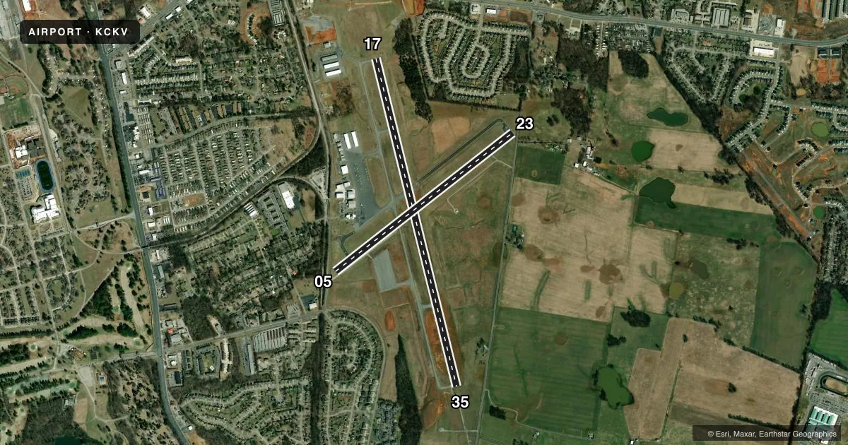
Runways & pattern
Full pagePattern entry · RWY 23
LEFT TRAFFIC| Runway | Heading (°M) | Length | Surface | Traffic |
|---|---|---|---|---|
| 17/35 | 165° / 345° | 5,999 ft | ASPH | 35 R |
| 05/23Favored | 51° / 231° | 4,004 ft | ASPH | 05 R |
Runway end performance
| End | TORA | TODA | ASDA | LDA | VGSI | Approach lights | Obstruction |
|---|---|---|---|---|---|---|---|
| 17 | — | — | — | — | PAPI 2-box left(3°) | — | 101', tree, 2357' from thr, 484' R of cntrln, slope 21 |
| 35 | — | — | — | — | PAPI 2-box left(3°) | MALS | 75', tree, 2156' from thr, 377' R of cntrln, slope 26 |
| 05 | 4,004' | 4,004' | 3,501' | 3,099' | — | — | 44', tree, 365' from thr, 63' R of cntrln, slope 3 |
| 23 | 4,004' | 4,004' | 3,602' | 3,099' | — | — | 86', tree, 1057' from thr, 28' R of cntrln, slope 9 |
Declared distances in feet. TORA = takeoff run available, TODA = takeoff distance, ASDA = accelerate-stop, LDA = landing distance.
Airport sketch
Runways drawn to scale from FAA survey coordinates, rendered over satellite imagery. Not for navigation.
Approaches & charts
ILS · 1
Services on the field
Fuel grades, oxygen, maintenance, ramp storage and lighting — as declared to the FAA by the airport operator.
Fuel & services
- Fuel
- 100LLA+
- Airframe repair
- Major
- Power plant repair
- Major
- Other services
- AMB,INSTR,RNTL
Ramp & ground
- Transient storage
- Tie-down
- Hangar
- Landing fee
- No fee published
- Customs
- Not available
- Lighting schedule
- SEE RMK
- Beacon schedule
- SS-SR
- Beacon
- White / Green (civil land)(WG)
- Wind indicator
- Lighted
- Segmented circle
- Yes
Fuel & FBOs
Cheapest 100LL and Jet A on the field and nearby. Always confirm with the FBO before taxi.
Airport notes
Surface conditions, obstructions, local procedures, lighting outages and other notes published with each FAA cycle.
General notes
- EXTSV MIL & CIVIL FLIGHT TRNG WITHIN ARPT AREA.
- DEER ON & INVOF ARPT.
- FOR CD WHEN UNA VIA FREQ CTC CAMPBELL APCH AT 270-798-6441.
Lighting notes
- ACTVT MALS RWY 35; REIL RWY 17 - CTAF.
Fuel notes
- 100LLAFT HR SVC - 931-217-8765.
Runway surface & condition
- 05/23CLSD INDEFLY.
Approach & departure obstructions
- 05FENCE 100 FT FM RWY END.
- 23FENCE 100 FT FM RWY END.
- 05PEELING & FADED.
- 23PEELING & FADED.
- 17PAPI RWY 17 UNUSBL BYD 9 DEGS RIGHT OF CNTLN.
- 05APCH RATIO 12:1 TO DSPLCD THR.
- 23APCH RATIO 19:1 TO DSPLCD THR.
Other notes
- 1ARPT UNATNDD CHRISTMAS, THANKSGIVING & NEW YEAR.
VFR map & nearby airports
VFR sectional. Tap any ICAO chip to open that airport.
Key facts · KCKV
Answer card- ICAO
- KCKV
- Name
- OUTLAW FLD
- Location
- CLARKSVILLE, TENNESSEE
- Elevation
- 549.9 ft MSL
- Traffic pattern altitude
- 1,599.9 ft MSL (1,050 AGL)
- Control tower
- Non-towered (use CTAF)
- Total runways
- 2
- Longest runway
- 17/35 · 5,999 ft
- Published ILS approaches
- 1
- Published frequencies
- 5
- Magnetic variation
- 1°
- Current flight rules
- VFR
- Current wind
- 200° at 6 kt
- Favored runway now
- RWY 23
Outlaw Fld sits in Clarksville, Tennessee. Field elevation is 549.9 ft MSL. The airport has two asphalt runways. The longest is runway 17/35 at 5,999 ft. Runway 05/23 is 4,004 ft. It is closed indefinitely, so plan around 17/35 for current operations. There is no control tower. CTAF and UNICOM are both 122.8. Campbell Approach handles the approach and departure frequencies listed in the Chart Supplement.
Pattern altitude is 1,050 ft AGL, which is 1,599.9 ft MSL. The field has 1 ILS approach. It is for runway 35. That makes runway 35 the key instrument runway to brief before arrival. Published remarks also note heavy military and civil flight training in the area. Expect busy traffic and stay sharp on the radio.
Clarksville Regional Airport is the on-field FBO. It carries AVGAS 100LL and JET A. The published remarks also note after-hours 100LL service by phone. Runway 17 has a PAPI. It is unusable beyond 9 degrees right of centerline. Runway 35 has MALSR lighting that is activated by CTAF. Runway 05 and 23 markings are faded. There are fences 100 ft from each end of runway 05/23. Check the current FAA Chart Supplement for any current operational notes before you go.