METAR & TAF M02
Current METAR
Observed 10:55Z
KM02 271055Z AUTO 29005KT 9SM 22/22 A3000 RMK A01 P0002
- Wind
- 290° @ 5 kt
- Visibility
- 9 SM
- Temp / Dew
- 22°C / 22°C
- Altimeter
- 30.00 inHg
- Clouds
- Clear
- Density alt
- 1,847 ft
- Ceiling
- Unlimited
- Rules
- VFR
Airport info & contacts
Manager on record, flight service, ARTCC, attendance schedule and pattern altitude — published by the FAA and refreshed every 28 days.
Location
- From city
- 3 NM N
- VFR sectional
- ST LOUIS
- ARTCC
- ZME · MEMPHIS
- NOTAM facility
- MKL (NOTAM-D)
Airport manager
- Name
- MIKE GALLAGHER
- Phone
- (615) 812-1981
- Address
- 2372 SYLVIA RD, DICKSON TN 37056
Flight service · Hours
- FSS MKL
- JACKSON1-800-WX-BRIEF
- Attendance
- 0800-1800
Frequencies
Tap any row to copy the frequency to your clipboard.
Runways & pattern
Full pagePattern entry · RWY 35
LEFT TRAFFICRunway end performance
| End | TORA | TODA | ASDA | LDA | VGSI | Approach lights | Obstruction |
|---|---|---|---|---|---|---|---|
| 17 | — | — | — | — | — | — | 13', tree, 335' from thr, 51' R of cntrln, slope 10 |
| 35 | — | — | — | — | — | — | 52', tree, 836' from thr, 128' R of cntrln, slope 12 |
Declared distances in feet. TORA = takeoff run available, TODA = takeoff distance, ASDA = accelerate-stop, LDA = landing distance.
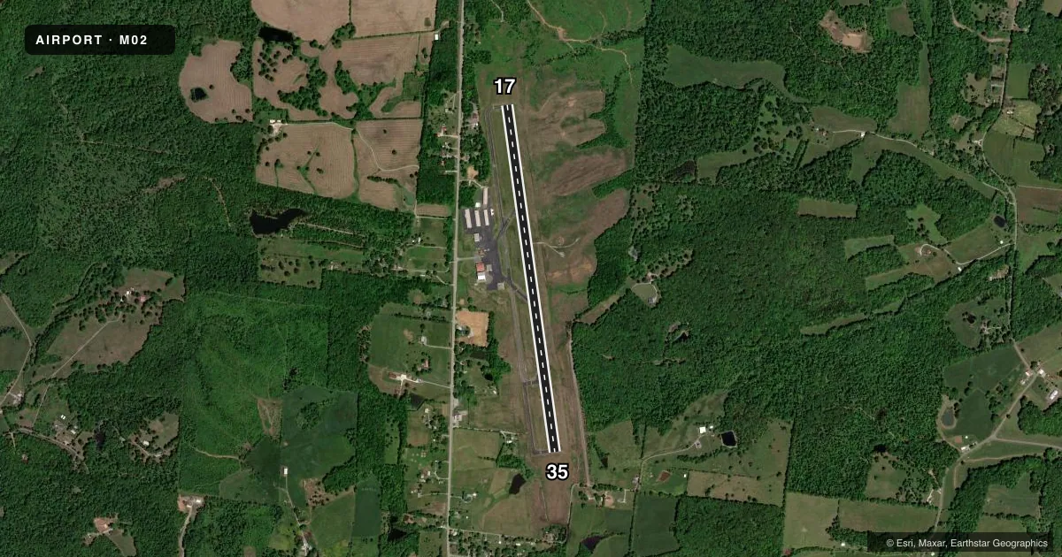
Airport sketch
Runways drawn to scale from FAA survey coordinates, rendered over satellite imagery. Not for navigation.
Approaches & charts
Services on the field
Fuel grades, oxygen, maintenance, ramp storage and lighting — as declared to the FAA by the airport operator.
Fuel & services
- Fuel
- 100LLA+
- Oxygen (bottled)
- Not available
- Oxygen (bulk)
- Not available
- Airframe repair
- Minor
- Power plant repair
- Major
- Other services
- INSTR,RNTL
Ramp & ground
- Transient storage
- Tie-down
- Landing fee
- No fee published
- Customs
- Not available
- Lighting schedule
- SS-SR
- Beacon schedule
- SS-SR
- Beacon
- White / Green (civil land)(WG)
- Wind indicator
- Lighted
- Segmented circle
- Yes
Fuel & FBOs
Cheapest 100LL and Jet A on the field and nearby. Always confirm with the FBO before taxi.
Airport notes
Surface conditions, obstructions, local procedures, lighting outages and other notes published with each FAA cycle.
General notes
- FOR CD CTC NASHVILLE APCH AT 615-695-4524.
Other notes
- 1AFT HR - AMGR.
VFR map & nearby airports
VFR sectional. Tap any ICAO chip to open that airport.
Key facts · M02
Answer card- ICAO
- M02
- Name
- DICKSON MUNI
- Location
- DICKSON, TENNESSEE
- Elevation
- 892.1 ft MSL
- Traffic pattern altitude
- 1,892.1 ft MSL (1,000 AGL)
- Control tower
- Non-towered (use CTAF)
- Total runways
- 1
- Longest runway
- 17/35 · 5,001 ft
- Published ILS approaches
- 0
- Published frequencies
- 4
- Magnetic variation
- 1°
- Current flight rules
- VFR
- Current wind
- 290° at 5 kt
- Favored runway now
- RWY 35
Dickson Muni sits in Dickson, Tennessee. The field elevation is 892.1 ft MSL. It has one runway, 17/35, which is 5,001 ft long on asphalt. The airport is not towered. CTAF and UNICOM are both 122.8. Nashville Approach handles clearance delivery. The published remarks say to contact the airport manager after hours.
No ILS approaches are published here. That makes current weather and a solid arrival plan more important, especially if you are coming in at night or in marginal VFR. The pattern altitude is not published, so use the standard 1,000 ft AGL for light piston traffic unless the current Chart Supplement says otherwise. That puts the pattern at about 1,892 ft MSL based on the field elevation.
The on-field FBO is Dickson County Municipal Airport Authority. It carries 100LL and Jet A with Prist available. If you need current ramp details, fuel service, or after-hours help, call them at (615) 446-6611. For a first visit, expect a simple non-towered airport setup with Nashville area radio coordination. Check the current Chart Supplement for any noise or local operating notes before you go.