METAR & TAF M91
Current METAR
Observed 05:55Z
KM91 270555Z AUTO 36008KT 10SM SCT040 BKN070 OVC110 22/22 A2995 RMK A01
- Wind
- 360° @ 8 kt
- Visibility
- 10 SM
- Temp / Dew
- 22°C / 22°C
- Altimeter
- 29.95 inHg
- Clouds
- OVC
- Density alt
- 1,679 ft
- Ceiling
- 7,000 ft AGL
- Rules
- VFR
Airport info & contacts
Manager on record, flight service, ARTCC, attendance schedule and pattern altitude — published by the FAA and refreshed every 28 days.
Location
- From city
- 3 NM NW
- VFR sectional
- ST LOUIS
- ARTCC
- ZME · MEMPHIS
- NOTAM facility
- BNA (NOTAM-D)
Airport manager
- Name
- BRIAN URBACH
- Phone
- 615-985-4432
- Address
- 4432 AIRPORT RD, SPRINGFIELD TN 37172
Flight service · Hours
- FSS BNA
- NASHVILLE1-800-WX-BRIEF
- Attendance
- APR-OCT · MON-SAT · 0800-1700
- NOV-MAR · MON-SAT · 0800-1600
Frequencies
Tap any row to copy the frequency to your clipboard.
Runways & pattern
Full pagePattern entry · RWY 04
LEFT TRAFFICRunway end performance
| End | TORA | TODA | ASDA | LDA | VGSI | Approach lights | Obstruction |
|---|---|---|---|---|---|---|---|
| 04 | — | — | — | — | PAPI 2-box left(3°) | — | 70', tree, 2196' from thr, 429' R of cntrln, slope 28 |
| 22 | — | — | — | — | PAPI 2-box left(3°) | — | 62', tree, 1147' from thr, 234' R of cntrln, slope 15 |
Declared distances in feet. TORA = takeoff run available, TODA = takeoff distance, ASDA = accelerate-stop, LDA = landing distance.
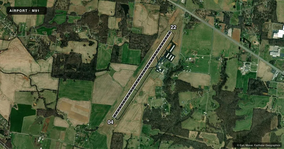
Airport sketch
Runways drawn to scale from FAA survey coordinates, rendered over satellite imagery. Not for navigation.
Approaches & charts
ILS · 1
Services on the field
Fuel grades, oxygen, maintenance, ramp storage and lighting — as declared to the FAA by the airport operator.
Fuel & services
- Fuel
- 100LLA+
- Airframe repair
- Major
- Power plant repair
- Major
- Other services
- INSTR,RNTL
Ramp & ground
- Transient storage
- Tie-down
- Hangar
- Landing fee
- No fee published
- Customs
- Not available
- Lighting schedule
- SEE RMK
- Beacon schedule
- SS-SR
- Beacon
- White / Green (civil land)(WG)
- Wind indicator
- Lighted
- Segmented circle
- Yes
Fuel & FBOs
Cheapest 100LL and Jet A on the field and nearby. Always confirm with the FBO before taxi.
Airport notes
Surface conditions, obstructions, local procedures, lighting outages and other notes published with each FAA cycle.
General notes
- FOR CD CTC NASHVILLE APCH AT 615-695-4524.
- DEP CLIMB TO 500 FT BFR TURN.
- FLT TRNG INVOF ARPT.
- AFT HR ACES - UNICOM.
- CREDIT CARD FUEL AVBL H24.
Lighting notes
- ACTVT REIL RWY 04 & 22; MIRL RWY 04/22 - CTAF. MIRL RWY 04/22 PRESET TO LOW INTST; INCR INTST - CTAF.
Approach & departure obstructions
- 22CALM WIND RWY.
Other notes
- VFR ONLY.
- 2CLSD SUN & FED HOL.
VFR map & nearby airports
VFR sectional. Tap any ICAO chip to open that airport.
Key facts · M91
Answer card- ICAO
- M91
- Name
- SPRINGFIELD ROBERTSON COUNTY
- Location
- SPRINGFIELD, TENNESSEE
- Elevation
- 706.3 ft MSL
- Traffic pattern altitude
- 1,706.3 ft MSL (1,000 AGL)
- Control tower
- Non-towered (use CTAF)
- Total runways
- 1
- Longest runway
- 04/22 · 5,505 ft
- Published ILS approaches
- 1
- Published frequencies
- 4
- Magnetic variation
- 3°
- Current flight rules
- VFR
- Current wind
- 360° at 8 kt
- Favored runway now
- RWY 04
Springfield Robertson County Airport sits in Springfield, Tennessee. Field elevation is 706.3 ft MSL. The airport has one runway, 04/22, which is 5,505 ft long. There is no control tower. Nashville Approach handles the approach and departure side on 119.35 and 372.0. One ILS approach is published for runway 04.
The pattern altitude is not published. Use 1,000 ft AGL for light piston operations unless the current Chart Supplement says otherwise. The airport is VFR only. Runway 22 is the calm wind runway. Departures climb to 500 ft before turning. Flight training is in progress, so expect local traffic and keep your scan active.
Springfield-Robertson County Airport is on the field. It carries 100LL and Jet A. Credit card fuel is available 24 hours. After hours, activate UNICOM. The runway lights and runway end identifier lights on 04 and 22 are controlled by CTAF. They are preset to low intensity, so use CTAF to increase them if needed. The airport is closed on Sundays and federal holidays. For clearance delivery, contact Nashville Approach at 615-695-4524. Check the current Chart Supplement for any published noise or curfew restrictions before flying into the field.