METAR & TAF 4M7
4M7 does not publish a METAR.
Showing the nearest reporting station: KBWG (BOWLING GREEN-WARREN COUNTY RGNL) · 21.2 NM away. Conditions at 4M7 may differ.
METAR · KBWG
Observed 05:53Z
KBWG 270553Z AUTO 30006KT 10SM -RA SCT110 24/23 A2995 RMK AO2 LTG DSNT SW-NW RAB0454 SLP136 P0004 60013 T02440233 10306 20244 403280244 53012
- Wind
- 300° @ 6 kt
- Visibility
- 10 SM
- Temp / Dew
- 24°C / 23°C
- Altimeter
- 29.95 inHg
- Clouds
- SCT
- Density alt
- 1,901 ft
- Ceiling
- Unlimited
- Rules
- VFR
Airport info & contacts
Manager on record, flight service, ARTCC, attendance schedule and pattern altitude — published by the FAA and refreshed every 28 days.
Location
- From city
- 4 NM SE
- VFR sectional
- ST LOUIS
- ARTCC
- ZME · MEMPHIS
- NOTAM facility
- LOU (NOTAM-D)
Airport manager
- Name
- CASSIE SOBEY
- Phone
- 270-726-3214
- Address
- 385 AIRPORT RD., RUSSELLVILLE KY 42276
Flight service · Hours
- FSS LOU
- LOUISVILLE1-800-WX-BRIEF
- Attendance
- MON-FRI · 0900-1800
Frequencies
Tap any row to copy the frequency to your clipboard.
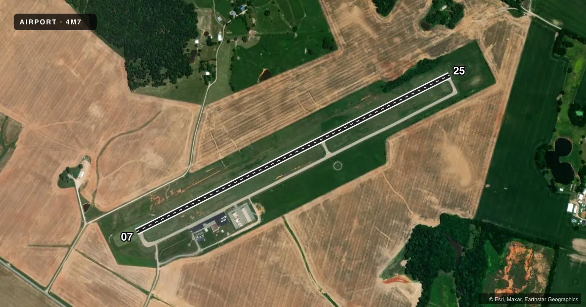
Runways & pattern
Full pagePattern entry · RWY 25
LEFT TRAFFICRunway end performance
| End | TORA | TODA | ASDA | LDA | VGSI | Approach lights | Obstruction |
|---|---|---|---|---|---|---|---|
| 07 | — | — | — | — | PAPI 2-box left(3°) | — | — |
| 25 | — | — | — | — | PAPI 2-box left(3°) | — | — |
Declared distances in feet. TORA = takeoff run available, TODA = takeoff distance, ASDA = accelerate-stop, LDA = landing distance.
Airport sketch
Runways drawn to scale from FAA survey coordinates, rendered over satellite imagery. Not for navigation.
Approaches & charts
Services on the field
Fuel grades, oxygen, maintenance, ramp storage and lighting — as declared to the FAA by the airport operator.
Fuel & services
- Fuel
- 100LLA+
- Oxygen (bottled)
- Not available
- Oxygen (bulk)
- Not available
- Airframe repair
- Minor
- Power plant repair
- Minor
Ramp & ground
- Transient storage
- Tie-down
- Landing fee
- No fee published
- Customs
- Not available
- Lighting schedule
- SEE RMK
- Beacon schedule
- SS-SR
- Beacon
- White / Green (civil land)(WG)
- Wind indicator
- Lighted
- Segmented circle
- Yes
Fuel & FBOs
Cheapest 100LL and Jet A on the field and nearby. Always confirm with the FBO before taxi.
Airport notes
Surface conditions, obstructions, local procedures, lighting outages and other notes published with each FAA cycle.
General notes
- DEER ON & INVOF ARPT.
- WILDLIFE NEAR ARPT.
- FOR CD CTC MEMPHIS ARTCC AT 901-368-8453/8449.
Lighting notes
- ACTVT REIL RYS 07 & 25; PAPI RYS 07 & 25; MIRL RY 07/25 - CTAF.
Other notes
- OWNERAIRPORT BOARD CHAIRMAN STEVE DILLIHA
- MANAGERLANDLINE
VFR map & nearby airports
VFR sectional. Tap any ICAO chip to open that airport.
Key facts · 4M7
Answer card- ICAO
- 4M7
- Name
- RUSSELLVILLE-LOGAN COUNTY
- Location
- RUSSELLVILLE, KENTUCKY
- Elevation
- 691.7 ft MSL
- Traffic pattern altitude
- 1,691.7 ft MSL (1,000 AGL)
- Control tower
- Non-towered (use CTAF)
- Total runways
- 1
- Longest runway
- 07/25 · 4,500 ft
- Published ILS approaches
- 0
- Published frequencies
- 2
- Magnetic variation
- 4°
- Current flight rules
- VFR
- Current wind
- 300° at 6 kt
- Favored runway now
- RWY 25
Russellville-Logan County Airport is in Russellville, Kentucky. The field elevation is 691.7 ft MSL. It has one runway. Runway 07/25 is 4,500 ft long with asphalt pavement. The airport is non-towered. CTAF and UNICOM are both 122.7.
No ILS approaches are published here. Pattern altitude is not published in the facts. Plan on the standard 1,000 ft AGL for light piston operations unless the current FAA Chart Supplement says otherwise. The on-field FBO is Russellville-Logan County Airport. It carries 100LL and Jet A. The published remarks also note runway end identifier lights, PAPI on both runway ends and medium intensity runway lights that are controlled by CTAF.
For a first-time arrival, the main things to watch are wildlife on and near the airport. Deer are specifically reported in the area. That is worth a careful scan on taxi, takeoff and landing. If you need clearance delivery for an IFR departure, contact Memphis ARTCC using the published phone numbers before you go. Check the current FAA Chart Supplement for any additional local procedures before flying in.