METAR & TAF M21
Current METAR
Observed 10:15Z
KM21 271015Z AUTO 35005KT 10SM CLR 23/21 A2995 RMK AO2 T02250211
- Wind
- 350° @ 5 kt
- Visibility
- 10 SM
- Temp / Dew
- 23°C / 21°C
- Altimeter
- 29.95 inHg
- Clouds
- CLR
- Density alt
- 1,454 ft
- Ceiling
- Unlimited
- Rules
- VFR
Airport info & contacts
Manager on record, flight service, ARTCC, attendance schedule and pattern altitude — published by the FAA and refreshed every 28 days.
Location
- From city
- 2 NM NE
- VFR sectional
- ST LOUIS
- ARTCC
- ZME · MEMPHIS
- NOTAM facility
- LOU (NOTAM-D)
Airport manager
- Name
- ED TACKETT
- Phone
- 270-225-8093
- Address
- 399 AIRPORT RD, GREENVILLE KY 42345
Flight service · Hours
- FSS LOU
- LOUISVILLE1-800-WX-BRIEF
- Attendance
- MON-FRI · 0800-1700
Frequencies
Tap any row to copy the frequency to your clipboard.
Runways & pattern
Full pagePattern entry · RWY 06
LEFT TRAFFICRunway end performance
| End | TORA | TODA | ASDA | LDA | VGSI | Approach lights | Obstruction |
|---|---|---|---|---|---|---|---|
| 06 | — | — | — | — | PAPI 2-box left(4°) | — | 80', trees, 1745' from thr, 417' R of cntrln, slope 19 |
| 24 | 5,000' | 5,000' | 5,000' | 4,600' | PAPI 2-box left(4.5°) | — | 62', road, 1276' from thr, 30' R of cntrln, slope 17 |
Declared distances in feet. TORA = takeoff run available, TODA = takeoff distance, ASDA = accelerate-stop, LDA = landing distance.
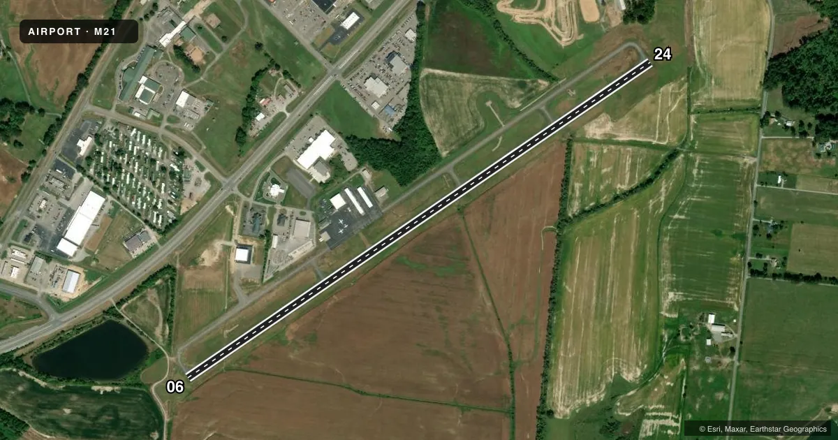
Airport sketch
Runways drawn to scale from FAA survey coordinates, rendered over satellite imagery. Not for navigation.
Approaches & charts
Services on the field
Fuel grades, oxygen, maintenance, ramp storage and lighting — as declared to the FAA by the airport operator.
Fuel & services
- Fuel
- 100LLA+
- Oxygen (bottled)
- Not available
- Oxygen (bulk)
- Not available
- Airframe repair
- Major
- Power plant repair
- Major
- Other services
- AMB
Ramp & ground
- Transient storage
- Tie-down
- Hangar
- Landing fee
- No fee published
- Customs
- Not available
- Lighting schedule
- SEE RMK
- Beacon schedule
- SS-SR
- Beacon
- White / Green (civil land)(WG)
- Wind indicator
- Yes
- Segmented circle
- No
Fuel & FBOs
Cheapest 100LL and Jet A on the field and nearby. Always confirm with the FBO before taxi.
Airport notes
Surface conditions, obstructions, local procedures, lighting outages and other notes published with each FAA cycle.
General notes
- FOR CD CTC CAMPBELL APCH AT 270-798-6441.
Lighting notes
- ACTVT REIL RWY 06 & 24; PAPI RWY 06 & 24; MIRL RWY 06/24 - CTAF.
Fuel notes
- 100LLFUEL AVBL H24 WITH CREDIT CARD.
Approach & departure obstructions
- 2427:1 AT DSPLCD THR.
Other notes
- EXISTED PRIOR TO 1959.
- 1AFT HR - AMGR.
VFR map & nearby airports
VFR sectional. Tap any ICAO chip to open that airport.
Key facts · M21
Answer card- ICAO
- M21
- Name
- MUHLENBERG COUNTY
- Location
- GREENVILLE, KENTUCKY
- Elevation
- 428.2 ft MSL
- Traffic pattern altitude
- 1,428.2 ft MSL (1,000 AGL)
- Control tower
- Non-towered (use CTAF)
- Total runways
- 1
- Longest runway
- 06/24 · 4,999 ft
- Published ILS approaches
- 0
- Published frequencies
- 4
- Magnetic variation
- 3°
- Current flight rules
- VFR
- Current wind
- 350° at 5 kt
- Favored runway now
- RWY 06
Muhlenberg County Airport sits in Greenville, Kentucky. The field elevation is 428.2 ft MSL. It has one runway. Runway 06/24 is 4,999 ft long with asphalt pavement. There is no control tower. The airport uses CTAF 123.0 and UNICOM 123.0. No ILS approaches are published here.
Pattern altitude is not published. Use 1,000 ft AGL for light piston traffic unless the current Chart Supplement says otherwise. The published remarks matter here. Runway end identifier lights, PAPI and medium intensity runway lights are installed on 06/24. 100LL is available 24 hours a day with a credit card. The on-field FBO is Muhlenberg County Airport. It carries AVGAS 100LL and Jet A Prist. After hours, contact the airport manager.
For a first-time arrival, pay attention to the displaced threshold on runway 24. The obstacle clearance slope there is 27 to 1. Clearance delivery is handled through Campbell Approach at 270-798-6441. This is a non-towered field. Listen carefully on CTAF and expect self-announced traffic. If you need the current picture on procedures or any local restrictions, check the current FAA Chart Supplement or call the airport operator before you go.