METAR & TAF 2M0
2M0 does not publish a METAR.
Showing the nearest reporting station: KGDA (MARION-CRITTENDEN COUNTY JAMES C JOHNSON RGNL) · 18.0 NM away. Conditions at 2M0 may differ.
METAR · KGDA
Observed 06:35Z
KGDA 270635Z AUTO 20007KT 10SM RA SCT028 BKN080 OVC100 21/20 A2999 RMK AO2 P0023 T02080197
- Wind
- 200° @ 7 kt
- Visibility
- 10 SM
- Temp / Dew
- 21°C / 20°C
- Altimeter
- 29.99 inHg
- Clouds
- OVC
- Density alt
- 1,358 ft
- Ceiling
- 8,000 ft AGL
- Rules
- VFR
Airport info & contacts
Manager on record, flight service, ARTCC, attendance schedule and pattern altitude — published by the FAA and refreshed every 28 days.
Location
- From city
- 2 NM NE
- VFR sectional
- ST LOUIS
- ARTCC
- ZME · MEMPHIS
- NOTAM facility
- LOU (NOTAM-D)
Airport manager
- Name
- PHILLIP SISK
- Phone
- 270-625-0424
- Address
- 1000 TURNBURY DRIVE, PRINCETON KY 42445
Flight service · Hours
- FSS LOU
- LOUISVILLE1-800-WX-BRIEF
- Attendance
- Unattended
Frequencies
Tap any row to copy the frequency to your clipboard.
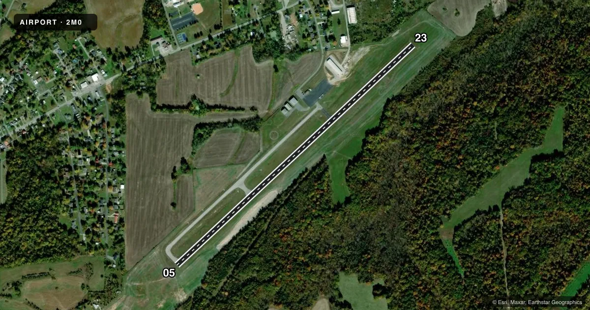
Runways & pattern
Full pagePattern entry · RWY 23
LEFT TRAFFICRunway end performance
| End | TORA | TODA | ASDA | LDA | VGSI | Approach lights | Obstruction |
|---|---|---|---|---|---|---|---|
| 05 | — | — | — | — | PAPI 2-box left(3.25°) | — | 31', berm, 749' from thr, 290' R of cntrln, slope 17 |
| 23 | — | — | — | — | PAPI 2-box left(3°) | — | — |
Declared distances in feet. TORA = takeoff run available, TODA = takeoff distance, ASDA = accelerate-stop, LDA = landing distance.
Airport sketch
Runways drawn to scale from FAA survey coordinates, rendered over satellite imagery. Not for navigation.
Approaches & charts
Services on the field
Fuel grades, oxygen, maintenance, ramp storage and lighting — as declared to the FAA by the airport operator.
Fuel & services
- Fuel
- 100LL
- Oxygen (bottled)
- Not available
- Oxygen (bulk)
- Not available
- Airframe repair
- Not available
- Power plant repair
- Not available
- Other services
- INSTR
Ramp & ground
- Transient storage
- Tie-down
- Landing fee
- No fee published
- Customs
- Not available
- Lighting schedule
- SEE RMK
- Beacon schedule
- SS-SR
- Beacon
- White / Green (civil land)(WG)
- Wind indicator
- Lighted
- Segmented circle
- Yes
Fuel & FBOs
Cheapest 100LL and Jet A on the field and nearby. Always confirm with the FBO before taxi.
Airport notes
Surface conditions, obstructions, local procedures, lighting outages and other notes published with each FAA cycle.
General notes
- FOR CD CTC CAMPBELL APCH AT 270-798-6441.
Lighting notes
- ACTVT REIL RWY 05/23; PAPI RWY 05/23; MIRL RWY 05/23 - CTAF.
Fuel notes
- 100LLFUEL AVBL 24/7 WITH CC.
Approach & departure obstructions
- 05+4 FT BERM 49 FT FROM RWY END, 124 FT L.
- 05ALGAE COVERED & FADED.
- 23ALGAE COVERED & FADED.
Other notes
- EXISTED PRIOR TO 1959.
VFR map & nearby airports
VFR sectional. Tap any ICAO chip to open that airport.
Key facts · 2M0
Answer card- ICAO
- 2M0
- Name
- PRINCETON-CALDWELL COUNTY
- Location
- PRINCETON, KENTUCKY
- Elevation
- 584.3 ft MSL
- Traffic pattern altitude
- 1,584.3 ft MSL (1,000 AGL)
- Control tower
- Non-towered (use CTAF)
- Total runways
- 1
- Longest runway
- 05/23 · 4,099 ft
- Published ILS approaches
- 0
- Published frequencies
- 4
- Magnetic variation
- 3°
- Current flight rules
- VFR
- Current wind
- 200° at 7 kt
- Favored runway now
- RWY 23
Princeton-Caldwell County Airport (2M0) sits in Princeton, Kentucky. Field elevation is 584.3 ft MSL. The airport has one runway. Runway 05/23 is 4,099 ft asphalt. There is no control tower. Pattern altitude is not published, so use the standard 1,000 ft AGL for light piston traffic unless the current Chart Supplement says otherwise.
No ILS approaches are published here. The field does have runway lighting features on 05/23, including REILs, PAPI and medium intensity runway lights that are activated on CTAF. Fuel is available on the field from Princeton-Caldwell County Airport. They carry AVGAS 100LL. Fuel is available 24 hours a day with a credit card. For clearance delivery, Campbell Approach handles that by phone. The published remarks also note faded and algae-covered runway end markings on both ends. They also note a 4-foot berm near the 05 end. That makes a careful look at the runway environment smart on first arrival.
This is a non-towered field, so expect self-announce traffic on CTAF 122.8. Check the current Chart Supplement for any published noise or curfew restrictions before flying into the field. The airport sits at a modest elevation, so density altitude is usually not the main issue. Runway length, lighting and the published obstruction near 05 are the bigger items to brief before you go.