METAR & TAF 8M7
8M7 does not publish a METAR.
Showing the nearest reporting station: KHVC (HOPKINSVILLE-CHRISTIAN COUNTY) · 22.4 NM away. Conditions at 8M7 may differ.
METAR · KHVC
Observed 07:35Z
KHVC 270735Z AUTO 23009KT 10SM VCTS SCT035 BKN055 OVC085 22/22 A2990 RMK A01 LTG DSNT ALQDS
- Wind
- 230° @ 9 kt
- Visibility
- 10 SM
- Temp / Dew
- 22°C / 22°C
- Altimeter
- 29.90 inHg
- Clouds
- OVC
- Density alt
- 1,367 ft
- Ceiling
- 5,500 ft AGL
- Rules
- VFR
Airport info & contacts
Manager on record, flight service, ARTCC, attendance schedule and pattern altitude — published by the FAA and refreshed every 28 days.
Location
- From city
- 2 NM NE
- VFR sectional
- ST LOUIS
- ARTCC
- ZME · MEMPHIS
- NOTAM facility
- LOU (NOTAM-D)
Airport manager
- Name
- MARTHA HAMBY
- Phone
- 270-797-2781
- Address
- P.O BOX 345, DAWSON SPRINGS KY 42408
Flight service · Hours
- FSS LOU
- LOUISVILLE1-800-WX-BRIEF
- Attendance
- Unattended
Frequencies
Tap any row to copy the frequency to your clipboard.
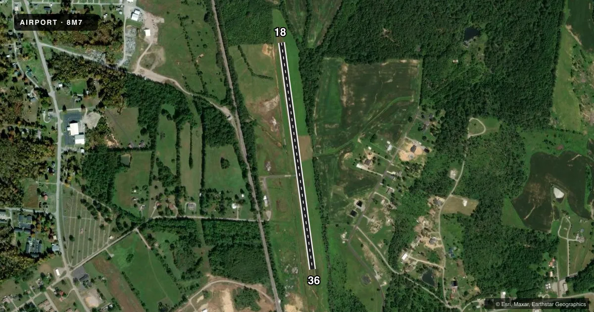
Runways & pattern
Full pagePattern entry · RWY 18
LEFT TRAFFICRunway end performance
| End | TORA | TODA | ASDA | LDA | VGSI | Approach lights | Obstruction |
|---|---|---|---|---|---|---|---|
| 18 | — | — | — | — | — | — | 36', trees, 7' from thr, 105' R of cntrln, slope 0 |
| 36 | — | — | — | — | — | — | 67', trees, 784' from thr, 171' R of cntrln, slope 11 |
Declared distances in feet. TORA = takeoff run available, TODA = takeoff distance, ASDA = accelerate-stop, LDA = landing distance.
Airport sketch
Runways drawn to scale from FAA survey coordinates, rendered over satellite imagery. Not for navigation.
Approaches & charts
Services on the field
Fuel grades, oxygen, maintenance, ramp storage and lighting — as declared to the FAA by the airport operator.
Fuel & services
- Fuel
- Not available
- Oxygen (bottled)
- Not available
- Oxygen (bulk)
- Not available
- Airframe repair
- Not available
- Power plant repair
- Not available
Ramp & ground
- Transient storage
- Hangar
- Landing fee
- No fee published
- Wind indicator
- Yes
- Segmented circle
- Yes
Fuel & FBOs
Cheapest 100LL and Jet A on the field and nearby. Always confirm with the FBO before taxi.
Airport notes
Surface conditions, obstructions, local procedures, lighting outages and other notes published with each FAA cycle.
General notes
- FOR CD CTC CAMPBELL APCH AT 270-798-6441.
- FOR QNS, CTC CITY CLERK, DAWSON SPRINGS KY 270-797-2781.
Approach & departure obstructions
- 1818/36 RY EDGES MARKED BY WHITE PAINTED TIRES.
- 18CTLG OBSTN EXCEEDS A 45 DEG SLP.
Other notes
- VFR ONLY.
- LCTD INSIDE OBJECT FREE AREA 99.14 FT FM RY CNTRLN.
- MANAGERAFT HRS: DAWSON CITY DISPATCH 270-797-2277.
VFR map & nearby airports
VFR sectional. Tap any ICAO chip to open that airport.
Key facts · 8M7
Answer card- ICAO
- 8M7
- Name
- TRADEWATER
- Location
- DAWSON SPRINGS, KENTUCKY
- Elevation
- 405 ft MSL
- Traffic pattern altitude
- 1,405 ft MSL (1,000 AGL)
- Control tower
- Non-towered (use CTAF)
- Total runways
- 1
- Longest runway
- 18/36 · 2,875 ft
- Published ILS approaches
- 0
- Published frequencies
- 1
- Magnetic variation
- 0°
- Current flight rules
- VFR
- Current wind
- 230° at 9 kt
- Favored runway now
- RWY 18
Tradewater Airport sits in Dawson Springs, Kentucky. The field elevation is 405 ft MSL. It has one runway. Runway 18/36 is 2,875 ft long and turf. The runway headings are 172° and 352° magnetic. There is no control tower. CTAF is 122.9.
No ILS approaches are published here. This is VFR only, so plan with the current chart and the weather in mind. The published pattern altitude is not listed in the facts block. Use the current FAA Chart Supplement before you go. The runway edges are marked by white painted tires. There is also a published obstruction near runway 18. The remarks say it exceeds a 45 degree slope from that end. Give yourself a careful look on arrival and departure.
No on-field FBOs are listed. Contact the airport operator directly before arrival if you need fuel or services. For clearance delivery, Campbell Approach is listed in the remarks. After hours contact Dawson City Dispatch. First-time visitors should brief the turf surface. Brief the single-runway setup. Brief the published obstruction near runway 18 before they launch.