METAR & TAF KHVC
Current METAR
Observed 06:15Z
KHVC 270615Z AUTO 35013G24KT 3/4SM TS OVC003 22/22 A2999 RMK A01 LTG DSNT ALQDS
- Wind
- 350° @ 13G24 kt
- Visibility
- 0.75 SM
- Temp / Dew
- 22°C / 22°C
- Altimeter
- 29.99 inHg
- Clouds
- OVC
- Density alt
- 1,452 ft
- Ceiling
- 300 ft AGL
- Rules
- LIFR
Airport info & contacts
Manager on record, flight service, ARTCC, attendance schedule and pattern altitude — published by the FAA and refreshed every 28 days.
Location
- From city
- 2 NM E
- VFR sectional
- ST LOUIS
- ARTCC
- ZME · MEMPHIS
- NOTAM facility
- LOU (NOTAM-D)
Airport manager
- Name
- WILLIAM OUTLAW
- Phone
- 270-889-4157
- Address
- 300 MEMORIAL FIELD DRIVE, HOPKINSVILLE KY 42240
Flight service · Hours
- FSS LOU
- LOUISVILLE1-800-WX-BRIEF
- Attendance
- M-F · 0900-1700
- SA-SU · ON CALL
Frequencies
Tap any row to copy the frequency to your clipboard.
Runways & pattern
Full pagePattern entry · RWY 08
LEFT TRAFFICRunway end performance
| End | TORA | TODA | ASDA | LDA | VGSI | Approach lights | Obstruction |
|---|---|---|---|---|---|---|---|
| 08 | — | — | — | — | PAPI 4-box left(3.5°) | — | 98', trees, 1518' from thr, 431' R of cntrln, slope 13 |
| 26 | — | — | — | — | PAPI 4-box left(4°) | — | 61', trees, 1682' from thr, 395' R of cntrln, slope 24 |
Declared distances in feet. TORA = takeoff run available, TODA = takeoff distance, ASDA = accelerate-stop, LDA = landing distance.
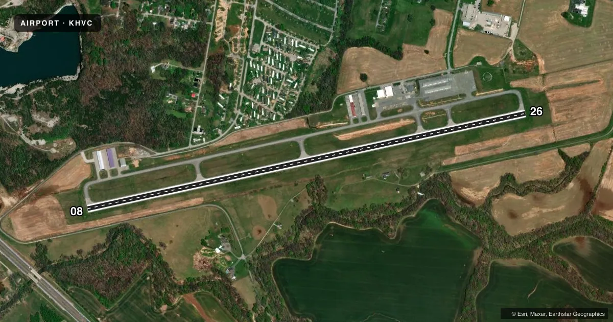
Airport sketch
Runways drawn to scale from FAA survey coordinates, rendered over satellite imagery. Not for navigation.
Approaches & charts
Services on the field
Fuel grades, oxygen, maintenance, ramp storage and lighting — as declared to the FAA by the airport operator.
Fuel & services
- Fuel
- 100LLA+
- Airframe repair
- Minor
- Power plant repair
- Minor
- Other services
- AVNCS,CARGO,INSTR,RNTL
Ramp & ground
- Transient storage
- Tie-down
- Hangar
- Landing fee
- No fee published
- Customs
- Not available
- Lighting schedule
- SEE RMK
- Beacon schedule
- SS-SR
- Beacon
- White / Green (civil land)(WG)
- Wind indicator
- Lighted
- Segmented circle
- Yes
Fuel & FBOs
Cheapest 100LL and Jet A on the field and nearby. Always confirm with the FBO before taxi.
Airport notes
Surface conditions, obstructions, local procedures, lighting outages and other notes published with each FAA cycle.
General notes
- FOR CD CTC CAMPBELL APCH AT 270-798-6441.
Lighting notes
- ACTVT REIL RWY 08 & 26; PAPI RWY 08 & 26; MIRL RWY 08/26 - CTAF
Other notes
- EXISTED PRIOR TO 1959.
- 4270-885-4176
VFR map & nearby airports
VFR sectional. Tap any ICAO chip to open that airport.
Key facts · KHVC
Answer card- ICAO
- KHVC
- Name
- HOPKINSVILLE-CHRISTIAN COUNTY
- Location
- HOPKINSVILLE, KENTUCKY
- Elevation
- 563.6 ft MSL
- Traffic pattern altitude
- 1,563.6 ft MSL (1,000 AGL)
- Control tower
- Non-towered (use CTAF)
- Total runways
- 1
- Longest runway
- 08/26 · 5,505 ft
- Published ILS approaches
- 0
- Published frequencies
- 5
- Magnetic variation
- 1°
- Current flight rules
- LIFR
- Current wind
- 350° at 13 kt
- Favored runway now
- RWY 08
Hopkinsville-Christian County Airport sits in Hopkinsville, Kentucky. The field elevation is 563.6 ft MSL. It has one runway, 08/26, which is 5,505 ft long. There is no control tower. Campbell Approach handles clearance delivery by phone when needed. The published remarks also note that runway end identifier lights, PAPI and medium intensity runway lights are installed on both runway ends.
No ILS approaches are published here. The pattern altitude is not published, so use standard light piston pattern planning at 1,000 ft AGL unless the current Chart Supplement says otherwise. With a single asphalt runway and no tower, this is a straightforward non-towered stop. Stay sharp on CTAF 122.8. The same frequency is listed for UNICOM.
Hopkinsville-Christian County Airport is the on-field FBO. It carries 100LL, Jet A and Jet A Prist. If you need current service details, call the airport at (270) 887-4157. The published remarks also list another airport contact number, 270-885-4176. For a first-time arrival, the main things to verify are runway lighting status, any local traffic flow and current ATC coordination through Campbell Approach.