METAR & TAF 0M5
0M5 does not publish a METAR.
Showing the nearest reporting station: KPHT (HENRY COUNTY) · 34.0 NM away. Conditions at 0M5 may differ.
METAR · KPHT
Observed 11:35Z
KPHT 271135Z AUTO 09004KT 10SM CLR 22/21 A2994 RMK A01
- Wind
- 090° @ 4 kt
- Visibility
- 10 SM
- Temp / Dew
- 22°C / 21°C
- Altimeter
- 29.94 inHg
- Clouds
- CLR
- Density alt
- 1,752 ft
- Ceiling
- Unlimited
- Rules
- VFR
Airport info & contacts
Manager on record, flight service, ARTCC, attendance schedule and pattern altitude — published by the FAA and refreshed every 28 days.
Location
- From city
- 3 NM NE
- VFR sectional
- ST LOUIS
- ARTCC
- ZME · MEMPHIS
- NOTAM facility
- MKL (NOTAM-D)
Airport manager
- Name
- JEFF FINCHER
- Phone
- 205-496-8130
- Address
- 1005 AIRPORT ROAD, WAVERLY TN 37185
Flight service · Hours
- FSS MKL
- JACKSON1-800-WX-BRIEF
- Attendance
- M-F · 0800-1700
Frequencies
Tap any row to copy the frequency to your clipboard.
Runways & pattern
Full pagePattern entry · RWY 03
LEFT TRAFFICRunway end performance
| End | TORA | TODA | ASDA | LDA | VGSI | Approach lights | Obstruction |
|---|---|---|---|---|---|---|---|
| 03 | — | — | — | — | PAPI 2-box left(3°) | — | 114', tree, 3672' from thr, 237' R of cntrln, slope 30 |
| 21 | — | — | — | — | PAPI 2-box left(3°) | — | 29', tree, 540' from thr, 539' R of cntrln, slope 11 |
Declared distances in feet. TORA = takeoff run available, TODA = takeoff distance, ASDA = accelerate-stop, LDA = landing distance.
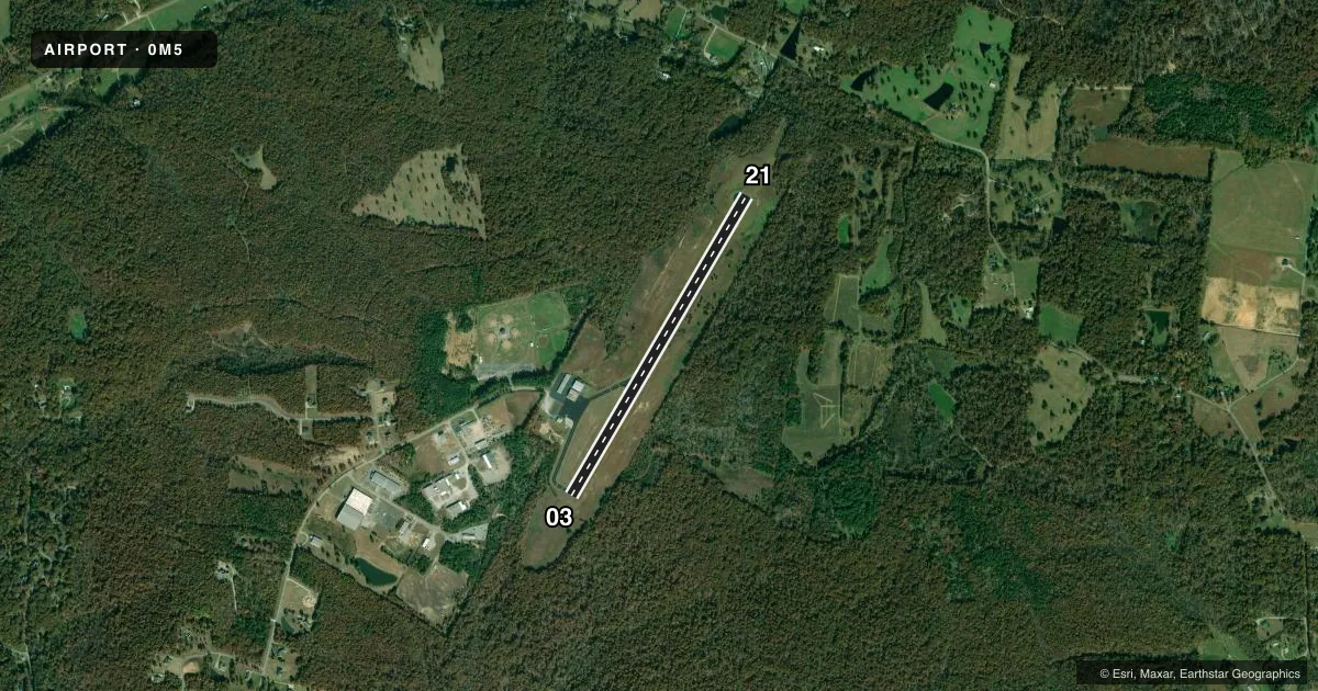
Airport sketch
Runways drawn to scale from FAA survey coordinates, rendered over satellite imagery. Not for navigation.
Approaches & charts
Services on the field
Fuel grades, oxygen, maintenance, ramp storage and lighting — as declared to the FAA by the airport operator.
Fuel & services
- Fuel
- 100LLA+
- Other services
- PAJA
Ramp & ground
- Transient storage
- Tie-down
- Hangar
- Landing fee
- No fee published
- Customs
- Not available
- Lighting schedule
- SEE RMK
- Beacon schedule
- SS-SR
- Beacon
- White / Green (civil land)(WG)
- Wind indicator
- Lighted
- Segmented circle
- Yes
Fuel & FBOs
Cheapest 100LL and Jet A on the field and nearby. Always confirm with the FBO before taxi.
Airport notes
Surface conditions, obstructions, local procedures, lighting outages and other notes published with each FAA cycle.
General notes
- LCL SKYDIVING OPS FRI-SUN.
- WILDLIFE ON & INVOF ARPT.
- FOR CD CTC MEMPHIS ARTCC AT 901-368-8453/8449.
Lighting notes
- ACTVT REIL RWY 03/21 - CTAF.
Fuel notes
- 100LLFUEL AVBL 24/7 WITH CC.
Other notes
- THIS AIRPORT HAS BEEN SURVEYED BY THE NATIONAL GEODETIC SURVEY.
- MANAGER205-496-8130
VFR map & nearby airports
VFR sectional. Tap any ICAO chip to open that airport.
Key facts · 0M5
Answer card- ICAO
- 0M5
- Name
- HUMPHREYS COUNTY
- Location
- WAVERLY, TENNESSEE
- Elevation
- 755.8 ft MSL
- Traffic pattern altitude
- 1,755.8 ft MSL (1,000 AGL)
- Control tower
- Non-towered (use CTAF)
- Total runways
- 1
- Longest runway
- 03/21 · 4,000 ft
- Published ILS approaches
- 0
- Published frequencies
- 2
- Magnetic variation
- 2°
- Current flight rules
- VFR
- Current wind
- 090° at 4 kt
- Favored runway now
- RWY 03
Humphreys County Airport is in Waverly, Tennessee. The field elevation is 755.8 ft MSL. It has one runway. Runway 03/21 is 4,000 ft of asphalt, so it works for light piston traffic and smaller turbine arrivals with normal planning. The airport is non-towered. CTAF and UNICOM are both 122.8.
No ILS approaches are published here. Pattern altitude is not published in the facts, so use the current FAA Chart Supplement before you fly. Runway 03/21 has REIL lighting that is activated on the CTAF frequency. Local skydiving operations occur Friday through Sunday. Wildlife is also reported on and near the airport. Keep a sharp scan on taxi, takeoff and landing.
Humphreys County Airport has one on-field FBO. Humphreys County Airport carries AVGAS 100LL and Jet A. 100LL is available 24 hours a day with a credit card. For clearance delivery, Memphis ARTCC is listed in the remarks. If you are planning a first visit, expect a quiet non-towered field with standard self-announce procedures. Then verify any current local procedures with the airport operator or the current FAA Chart Supplement.