METAR & TAF 0M4
0M4 does not publish a METAR.
Showing the nearest reporting station: KHZD (SGT LEE RUSSELL CARROLL COUNTY) · 17.1 NM away. Conditions at 0M4 may differ.
METAR · KHZD
Observed 12:50Z
KHZD 271250Z AUTO 25005KT 10SM CLR 23/21 A2992 RMK A01
- Wind
- 250° @ 5 kt
- Visibility
- 10 SM
- Temp / Dew
- 23°C / 21°C
- Altimeter
- 29.92 inHg
- Clouds
- CLR
- Density alt
- 1,540 ft
- Ceiling
- Unlimited
- Rules
- VFR
Airport info & contacts
Manager on record, flight service, ARTCC, attendance schedule and pattern altitude — published by the FAA and refreshed every 28 days.
Location
- From city
- 3 NM S
- VFR sectional
- ST LOUIS
- ARTCC
- ZME · MEMPHIS
- NOTAM facility
- MKL (NOTAM-D)
Airport manager
- Name
- RITA HASLAM
- Phone
- 731-584-5343
- Address
- 275 AIRPORT DR, CAMDEN TN 38320
Flight service · Hours
- FSS MKL
- JACKSON1-800-WX-BRIEF
- Attendance
- MON-SAT · 0800-1600
Frequencies
Tap any row to copy the frequency to your clipboard.
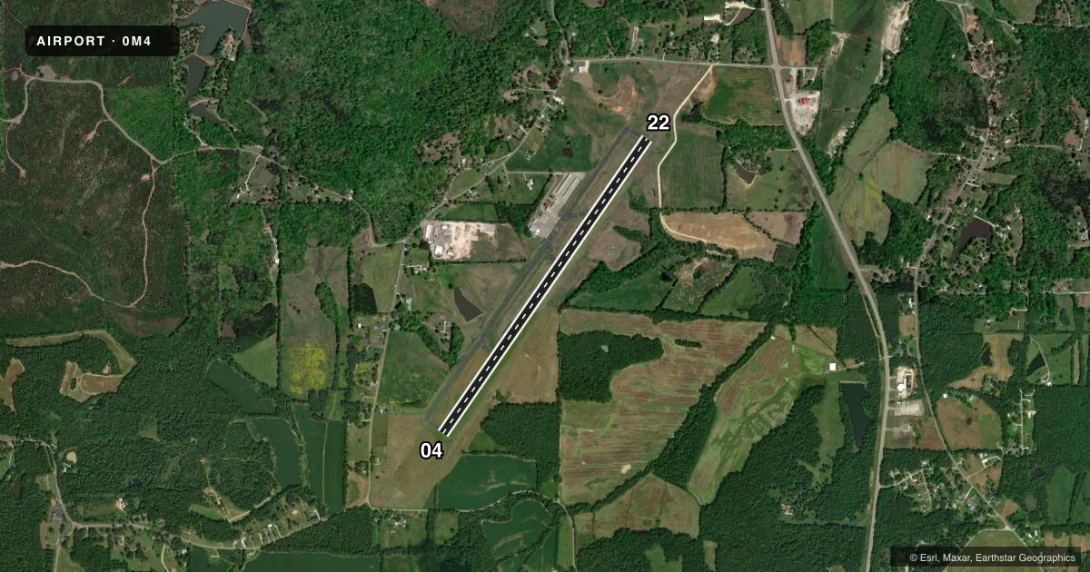
Runways & pattern
Full pagePattern entry · RWY 22
LEFT TRAFFICRunway end performance
| End | TORA | TODA | ASDA | LDA | VGSI | Approach lights | Obstruction |
|---|---|---|---|---|---|---|---|
| 04 | — | — | — | — | PAPI 2-box left(3.5°) | — | 68', trees, 1558' from thr, 295' R of cntrln, slope 19 |
| 22 | — | — | — | — | PAPI 2-box left(3.35°) | — | 73', trees, 1655' from thr, 193' R of cntrln, slope 19 |
Declared distances in feet. TORA = takeoff run available, TODA = takeoff distance, ASDA = accelerate-stop, LDA = landing distance.
Airport sketch
Runways drawn to scale from FAA survey coordinates, rendered over satellite imagery. Not for navigation.
Approaches & charts
Services on the field
Fuel grades, oxygen, maintenance, ramp storage and lighting — as declared to the FAA by the airport operator.
Fuel & services
- Fuel
- 100LLA
Ramp & ground
- Transient storage
- Tie-down
- Landing fee
- No fee published
- Customs
- Not available
- Lighting schedule
- SEE RMK
- Beacon schedule
- SS-SR
- Beacon
- White / Green (civil land)(WG)
- Wind indicator
- Lighted
- Segmented circle
- Yes
Fuel & FBOs
Cheapest 100LL and Jet A on the field and nearby. Always confirm with the FBO before taxi.
Airport notes
Surface conditions, obstructions, local procedures, lighting outages and other notes published with each FAA cycle.
General notes
- FOR CD CTC MEMPHIS ARTCC AT 901-368-8453/8449.
Lighting notes
- ACTVT REIL RWY 04 & 22 - CTAF.
Other notes
- 2UNATNDD HOL.
- 2AFT HR - 731-441-2196.
VFR map & nearby airports
VFR sectional. Tap any ICAO chip to open that airport.
Key facts · 0M4
Answer card- ICAO
- 0M4
- Name
- BENTON COUNTY
- Location
- CAMDEN, TENNESSEE
- Elevation
- 468 ft MSL
- Traffic pattern altitude
- 1,468 ft MSL (1,000 AGL)
- Control tower
- Non-towered (use CTAF)
- Total runways
- 1
- Longest runway
- 04/22 · 5,001 ft
- Published ILS approaches
- 0
- Published frequencies
- 2
- Magnetic variation
- 2°
- Current flight rules
- VFR
- Current wind
- 250° at 5 kt
- Favored runway now
- RWY 22
Benton County Airport sits in Camden, Tennessee. The field elevation is 468 ft MSL. It has one runway. Runway 04/22 is 5,001 ft of asphalt, so plan for a straightforward single-strip operation with no published ILS approaches. The airport is not towered. CTAF and UNICOM are both 122.8.
The pattern altitude is not published. Use the standard 1,000 ft AGL pattern unless the current FAA Chart Supplement says otherwise. That puts the light-piston pattern at 1,468 ft MSL based on the field elevation. Runway 04 and 22 have runway end identifier lights that are activated on CTAF. The airport is unattended on holidays. After hours, contact the number in the Chart Supplement for current access or service details.
Benton County Airport has one on-field FBO. Benton County Airport carries AVGAS_100LL and JET_A_PRIST. If you need current ramp or fuel availability, call the FBO directly at the listed number before departure. For clearance delivery, Memphis ARTCC publishes phone numbers in the Chart Supplement. If you are planning a night arrival or a first trip into the field, brief the lighting and CTAF use before you go.