METAR & TAF KBWG
Current METAR
Observed 09:53Z
KBWG 270953Z AUTO 00000KT 9SM CLR 22/22 A2992 RMK AO2 SLP125 T02220222
- Wind
- 000° @ 0 kt
- Visibility
- 9 SM
- Temp / Dew
- 22°C / 22°C
- Altimeter
- 29.92 inHg
- Clouds
- CLR
- Density alt
- 1,519 ft
- Ceiling
- Unlimited
- Rules
- VFR
Airport info & contacts
Manager on record, flight service, ARTCC, attendance schedule and pattern altitude — published by the FAA and refreshed every 28 days.
Location
- From city
- 2 NM SE
- VFR sectional
- ST LOUIS
- ARTCC
- ZME · MEMPHIS
- NOTAM facility
- BWG (NOTAM-D)
Airport manager
- Name
- SUSAN HARMON
- Phone
- 270-842-1101
- Address
- 1000 WOODHURST ST, BOWLING GREEN KY 42103
Flight service · Hours
- FSS LOU
- LOUISVILLE1-800-WX-BRIEF
- Attendance
- ALL
Frequencies
Tap any row to copy the frequency to your clipboard.
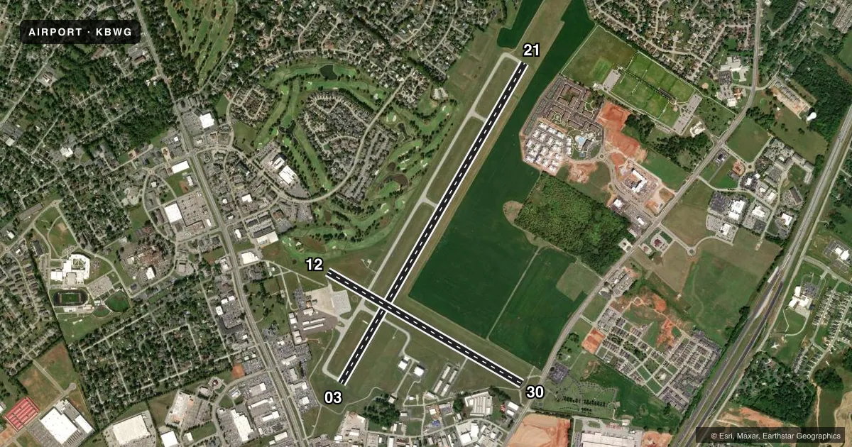
Runways & pattern
Full pagePattern entry · RWY 03
LEFT TRAFFIC| Runway | Heading (°M) | Length | Surface | Traffic |
|---|---|---|---|---|
| 03/21 | 26° / 206° | 6,501 ft | ASPH | Standard L |
| 12/30 | 116° / 296° | 3,956 ft | ASPH | Standard L |
Runway end performance
| End | TORA | TODA | ASDA | LDA | VGSI | Approach lights | Obstruction |
|---|---|---|---|---|---|---|---|
| 03 | 6,500' | 6,500' | 6,500' | 6,500' | PAPI 4-box left(3°) | — | — |
| 21 | 6,500' | 6,500' | 6,500' | 6,500' | PAPI 4-box left(3°) | — | — |
Declared distances in feet. TORA = takeoff run available, TODA = takeoff distance, ASDA = accelerate-stop, LDA = landing distance.
Airport sketch
Runways drawn to scale from FAA survey coordinates, rendered over satellite imagery. Not for navigation.
Approaches & charts
ILS · 1
Services on the field
Fuel grades, oxygen, maintenance, ramp storage and lighting — as declared to the FAA by the airport operator.
Fuel & services
- Fuel
- 100LLA
- Airframe repair
- Major
- Power plant repair
- Major
- Other services
- AFRT,AMB,CARGO,CHTR,INSTR,RNTL,SALES
Ramp & ground
- Transient storage
- Tie-down
- Hangar
- Landing fee
- No fee published
- Customs
- Not available
- Lighting schedule
- SEE RMK
- Beacon schedule
- SS-SR
- Beacon
- White / Green (civil land)(WG)
- Wind indicator
- Lighted
- Segmented circle
- No
Fuel & FBOs
Cheapest 100LL and Jet A on the field and nearby. Always confirm with the FBO before taxi.
Airport notes
Surface conditions, obstructions, local procedures, lighting outages and other notes published with each FAA cycle.
General notes
- BIRDS ON & INVOF ARPT.
- CNL IFR - LOUISVILLE FSS 122.2.
- FOR CD CTC MEMPHIS ARTCC AT 901-368-8453/8449.
Lighting notes
- ACTVT REIL RWY 03, 21; PAPI RWY 03, 21; HIRL RWY 03/21 - CTAF.
Runway surface & condition
- 03/21PCR VALUE: 560/F/C/X/T
- 12/30RWY 12/30 NOT AVBL FOR PART 121/PART 380 OPS WITH SKED PAX CARRYING OPS MORE THAN 9 PAX SEATS AND NON-SKED PAX CARRYING OPS MORE THAN 30 PAX SEATS.
Approach & departure obstructions
- 03FIRST 1300 FT LONGL GRADIENT SLOPE 1.5 PERCENT; STEEPER THAN STD FOR APCH SPD GTR THAN 122 KTS.
- 30+54 FT TREE DIST 860 FT 200 FT L; 15:1 BASED ON DTHR.
Other notes
- EXISTED PRIOR TO 1959.
- OPS WITH MORE THAN 30 PAX SEATS 24 HR PPR - AMGR.
- 12/30LONGL & TRANSVERSE CRACKING; UNEVEN SFC.
VFR map & nearby airports
VFR sectional. Tap any ICAO chip to open that airport.
Key facts · KBWG
Answer card- ICAO
- KBWG
- Name
- BOWLING GREEN-WARREN COUNTY RGNL
- Location
- BOWLING GREEN, KENTUCKY
- Elevation
- 547.2 ft MSL
- Traffic pattern altitude
- 1,547.2 ft MSL (1,000 AGL)
- Control tower
- Non-towered (use CTAF)
- Total runways
- 2
- Longest runway
- 03/21 · 6,501 ft
- Published ILS approaches
- 1
- Published frequencies
- 2
- Magnetic variation
- 4°
- Current flight rules
- VFR
- Current wind
- 000° at 0 kt
- Favored runway now
- –
Bowling Green-Warren County Regional Airport sits in Bowling Green, Kentucky. Field elevation is 547.2 ft MSL. The airport has 2 asphalt runways. The longest is 03/21 at 6,501 ft. There is no control tower. CTAF and UNICOM are both 123.0. One ILS approach is published for Runway 03. Pattern altitude is not published. For light piston traffic, use the standard 1,000 ft AGL pattern unless the current Chart Supplement says otherwise.
On the field, Co-Mar Aviation carries 100LL and Jet A Prist. Ascend Aviation carries 100LL and Jet A. The Bowling Green-Warren County Regional Airport fuel option carries 100LL. Birds are reported on and near the airport, so keep a sharp scan on departure and arrival. Runway 03/21 has PAPI, runway end identifier lights and high intensity lights controlled by CTAF. Runway 03 has a steeper first 1,300 ft gradient than standard for faster approach speeds. Runway 30 has a tree obstacle near the threshold. Runway 12/30 also has cracking and an uneven surface. Runway 12/30 is not available for certain large passenger-carrying operations. For more than 30 passenger seats, 24-hour prior permission from the airport manager is required.