METAR & TAF 3M7
3M7 does not publish a METAR.
Showing the nearest reporting station: KXNX (MUSIC CITY EXEC) · 19.0 NM away. Conditions at 3M7 may differ.
METAR · KXNX
Observed 06:15Z
KXNX 270615Z AUTO 33004KT 10SM FEW060 24/23 A2998 RMK A01
- Wind
- 330° @ 4 kt
- Visibility
- 10 SM
- Temp / Dew
- 24°C / 23°C
- Altimeter
- 29.98 inHg
- Clouds
- FEW
- Density alt
- 2,207 ft
- Ceiling
- Unlimited
- Rules
- VFR
Airport info & contacts
Manager on record, flight service, ARTCC, attendance schedule and pattern altitude — published by the FAA and refreshed every 28 days.
Location
- From city
- 2 NM W
- VFR sectional
- ST LOUIS
- ARTCC
- ZME · MEMPHIS
- NOTAM facility
- 3M7 (NOTAM-D)
Airport manager
- Name
- RICHARD THOMAS
- Phone
- 615-666-6542
- Address
- 1000 AIRPORT RD, LAFAYETTE TN 37083
Flight service · Hours
- FSS BNA
- NASHVILLE1-800-WX-BRIEF
- Attendance
- MON-FRI · 0830-1500
- SAT · 0830-1200
Frequencies
Tap any row to copy the frequency to your clipboard.
Runways & pattern
Full pagePattern entry · RWY 01
LEFT TRAFFICRunway end performance
| End | TORA | TODA | ASDA | LDA | VGSI | Approach lights | Obstruction |
|---|---|---|---|---|---|---|---|
| 01 | 5,200' | 5,200' | 5,200' | 5,000' | PAPI 2-box left(3.5°) | — | 109', tree, 2300' from thr, 372' R of cntrln, slope 19 |
| 19 | 5,200' | 5,200' | 5,000' | 5,000' | PAPI 2-box left(3°) | — | 37', tree, 1016' from thr, 196' R of cntrln, slope 22 |
Declared distances in feet. TORA = takeoff run available, TODA = takeoff distance, ASDA = accelerate-stop, LDA = landing distance.
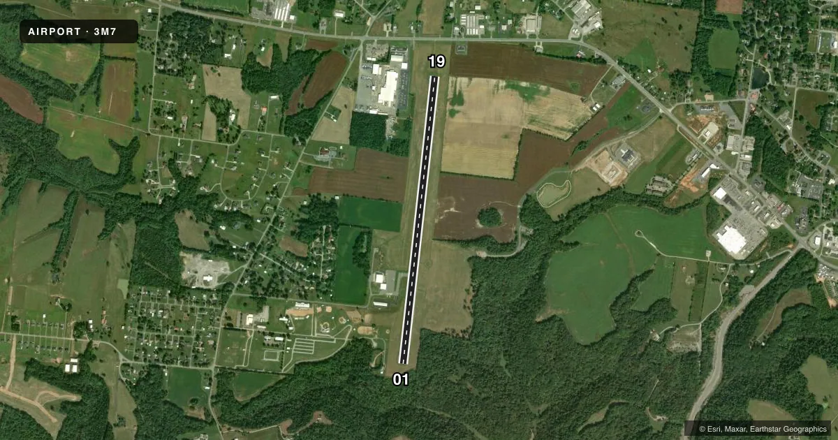
Airport sketch
Runways drawn to scale from FAA survey coordinates, rendered over satellite imagery. Not for navigation.
Approaches & charts
Services on the field
Fuel grades, oxygen, maintenance, ramp storage and lighting — as declared to the FAA by the airport operator.
Fuel & services
- Fuel
- 100LLA+
- Airframe repair
- Minor
- Power plant repair
- Minor
- Other services
- INSTR
Ramp & ground
- Transient storage
- Tie-down
- Landing fee
- No fee published
- Customs
- Not available
- Lighting schedule
- SS-SR
- Beacon schedule
- SS-SR
- Beacon
- White / Green (civil land)(WG)
- Wind indicator
- Lighted
- Segmented circle
- Yes
Fuel & FBOs
Cheapest 100LL and Jet A on the field and nearby. Always confirm with the FBO before taxi.
Airport notes
Surface conditions, obstructions, local procedures, lighting outages and other notes published with each FAA cycle.
General notes
- FOR CD CTC NASHVILLE APCH AT 615-695-4522.
Fuel notes
- 100LLCREDIT CARD SVC H24 AVBL.
Approach & departure obstructions
- 0125:1 FM DTHR.
Other notes
- VFR OPERATIONS ONLY.
VFR map & nearby airports
VFR sectional. Tap any ICAO chip to open that airport.
Key facts · 3M7
Answer card- ICAO
- 3M7
- Name
- LAFAYETTE MUNI
- Location
- LAFAYETTE, TENNESSEE
- Elevation
- 969 ft MSL
- Traffic pattern altitude
- 1,969 ft MSL (1,000 AGL)
- Control tower
- Non-towered (use CTAF)
- Total runways
- 1
- Longest runway
- 01/19 · 5,200 ft
- Published ILS approaches
- 0
- Published frequencies
- 4
- Magnetic variation
- 2°
- Current flight rules
- VFR
- Current wind
- 330° at 4 kt
- Favored runway now
- RWY 01
Lafayette Muni is in Lafayette, Tennessee. The field elevation is 969 ft MSL. It has one runway, 01/19, which is 5,200 ft long. There is no control tower. Pattern altitude is not published, so use the standard 1,000 ft AGL for light piston traffic unless the current Chart Supplement says otherwise. That puts the pattern at about 1,969 ft MSL.
No ILS approaches are published here. This is a VFR-only field per the published remarks, so plan your arrival with that in mind. For clearance delivery, contact Nashville Approach at 615-695-4522. The on-field FBO is Skychaser Aviation. It carries 100LL and Jet A Prist. Credit card self-serve 100LL is available 24 hours.
One operational item stands out. There is a 25 to 1 obstacle clearance slope from the departure threshold of runway 01. That makes the departure end worth a close look during preflight and takeoff planning. With no tower on the field, use CTAF 122.8 for local traffic calls and expect self-announce procedures. If you need current noise or local operating restrictions beyond the published remarks, check the current FAA Chart Supplement before you go.