METAR & TAF M54
Current METAR
Observed 10:10Z
KM54 271010Z AUTO 13004KT 10SM BKN008 OVC011 23/23 A2989 RMK A01
- Wind
- 130° @ 4 kt
- Visibility
- 10 SM
- Temp / Dew
- 23°C / 23°C
- Altimeter
- 29.89 inHg
- Clouds
- OVC
- Density alt
- 1,726 ft
- Ceiling
- 800 ft AGL
- Rules
- IFR
Airport info & contacts
Manager on record, flight service, ARTCC, attendance schedule and pattern altitude — published by the FAA and refreshed every 28 days.
Location
- From city
- 2 NM SW
- VFR sectional
- ST LOUIS
- ARTCC
- ZME · MEMPHIS
- NOTAM facility
- BNA (NOTAM-D)
Airport manager
- Name
- HEATHER BAY
- Phone
- 615-604-7436
- Address
- 200 AVIATION WAY, SUITE 116, LEBANON TN 37090
Flight service · Hours
- FSS BNA
- NASHVILLE1-800-WX-BRIEF
- Attendance
- OCT - FEB · 0700-1700
- MAR - SEP · 0700-1900
Frequencies
Tap any row to copy the frequency to your clipboard.
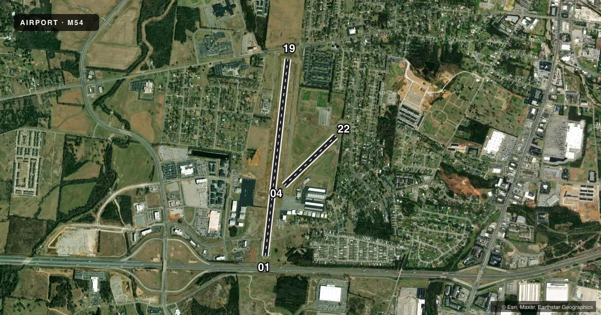
Runways & pattern
Full pagePattern entry · RWY 19
LEFT TRAFFIC| Runway | Heading (°M) | Length | Surface | Traffic |
|---|---|---|---|---|
| 01/19Favored | 5° / 185° | 5,000 ft | ASPH | Standard L |
| 04/22 | 44° / 224° | 1,801 ft | TURF | Standard L |
Runway end performance
| End | TORA | TODA | ASDA | LDA | VGSI | Approach lights | Obstruction |
|---|---|---|---|---|---|---|---|
| 01 | 5,000' | 5,000' | 4,680' | 4,527' | PAPI 2-box left(3.5°) | — | 58', trees, 1268' from thr, 225' R of cntrln, slope 18 |
| 19 | 5,000' | 5,000' | 4,847' | 4,527' | PAPI 2-box left(3°) | — | — |
| 04 | — | — | — | — | — | — | 113', sign, 2500' from thr, 297' R of cntrln, slope 22 |
| 22 | — | — | — | — | — | — | 54', trees, 422' from thr, 184' R of cntrln, slope 7 |
Declared distances in feet. TORA = takeoff run available, TODA = takeoff distance, ASDA = accelerate-stop, LDA = landing distance.
Airport sketch
Runways drawn to scale from FAA survey coordinates, rendered over satellite imagery. Not for navigation.
Approaches & charts
Services on the field
Fuel grades, oxygen, maintenance, ramp storage and lighting — as declared to the FAA by the airport operator.
Fuel & services
- Fuel
- 100LLA
- Oxygen (bottled)
- Low pressure
- Airframe repair
- Major
- Power plant repair
- Major
- Other services
- AFRT,AMB,AVNCS,CARGO,INSTR,RNTL
Ramp & ground
- Transient storage
- Tie-down
- Hangar
- Landing fee
- No fee published
- Customs
- Not available
- Lighting schedule
- SS-SR
- Beacon schedule
- SS-SR
- Beacon
- White / Green (civil land)(WG)
- Wind indicator
- Lighted
- Segmented circle
- Yes
Fuel & FBOs
Cheapest 100LL and Jet A on the field and nearby. Always confirm with the FBO before taxi.
Airport notes
Surface conditions, obstructions, local procedures, lighting outages and other notes published with each FAA cycle.
General notes
- WILDLIFE ON & INVOF ARPT.
- FOR CD CTC NASHVILLE APCH AT 615-695-4522.
- FLT TRNG WI ARPT AREA.
Approach & departure obstructions
- 19CALM WIND RWY.
- 04THR & DTHR MKD 3 FT WHITE CONES.
- 22THR & DTHR MKD 3 FT WHITE CONES.
- 01PAPI OTS INDEF.
Other notes
- SERVICE UP TO 1800 PSI
- 3AFT HR - AMGR.
- 3CLSD EASTER, THANKSGIVING, CHRISTMAS & NEW YEARS DAY.
VFR map & nearby airports
VFR sectional. Tap any ICAO chip to open that airport.
Key facts · M54
Answer card- ICAO
- M54
- Name
- LEBANON MUNI
- Location
- LEBANON, TENNESSEE
- Elevation
- 588 ft MSL
- Traffic pattern altitude
- 1,588 ft MSL (1,000 AGL)
- Control tower
- Non-towered (use CTAF)
- Total runways
- 2
- Longest runway
- 01/19 · 5,000 ft
- Published ILS approaches
- 0
- Published frequencies
- 4
- Magnetic variation
- 2°
- Current flight rules
- IFR
- Current wind
- 130° at 4 kt
- Favored runway now
- RWY 19
Lebanon Muni is in Lebanon, Tennessee. The field elevation is 588.4 ft MSL. It has two runways. The longest is runway 01/19 at 5,000 ft asphalt. Runway 04/22 is 1,801 ft turf. There is no control tower. CTAF and UNICOM are both 122.725. Nashville Approach handles clearance delivery and departure work on 118.4 and 360.7.
No ILS approaches are published here. Pattern altitude is not published, so use the standard 1,000 ft AGL for light piston traffic unless the current Chart Supplement says otherwise. The published remarks matter here. Flight training takes place on the field. Wildlife is reported on and near the airport. Runway 19 is listed as the calm wind runway. Runway 01 and runway 22 have threshold and displaced threshold markers made with 3-foot white cones. The PAPI for runway 01 is out of service indefinitely.
Direct Flight Solutions is on the field. It carries 100LL and Jet A. After hours, the airport manager is on duty. The airport is closed on Easter, Thanksgiving, Christmas and New Year's Day. If you are planning a first visit, expect a non-towered field with training traffic. Check the current Chart Supplement for any current airport notes before you go.