METAR & TAF 0A3
0A3 does not publish a METAR.
Showing the nearest reporting station: KSRB (UPPER CUMBERLAND RGNL) · 14.2 NM away. Conditions at 0A3 may differ.
METAR · KSRB
Observed 11:35Z
KSRB 271135Z AUTO 00000KT 6SM BR FEW065 23/23 A2998 RMK AO2
- Wind
- 000° @ 0 kt
- Visibility
- 6 SM
- Temp / Dew
- 23°C / 23°C
- Altimeter
- 29.98 inHg
- Clouds
- FEW
- Density alt
- 2,230 ft
- Ceiling
- Unlimited
- Rules
- VFR
Airport info & contacts
Manager on record, flight service, ARTCC, attendance schedule and pattern altitude — published by the FAA and refreshed every 28 days.
Location
- From city
- 3 NM NE
- VFR sectional
- ATLANTA
- ARTCC
- ZME · MEMPHIS
- NOTAM facility
- BNA (NOTAM-D)
Airport manager
- Name
- JOHN CARBONARO
- Phone
- 615-597-4940
- Address
- 338 AIRPORT LN, SMITHVILLE TN 37166
Flight service · Hours
- FSS BNA
- NASHVILLE1-800-WX-BRIEF
- Attendance
- MON - FRI · 0800-1600
Frequencies
Tap any row to copy the frequency to your clipboard.
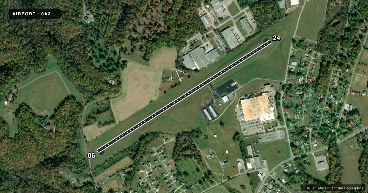
Runways & pattern
Full pagePattern entry · RWY 06
LEFT TRAFFICRunway end performance
| End | TORA | TODA | ASDA | LDA | VGSI | Approach lights | Obstruction |
|---|---|---|---|---|---|---|---|
| 06 | 4,257' | 4,257' | 4,257' | 4,106' | PAPI 2-box left(3°) | — | — |
| 24 | 4,257' | 4,257' | — | 4,106' | PAPI 2-box left(3.5°) | — | 66', trees, 1493' from thr, 335' R of cntrln, slope 19 |
Declared distances in feet. TORA = takeoff run available, TODA = takeoff distance, ASDA = accelerate-stop, LDA = landing distance.
Airport sketch
Runways drawn to scale from FAA survey coordinates, rendered over satellite imagery. Not for navigation.
Approaches & charts
Services on the field
Fuel grades, oxygen, maintenance, ramp storage and lighting — as declared to the FAA by the airport operator.
Fuel & services
- Fuel
- 100LLA+
- Oxygen (bottled)
- Not available
- Oxygen (bulk)
- Not available
- Airframe repair
- Major
- Power plant repair
- Major
Ramp & ground
- Transient storage
- Tie-down
- Landing fee
- No fee published
- Customs
- Not available
- Lighting schedule
- SS-SR
- Beacon schedule
- SS-SR
- Beacon
- White / Green (civil land)(WG)
- Wind indicator
- Lighted
- Segmented circle
- Yes
Fuel & FBOs
Cheapest 100LL and Jet A on the field and nearby. Always confirm with the FBO before taxi.
Airport notes
Surface conditions, obstructions, local procedures, lighting outages and other notes published with each FAA cycle.
General notes
- FOR CD CTC MEMPHIS ARTCC AT 901-368-8453/8449.
Approach & departure obstructions
- 24REIL OTS INDEF.
Other notes
- THIS AIRPORT HAS BEEN SURVEYED BY THE NATIONAL GEODETIC SURVEY.
- AUTOMATED UNICOM; 3 CLICKS ABBREVIATED WX, 4 CLICKS FULL WX.
- OWNERHUNTER HENDRIXSON
- MANAGER615-597-4940.
- OWNER615-597-4745
VFR map & nearby airports
VFR sectional. Tap any ICAO chip to open that airport.
Key facts · 0A3
Answer card- ICAO
- 0A3
- Name
- SMITHVILLE MUNI
- Location
- SMITHVILLE, TENNESSEE
- Elevation
- 1,084.3 ft MSL
- Traffic pattern altitude
- 2,084.3 ft MSL (1,000 AGL)
- Control tower
- Non-towered (use CTAF)
- Total runways
- 1
- Longest runway
- 06/24 · 4,257 ft
- Published ILS approaches
- 0
- Published frequencies
- 2
- Magnetic variation
- 4°
- Current flight rules
- VFR
- Current wind
- 000° at 0 kt
- Favored runway now
- –
SMITHVILLE MUNI (0A3) sits in Smithville, Tennessee. The field elevation is 1,084.3 ft MSL. It has one runway, 06/24, which is 4,257 ft long and paved with asphalt. The airport is non-towered. CTAF and UNICOM are both 122.8. No ILS approaches are published here.
The published pattern altitude is not listed. For light piston operations, use the standard 1,000 ft AGL pattern unless the current Chart Supplement says otherwise. That puts the pattern at about 2,084.3 ft MSL based on the field elevation. Runway headings are 58° and 238° magnetic.
Smithville Municipal Airport is the on-field FBO. It carries 100LL and Jet A. Call the field directly at (615) 597-4940 for current service details. Published remarks note that runway end identifier lights for runway 24 are out of service indefinitely. Automated UNICOM is available with weather by radio. For clearance delivery, contact Memphis ARTCC before departure if you need IFR services. The airport owner is Hunter Hendrixson. The manager phone number is also published in the Chart Supplement. Check the current FAA Chart Supplement for any updated lighting, operational, or local procedures before you go.