METAR & TAF KSRB
Current METAR
Observed 03:15Z
KSRB 270315Z AUTO 00000KT 7SM SCT050 BKN060 BKN075 26/26 A2995 RMK AO2
- Wind
- 000° @ 0 kt
- Visibility
- 7 SM
- Temp / Dew
- 26°C / 26°C
- Altimeter
- 29.95 inHg
- Clouds
- BKN
- Density alt
- 2,554 ft
- Ceiling
- 6,000 ft AGL
- Rules
- VFR
Airport info & contacts
Manager on record, flight service, ARTCC, attendance schedule and pattern altitude — published by the FAA and refreshed every 28 days.
Location
- From city
- 9 NM NW
- VFR sectional
- ST LOUIS
- ARTCC
- ZME · MEMPHIS
- NOTAM facility
- BNA (NOTAM-D)
Airport manager
- Name
- DEAN SELBY
- Phone
- 931-739-7000
- Address
- 750 AIRPORT RD, SPARTA TN 38583
Flight service · Hours
- FSS BNA
- NASHVILLE1-800-WX-BRIEF
- Attendance
- MON-SAT · 0700-1900
- SUN · 1000-1900
Frequencies
Tap any row to copy the frequency to your clipboard.
Runways & pattern
Full pagePattern entry · RWY 04
LEFT TRAFFICRunway end performance
| End | TORA | TODA | ASDA | LDA | VGSI | Approach lights | Obstruction |
|---|---|---|---|---|---|---|---|
| 04 | 6,704' | 6,704' | 6,000' | 6,000' | PAPI 4-box left(3°) | RLLS | 74', tree, 3011' from thr, 299' R of cntrln, slope 37 |
| 22 | 6,704' | 6,704' | 6,704' | 6,000' | PAPI 4-box left(3°) | — | — |
Declared distances in feet. TORA = takeoff run available, TODA = takeoff distance, ASDA = accelerate-stop, LDA = landing distance.
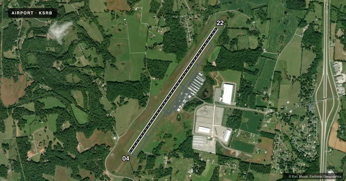
Airport sketch
Runways drawn to scale from FAA survey coordinates, rendered over satellite imagery. Not for navigation.
Approaches & charts
ILS · 1
Services on the field
Fuel grades, oxygen, maintenance, ramp storage and lighting — as declared to the FAA by the airport operator.
Fuel & services
- Fuel
- 100LLA+
- Oxygen (bottled)
- Low pressure
- Airframe repair
- Major
- Power plant repair
- Major
- Other services
- AFRT,AMB,AVNCS,CARGO,INSTR,RNTL,SALES
Ramp & ground
- Transient storage
- Tie-down
- Hangar
- Landing fee
- No fee published
- Customs
- Not available
- Lighting schedule
- SEE RMK
- Beacon schedule
- SS-SR
- Beacon
- White / Green (civil land)(WG)
- Wind indicator
- Lighted
- Segmented circle
- Yes
Fuel & FBOs
Cheapest 100LL and Jet A on the field and nearby. Always confirm with the FBO before taxi.
Airport notes
Surface conditions, obstructions, local procedures, lighting outages and other notes published with each FAA cycle.
General notes
- FOR CD CTC MEMPHIS ARTCC AT 901-368-8453/8449.
Lighting notes
- ACTVT RLLS RWY 04; REIL RWY 04 & 22; HIRL RWY 04/22 - CTAF.
Other notes
- 1AFT HR - 931-739-7000 EXT 7.
VFR map & nearby airports
VFR sectional. Tap any ICAO chip to open that airport.
Key facts · KSRB
Answer card- ICAO
- KSRB
- Name
- UPPER CUMBERLAND RGNL
- Location
- SPARTA, TENNESSEE
- Elevation
- 1,025.2 ft MSL
- Traffic pattern altitude
- 2,025.2 ft MSL (1,000 AGL)
- Control tower
- Non-towered (use CTAF)
- Total runways
- 1
- Longest runway
- 04/22 · 6,704 ft
- Published ILS approaches
- 1
- Published frequencies
- 2
- Magnetic variation
- 3°
- Current flight rules
- VFR
- Current wind
- 000° at 0 kt
- Favored runway now
- –
Upper Cumberland Rgnl Airport sits in Sparta, Tennessee. Field elevation is 1,025.2 ft MSL. It has one runway, 04/22, with a length of 6,704 ft. There is no control tower. CTAF and UNICOM are both 122.975.
The airport has one ILS approach to runway 04. Runway 04/22 is asphalt. Runway 04 has activated runway lights. Runway 04 and 22 have runway end identifier lights. The runway also has high intensity lighting. For clearance delivery, contact Memphis Air Route Traffic Control Center at 901-368-8453 or 901-368-8449.
Pattern altitude is not published in the facts. Use the standard 1,000 ft AGL pattern unless the current Chart Supplement says otherwise. That puts the light piston pattern at about 2,025 ft MSL based on the field elevation. The on-field FBO is Upper Cumberland Regional Jet Center. It carries 100LL and Jet A Prist. After hours, call 931-739-7000 extension 7. If you are new to the field, plan for an uncontrolled airport with one long runway and an ILS on 04. Check the current Chart Supplement for any published noise or curfew restrictions before flying into the field.