METAR & TAF 1A7
1A7 does not publish a METAR.
Showing the nearest reporting station: KSRB (UPPER CUMBERLAND RGNL) · 21.1 NM away. Conditions at 1A7 may differ.
METAR · KSRB
Observed 11:35Z
KSRB 271135Z AUTO 00000KT 6SM BR FEW065 23/23 A2998 RMK AO2
- Wind
- 000° @ 0 kt
- Visibility
- 6 SM
- Temp / Dew
- 23°C / 23°C
- Altimeter
- 29.98 inHg
- Clouds
- FEW
- Density alt
- 1,527 ft
- Ceiling
- Unlimited
- Rules
- VFR
Airport info & contacts
Manager on record, flight service, ARTCC, attendance schedule and pattern altitude — published by the FAA and refreshed every 28 days.
Location
- From city
- 3 NM NE
- VFR sectional
- ST LOUIS
- ARTCC
- ZME · MEMPHIS
- NOTAM facility
- BNA (NOTAM-D)
Airport manager
- Name
- JIM YOUNG
- Phone
- 931-397-6643
- Address
- 153 WARD LANE, GAINESBORO TN 38562
Flight service · Hours
- FSS BNA
- NASHVILLE1-800-WX-BRIEF
- Attendance
- Unattended
Frequencies
Tap any row to copy the frequency to your clipboard.
Runways & pattern
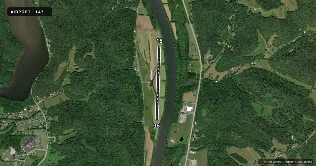
Full pagePattern entry · RWY 18
LEFT TRAFFICAirport sketch
Runways drawn to scale from FAA survey coordinates, rendered over satellite imagery. Not for navigation.
Approaches & charts
Services on the field
Fuel grades, oxygen, maintenance, ramp storage and lighting — as declared to the FAA by the airport operator.
Fuel & services
- Fuel
- Not available
Ramp & ground
- Transient storage
- Not published
- Landing fee
- No fee published
- Customs
- Not available
- Wind indicator
- Yes
- Segmented circle
- Yes
Fuel & FBOs
Cheapest 100LL and Jet A on the field and nearby. Always confirm with the FBO before taxi.
Airport notes
Surface conditions, obstructions, local procedures, lighting outages and other notes published with each FAA cycle.
General notes
- HIGH TRRN ALL QUADS.
- FOR CD CTC MEMPHIS ARTCC AT 901-368-8453/8449.
Other notes
- VFR OPS ONLY.
VFR map & nearby airports
VFR sectional. Tap any ICAO chip to open that airport.
Key facts · 1A7
Answer card- ICAO
- 1A7
- Name
- JACKSON COUNTY
- Location
- GAINESBORO, TENNESSEE
- Elevation
- 517.3 ft MSL
- Traffic pattern altitude
- 1,517.3 ft MSL (1,000 AGL)
- Control tower
- Non-towered (use CTAF)
- Total runways
- 1
- Longest runway
- 18/36 · 3,497 ft
- Published ILS approaches
- 0
- Published frequencies
- 1
- Magnetic variation
- 2°
- Current flight rules
- VFR
- Current wind
- 000° at 0 kt
- Favored runway now
- –
Jackson County Airport (1A7) sits near Gainesboro, Tennessee. Field elevation is 517.3 ft MSL. The airport has one runway. Runway 18/36 is 3,497 ft long with asphalt pavement. Magnetic headings are 182° and 2°. There is no control tower. CTAF is 122.9.
No ILS approaches are published here. Published remarks say this field is VFR only. They also call out high terrain in all quadrants. Plan your arrival and departure with terrain clearance in mind. For clearance delivery, contact Memphis ARTCC at 901-368-8453 or 901-368-8449.
Pattern altitude is not published. Use the standard 1,000 ft AGL pattern for light piston aircraft unless the current FAA Chart Supplement says otherwise. That puts the pattern at about 1,517.3 ft MSL based on the listed field elevation.
No on-field FBOs are listed. Contact the airport operator directly or call the field on CTAF for current services before you go. If you are planning a first visit, treat this as a small non-towered strip with terrain nearby. Keep your arrival briefed. Stay alert for local traffic. Verify current airport data before takeoff.