METAR & TAF KCSV
Current METAR
Observed 12:32Z
KCSV 271232Z AUTO 32008KT 10SM FEW007 BKN010 OVC047 24/23 A3001 RMK AO2 T02390228
- Wind
- 320° @ 8 kt
- Visibility
- 10 SM
- Temp / Dew
- 24°C / 23°C
- Altimeter
- 30.01 inHg
- Clouds
- OVC
- Density alt
- 3,302 ft
- Ceiling
- 1,000 ft AGL
- Rules
- MVFR
Airport info & contacts
Manager on record, flight service, ARTCC, attendance schedule and pattern altitude — published by the FAA and refreshed every 28 days.
Location
- From city
- 3 NM W
- VFR sectional
- ATLANTA
- ARTCC
- ZTL · ATLANTA
- NOTAM facility
- CSV (NOTAM-D)
Airport manager
- Name
- JOHNNA MCCOY
- Phone
- 931-979-0731
- Address
- 2409 SPARTA HIGHWAY, CROSSVILLE TN 38555
Flight service · Hours
- FSS BNA
- NASHVILLE1-800-WX-BRIEF
- Attendance
- 0800-DARK
Frequencies
Tap any row to copy the frequency to your clipboard.
Runways & pattern
Full pagePattern entry · RWY 26
LEFT TRAFFICRunway end performance
| End | TORA | TODA | ASDA | LDA | VGSI | Approach lights | Obstruction |
|---|---|---|---|---|---|---|---|
| 08 | — | — | — | — | VASI 4-box right(3°) | — | — |
| 26 | — | — | — | — | PAPI 4-box left(3°) | — | — |
Declared distances in feet. TORA = takeoff run available, TODA = takeoff distance, ASDA = accelerate-stop, LDA = landing distance.
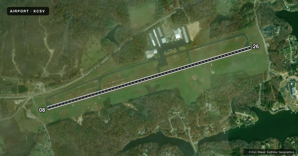
Airport sketch
Runways drawn to scale from FAA survey coordinates, rendered over satellite imagery. Not for navigation.
Approaches & charts
ILS · 1
Services on the field
Fuel grades, oxygen, maintenance, ramp storage and lighting — as declared to the FAA by the airport operator.
Fuel & services
- Fuel
- 100LLA+
- Airframe repair
- Major
- Power plant repair
- Major
- Other services
- INSTR,RNTL,SALES
Ramp & ground
- Transient storage
- Tie-down
- Landing fee
- No fee published
- Customs
- Not available
- Lighting schedule
- SEE RMK
- Beacon schedule
- SS-SR
- Beacon
- White / Green (civil land)(WG)
- Wind indicator
- Lighted
- Segmented circle
- Yes
Fuel & FBOs
Cheapest 100LL and Jet A on the field and nearby. Always confirm with the FBO before taxi.
Airport notes
Surface conditions, obstructions, local procedures, lighting outages and other notes published with each FAA cycle.
General notes
- FOR CD IF UNA TO CTC ON FSS FREQ, CTC ATLANTA ARTCC AT 770-210-7692.
Lighting notes
- HIRL RWY 08/26 PRESET LOW INTST; INCR INTST - CTAF.
Approach & departure obstructions
- 26PAPI UNUSBL BYD 8 DEGS RIGHT OF CNTRLN.
Other notes
- 1CLSD THANKSGIVING & CHRISTMAS.
- 1AFT HR - 931-267-5214.
- MANAGERJOHNNA MCCOY
VFR map & nearby airports
VFR sectional. Tap any ICAO chip to open that airport.
Key facts · KCSV
Answer card- ICAO
- KCSV
- Name
- CROSSVILLE MEML-WHITSON FLD
- Location
- CROSSVILLE, TENNESSEE
- Elevation
- 1,881.7 ft MSL
- Traffic pattern altitude
- 2,881.7 ft MSL (1,000 AGL)
- Control tower
- Non-towered (use CTAF)
- Total runways
- 1
- Longest runway
- 08/26 · 5,423 ft
- Published ILS approaches
- 1
- Published frequencies
- 2
- Magnetic variation
- 2°
- Current flight rules
- MVFR
- Current wind
- 320° at 8 kt
- Favored runway now
- RWY 26
Crossville Meml-Whitson Fld sits in Crossville, Tennessee. The field elevation is 1,881.7 ft MSL. KCSV has one runway, 08/26, with a length of 5,423 ft. There is no control tower. CTAF and UNICOM are both 122.7. The published pattern altitude is not given in the facts, so use the current Chart Supplement before you go. For light piston traffic, standard 1,000 ft AGL is often used when no published pattern is listed. Verify that before flight.
An ILS is available to runway 26. The runway headings are magnetic. Azure Flight Support is on the field. It carries AVGAS 100LL and Jet A Prist. The airport remarks also note that the runway lights on 08/26 start at low intensity. You can increase them on CTAF. Runway 26 has a PAPI, but it is unusable beyond 8 degrees right of centerline.
This is a non-towered field, so plan your arrival calls early and keep the pattern tight. Crossville sits on the Cumberland Plateau, so density altitude can matter in warm weather. Check the current FAA Chart Supplement for any published noise or curfew restrictions before flying into the field. The airport is closed on Thanksgiving and Christmas.