METAR & TAF KFWC
Current METAR
Observed 15:15Z
KFWC 271515Z AUTO 00000KT 10SM CLR 28/22 A2988 RMK AO2 T02790217
- Wind
- 000° @ 0 kt
- Visibility
- 10 SM
- Temp / Dew
- 28°C / 22°C
- Altimeter
- 29.88 inHg
- Clouds
- CLR
- Density alt
- 2,148 ft
- Ceiling
- Unlimited
- Rules
- VFR
Airport info & contacts
Manager on record, flight service, ARTCC, attendance schedule and pattern altitude — published by the FAA and refreshed every 28 days.
Location
- From city
- 2 NM W
- VFR sectional
- ST LOUIS
- ARTCC
- ZKC · KANSAS CITY
- NOTAM facility
- FWC (NOTAM-D)
Airport manager
- Name
- TRAVIS WILLIAMS
- Phone
- 618-842-9587
- Address
- CITY HALL 109 NE 2ND ST, FAIRFIELD IL 62837
Flight service · Hours
- FSS STL
- SAINT LOUIS1-800-WX-BRIEF
- Attendance
- 0800-1600
Frequencies
Tap any row to copy the frequency to your clipboard.
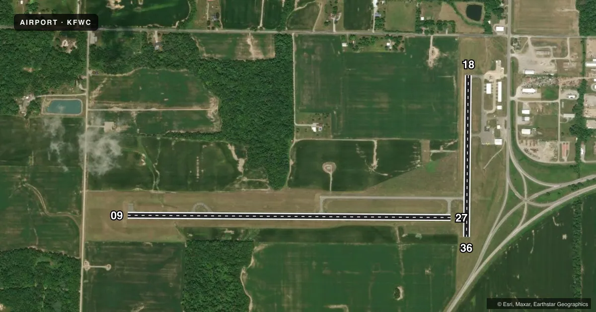
Runways & pattern
Full pagePattern entry · RWY 09
LEFT TRAFFIC| Runway | Heading (°M) | Length | Surface | Traffic |
|---|---|---|---|---|
| 09/27 | 89° / 269° | 4,000 ft | ASPH | Standard L |
| 18/36 | 180° / 0° | 1,999 ft | ASPH | Standard L |
Runway end performance
| End | TORA | TODA | ASDA | LDA | VGSI | Approach lights | Obstruction |
|---|---|---|---|---|---|---|---|
| 09 | — | — | — | — | PSIL(3°) | — | — |
| 27 | — | — | — | — | PSIL(3°) | — | — |
| 36 | — | — | — | — | — | — | 14', road, 323' from thr, 136' R of cntrln, slope 8 |
Declared distances in feet. TORA = takeoff run available, TODA = takeoff distance, ASDA = accelerate-stop, LDA = landing distance.
Airport sketch
Runways drawn to scale from FAA survey coordinates, rendered over satellite imagery. Not for navigation.
Approaches & charts
Services on the field
Fuel grades, oxygen, maintenance, ramp storage and lighting — as declared to the FAA by the airport operator.
Fuel & services
- Fuel
- 100LLA
- Oxygen (bottled)
- Not available
- Oxygen (bulk)
- Not available
- Other services
- AGRI
Ramp & ground
- Transient storage
- Tie-down
- Landing fee
- No fee published
- Customs
- Not available
- Lighting schedule
- SEE RMK
- Beacon schedule
- SS-SR
- Beacon
- White / Green (civil land)(WG)
- Wind indicator
- Lighted
- Segmented circle
- No
Fuel & FBOs
Cheapest 100LL and Jet A on the field and nearby. Always confirm with the FBO before taxi.
Airport notes
Surface conditions, obstructions, local procedures, lighting outages and other notes published with each FAA cycle.
General notes
- FOR CD CTC KANSAS CITY ARTCC AT 913-254-8508.
Lighting notes
- MIRL RY 18/36 PRESET ON LOW INTST; TO INCR INTST & ACTVT MIRL RY 09/27; REIL RY 09 - 123.05.
Approach & departure obstructions
- 18RWY 18 MARKING FADED.
- 36RWY 36 MARKING FADED.
- 09PSIL UNUSBL BYD 6 DEGS RIGHT AND LEFT OF CNTRLN.
- 27PSIL UNUSBL BYD 6 DEGS RIGHT AND LEFT OF CNTRLN.
- 3618/36 APPROACH SLOPE IS 23:1 TO RUNWAY 36 END.
Other notes
- 1FOR ATTENDANT OTR HRS CALL NUMBER LOCATED AT FBO ENTRANCE.
VFR map & nearby airports
VFR sectional. Tap any ICAO chip to open that airport.
Key facts · KFWC
Answer card- ICAO
- KFWC
- Name
- FAIRFIELD MUNI
- Location
- FAIRFIELD, ILLINOIS
- Elevation
- 434.4 ft MSL
- Traffic pattern altitude
- 1,434.4 ft MSL (1,000 AGL)
- Control tower
- Non-towered (use CTAF)
- Total runways
- 2
- Longest runway
- 09/27 · 4,000 ft
- Published ILS approaches
- 0
- Published frequencies
- 2
- Magnetic variation
- 1°
- Current flight rules
- VFR
- Current wind
- 000° at 0 kt
- Favored runway now
- –
Fairfield Muni is in Fairfield, Illinois. The field elevation is 434.4 ft MSL. It has two asphalt runways. The longest is 4,000 ft on 09/27. There is no control tower, so expect non-towered traffic procedures on CTAF 123.05. No ILS approaches are published here.
The published pattern altitude is not listed in the facts. Use the current FAA Chart Supplement before you go. The airport sits in open southern Illinois terrain, so runway alignment and wind matter more than elevation. Runway 18 and Runway 36 both have faded markings. The PAPI on 09 and 27 is only usable within 6 degrees left or right of centerline. The 18/36 runway lights are preset to low intensity. Use 123.05 to increase intensity for 09/27 lighting.
Fairfield Municipal Airport is the on-field FBO. It carries AVGAS 100LL and Jet A. Call the FBO directly at (618) 842-9587 for current service details or after-hours help. One operational note stands out. The approach slope for Runway 18/36 is 23 to 1 to the Runway 36 end. That is worth checking before you plan a low approach or short final on that side.