METAR & TAF KPCD
Current METAR
Observed 16:15Z
KPCD 271615Z AUTO 22010KT 10SM 32/23 A2990 RMK AO2 T03200228
- Wind
- 220° @ 10 kt
- Visibility
- 10 SM
- Temp / Dew
- 32°C / 23°C
- Altimeter
- 29.90 inHg
- Clouds
- Clear
- Density alt
- 2,527 ft
- Ceiling
- Unlimited
- Rules
- VFR
Airport info & contacts
Manager on record, flight service, ARTCC, attendance schedule and pattern altitude — published by the FAA and refreshed every 28 days.
Location
- From city
- 9 NM N
- VFR sectional
- ST LOUIS
- ARTCC
- ZKC · KANSAS CITY
- NOTAM facility
- STL (NOTAM-D)
Airport manager
- Name
- BARBARA MAXWELL
- Phone
- 573-605-1856
- Address
- 1856 HWY H, PERRYVILLE MO 63775
Flight service · Hours
- FSS STL
- SAINT LOUIS1-800-WX-BRIEF
- Attendance
- MON-FRI · 0700-1600
Frequencies
Tap any row to copy the frequency to your clipboard.
Runways & pattern
Full pagePattern entry · RWY 20
LEFT TRAFFICRunway end performance
| End | TORA | TODA | ASDA | LDA | VGSI | Approach lights | Obstruction |
|---|---|---|---|---|---|---|---|
| 02 | 6,483' | 6,483' | 6,483' | 6,483' | PAPI 4-box left(3°) | — | 16', road, 570' from thr, 250' R of cntrln, slope 23 |
| 20 | 6,483' | 6,483' | 6,483' | 6,483' | PAPI 4-box left(3°) | — | — |
Declared distances in feet. TORA = takeoff run available, TODA = takeoff distance, ASDA = accelerate-stop, LDA = landing distance.
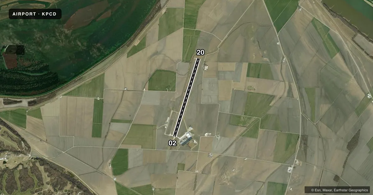
Airport sketch
Runways drawn to scale from FAA survey coordinates, rendered over satellite imagery. Not for navigation.
Approaches & charts
Services on the field
Fuel grades, oxygen, maintenance, ramp storage and lighting — as declared to the FAA by the airport operator.
Fuel & services
- Fuel
- 100LLA
- Oxygen (bottled)
- Not available
- Oxygen (bulk)
- Not available
- Airframe repair
- Major
- Power plant repair
- Major
- Other services
- AVNCS,CHTR,INSTR,RNTL
Ramp & ground
- Transient storage
- Tie-down
- Hangar
- Landing fee
- No fee published
- Customs
- Not available
- Lighting schedule
- SEE RMK
- Beacon schedule
- SS-SR
- Beacon
- White / Green (civil land)(WG)
- Wind indicator
- Lighted
- Segmented circle
- Yes
Fuel & FBOs
Cheapest 100LL and Jet A on the field and nearby. Always confirm with the FBO before taxi.
Airport notes
Surface conditions, obstructions, local procedures, lighting outages and other notes published with each FAA cycle.
General notes
- GEN AVN FACILITIES, FBO & FUEL LOCATED ON W SIDE OF RWY.
- FOR CD CTC KANSAS CITY ARTCC AT 913-254-8508.
Lighting notes
- ACTVT MIRL RY 02/20, PAPI RY 20, REIL RYS 02 & 20 - CTAF.
Fuel notes
- 100LLX2 PUMPS 100LL SELF SERVICE WITH CREDIT CARD - FULL SERVICE JETA FROM TRUCK - CALLOUT FEE $125
Approach & departure obstructions
- 0250:1 TO DSPLCD THLD.
Other notes
- PRVD EACH APCH IS MAINT FOR MIN 20:1 GLIDE SLOPE & TRSNL SFC MAINT FOR 7:1 SLOPE.
VFR map & nearby airports
VFR sectional. Tap any ICAO chip to open that airport.
Key facts · KPCD
Answer card- ICAO
- KPCD
- Name
- PERRYVILLE RGNL
- Location
- PERRYVILLE, MISSOURI
- Elevation
- 372.6 ft MSL
- Traffic pattern altitude
- 1,372.6 ft MSL (1,000 AGL)
- Control tower
- Non-towered (use CTAF)
- Total runways
- 1
- Longest runway
- 02/20 · 6,483 ft
- Published ILS approaches
- 0
- Published frequencies
- 2
- Magnetic variation
- 0°
- Current flight rules
- VFR
- Current wind
- 220° at 10 kt
- Favored runway now
- RWY 20
Perryville Regional Airport sits in Perryville, Missouri. The field elevation is 372.6 ft MSL. It has one runway, 02/20, which is 6,483 ft long and paved concrete. There is no control tower. CTAF and UNICOM are both 122.8. No ILS approaches are published here.
The pattern altitude is not published. Use the standard 1,000 ft AGL pattern unless local guidance or the current Chart Supplement says otherwise. The airport lights are pilot-controlled on CTAF. Runway 20 has a PAPI. REILs are installed on both runway ends. That helps for night work and for a stabilized visual on short final.
Perryville Regional Airport is on the west side of the runway. The on-field FBO is Perryville Regional Airport. It carries 100LL and Jet A Prist. Two pumps provide self-serve 100LL with credit card access. Jet A is available from a truck. There is a callout fee for that service. For clearance delivery, contact Kansas City ARTCC at 913-254-8508. Runway 02 has a published obstacle clearance slope to the displaced threshold. That deserves a careful look on arrival. If you are planning a first trip, verify current remarks and any local procedures in the current FAA Chart Supplement before you go.