METAR & TAF 1BT
1BT does not publish a METAR.
Showing the nearest reporting station: KFAM (FARMINGTON RGNL) · 11.8 NM away. Conditions at 1BT may differ.
METAR · KFAM
Observed 02:56Z
KFAM 270256Z AUTO 00000KT 10SM CLR 27/27 A2993 RMK AO2 SLP135 T02720272 53007 $
- Wind
- 000° @ 0 kt
- Visibility
- 10 SM
- Temp / Dew
- 27°C / 27°C
- Altimeter
- 29.93 inHg
- Clouds
- CLR
- Density alt
- 2,556 ft
- Ceiling
- Unlimited
- Rules
- VFR
Airport info & contacts
Manager on record, flight service, ARTCC, attendance schedule and pattern altitude — published by the FAA and refreshed every 28 days.
Location
- From city
- 1 NM W
- VFR sectional
- ST LOUIS
- ARTCC
- ZKC · KANSAS CITY
- NOTAM facility
- COU (NOTAM-D)
Airport manager
- Name
- STEVE VOGT
- Phone
- 573-454-1266
- Address
- 7444 WILLIAMS LANE, BONNE TERRE MO 63628
Flight service · Hours
- FSS COU
- COLUMBIA1-800-WX-BRIEF
- Attendance
- 0900-1700
Frequencies
Tap any row to copy the frequency to your clipboard.
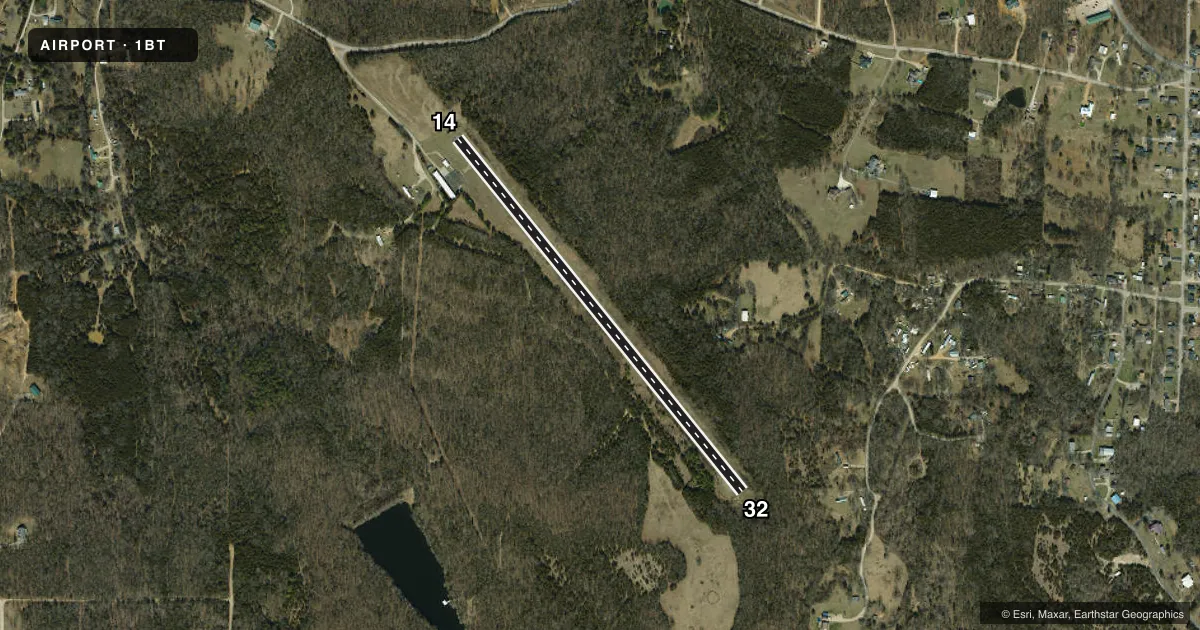
Runways & pattern
Full pagePattern entry · RWY 14
RIGHT TRAFFICRunway end performance
| End | TORA | TODA | ASDA | LDA | VGSI | Approach lights | Obstruction |
|---|---|---|---|---|---|---|---|
| 14 | — | — | — | — | — | — | 45', trees, 201' from thr, 125' R of cntrln, slope 0 |
| 32 | — | — | — | — | — | — | 35', trees, 245' from thr, 125' R of cntrln, slope 1 |
Declared distances in feet. TORA = takeoff run available, TODA = takeoff distance, ASDA = accelerate-stop, LDA = landing distance.
Airport sketch
Runways drawn to scale from FAA survey coordinates, rendered over satellite imagery. Not for navigation.
Approaches & charts
Services on the field
Fuel grades, oxygen, maintenance, ramp storage and lighting — as declared to the FAA by the airport operator.
Fuel & services
- Fuel
- Not available
Ramp & ground
- Transient storage
- Tie-down
- Hangar
- Lighting schedule
- SEE RMK
- Beacon schedule
- SS-SR
- Beacon
- White / Green (civil land)(WG)
- Wind indicator
- Lighted
Fuel & FBOs
Cheapest 100LL and Jet A on the field and nearby. Always confirm with the FBO before taxi.
Airport notes
Surface conditions, obstructions, local procedures, lighting outages and other notes published with each FAA cycle.
General notes
- NSTD RWY SAFETY AREA RWY 14/32 BOTH ENDS INSUFFICIENT LEN AND OBSTNS. LRG DROP OFF RWY 14 END.
- FOR CD CTC KANSAS CITY ARTCC AT 913-254-8508.
Lighting notes
- TO INCR INTST & ACTVT MIRL RWY 14/32 - CTAF
Approach & departure obstructions
- 3220 FT TREES, 125 FT L/R, 20 FT FROM RWY END.
Other notes
- HNGR STORAGE BASED ON AVBL.
VFR map & nearby airports
VFR sectional. Tap any ICAO chip to open that airport.
Key facts · 1BT
Answer card- ICAO
- 1BT
- Name
- BONNE TERRE MUNI
- Location
- BONNE TERRE, MISSOURI
- Elevation
- 910 ft MSL
- Traffic pattern altitude
- 1,910 ft MSL (1,000 AGL)
- Control tower
- Non-towered (use CTAF)
- Total runways
- 1
- Longest runway
- 14/32 · 2,800 ft
- Published ILS approaches
- 0
- Published frequencies
- 2
- Magnetic variation
- –
- Current flight rules
- VFR
- Current wind
- 000° at 0 kt
- Favored runway now
- –
Bonne Terre Muni sits in Bonne Terre, Missouri. Field elevation is 910 ft MSL. The airport has one runway. Runway 14/32 is 2,800 ft long and asphalt. There is no control tower. CTAF and UNICOM are both 122.975. No ILS approaches are published here.
Pattern altitude is not published. Use the standard 1,000 ft AGL pattern unless the current FAA Chart Supplement says otherwise. That puts the light piston pattern at about 1,910 ft MSL based on the field elevation, but verify before you fly. The published remarks matter here. Runway 14/32 has a nonstandard safety area with insufficient length and obstructions. There is also a large drop off at the runway 14 end. On runway 32, expect 20-foot trees about 125 feet left and right near the runway end. Medium intensity runway lights on 14/32 can be activated and brightened with the CTAF.
No on-field FBOs are listed. Contact the airport operator directly before arrival, or call the field on CTAF or UNICOM for current FBO availability. Hangar storage is based on availability. For clearance delivery, contact Kansas City ARTCC at 913-254-8508. If you are planning a night or low-weather arrival, check the current FAA Chart Supplement for any published restrictions and confirm the lighting setup before departure.