METAR & TAF KFAM
Current METAR
Observed 16:56Z
KFAM 271656Z AUTO 22008KT 10SM CLR 33/24 A2994 RMK AO2 SLP136 T03280244 $
- Wind
- 220° @ 8 kt
- Visibility
- 10 SM
- Temp / Dew
- 33°C / 24°C
- Altimeter
- 29.94 inHg
- Clouds
- CLR
- Density alt
- 3,308 ft
- Ceiling
- Unlimited
- Rules
- VFR
Airport info & contacts
Manager on record, flight service, ARTCC, attendance schedule and pattern altitude — published by the FAA and refreshed every 28 days.
Location
- From city
- 1 NM S
- VFR sectional
- ST LOUIS
- ARTCC
- ZKC · KANSAS CITY
- NOTAM facility
- FAM (NOTAM-D)
Airport manager
- Name
- BRIAN HINSON
- Phone
- 573-756-4502
- Address
- 110 W. COLUMBIA STREET, LONG MEMORIAL BUILDING, FARMINGTON MO 63640
Flight service · Hours
- FSS STL
- SAINT LOUIS1-800-WX-BRIEF
- Attendance
- 0730-1700
Frequencies
Tap any row to copy the frequency to your clipboard.
Runways & pattern
Full pagePattern entry · RWY 20
LEFT TRAFFICRunway end performance
| End | TORA | TODA | ASDA | LDA | VGSI | Approach lights | Obstruction |
|---|---|---|---|---|---|---|---|
| 02 | — | — | — | — | PAPI 4-box left(3°) | — | 39', trees, 1368' from thr, 150' R of cntrln, slope 29 |
| 20 | — | — | — | — | PAPI 4-box left(3°) | — | — |
Declared distances in feet. TORA = takeoff run available, TODA = takeoff distance, ASDA = accelerate-stop, LDA = landing distance.
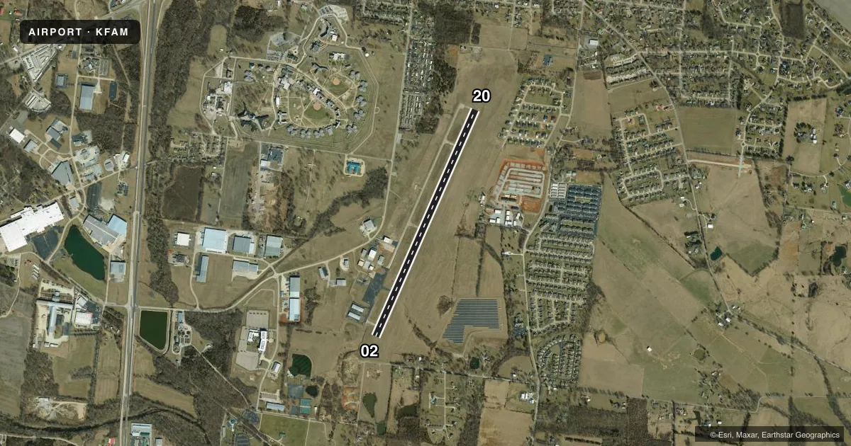
Airport sketch
Runways drawn to scale from FAA survey coordinates, rendered over satellite imagery. Not for navigation.
Approaches & charts
Services on the field
Fuel grades, oxygen, maintenance, ramp storage and lighting — as declared to the FAA by the airport operator.
Fuel & services
- Fuel
- 100LLA
- Oxygen (bottled)
- Not available
- Oxygen (bulk)
- Not available
- Airframe repair
- Major
- Power plant repair
- Major
- Other services
- AFRT,CHTR,SALES,SURV
Ramp & ground
- Transient storage
- Tie-down
- Landing fee
- No fee published
- Customs
- Not available
- Lighting schedule
- SEE RMK
- Beacon schedule
- SS-SR
- Beacon
- White / Green (civil land)(WG)
- Wind indicator
- Lighted
- Segmented circle
- Yes
Fuel & FBOs
Cheapest 100LL and Jet A on the field and nearby. Always confirm with the FBO before taxi.
Airport notes
Surface conditions, obstructions, local procedures, lighting outages and other notes published with each FAA cycle.
General notes
- HEL ACTIVITY ON & INVOF AIRFIELD.
- FOR CD IF UNA TO CTC ON FSS FREQ, CTC KANSAS CITY ARTCC AT 913-254-8508.
Lighting notes
- ACTVT REIL RWY 02 & 20; MIRL RWY 02/20 - CTAF. PAPI RWY 02 OPR CONSLY.
Runway surface & condition
- 02/20FOR RWY ONLY; CONTACT AMGR FOR TWY STRENGTH.
- 02/20100 FT X 75 FT FULL STRENGTH CONC SAFETY AREA SOUTHWEST END; 590 FT BY 60 FT ASPH SAFETY AREA NORTHEAST END, NOT FULL STRENGTH.
Approach & departure obstructions
- 02560 FT UNUSBL.
- 02RWY 02 APCH SLOPE 40:1 TO DSPLCD THR.
Other notes
- PROVIDED A CLEAR APCH TO EACH RY FOR A MINIM 20:1 GLIDE SLOPE AND A CLEAR TRANSITIONAL SFC FOR A 7:1 SLOPE.
- MANAGEREXT. 1601
VFR map & nearby airports
VFR sectional. Tap any ICAO chip to open that airport.
Key facts · KFAM
Answer card- ICAO
- KFAM
- Name
- FARMINGTON RGNL
- Location
- FARMINGTON, MISSOURI
- Elevation
- 945.7 ft MSL
- Traffic pattern altitude
- 1,945.7 ft MSL (1,000 AGL)
- Control tower
- Non-towered (use CTAF)
- Total runways
- 1
- Longest runway
- 02/20 · 4,323 ft
- Published ILS approaches
- 0
- Published frequencies
- 2
- Magnetic variation
- 2°
- Current flight rules
- VFR
- Current wind
- 220° at 8 kt
- Favored runway now
- RWY 20
Farmington Regional Airport is in Farmington, Missouri. The field elevation is 945.7 ft MSL. It has one runway. Runway 02/20 is 4,323 ft long with a concrete surface. The airport is non-towered. CTAF and UNICOM are both 122.8. No ILS approaches are published here.
Pattern altitude is not published. Use 1,000 ft AGL for light piston operations unless the current Chart Supplement or local procedures say otherwise. The on-field FBO is Farmington Regional Airport. It carries AVGAS 100LL and Jet A. Call (573) 756-4502 before arrival if you need current service details.
A few operational items matter here. Helicopter activity is on and near the field. Runway 02 has 560 ft unusable. The published remarks also note a displaced-threshold style approach slope on 02, so plan your descent carefully from that side. REIL and medium-intensity runway lights on 02 and 20 are activated by CTAF. PAPI on runway 02 operates continuously. The airport also notes clear approach and transitional surfaces, plus a manager contact for taxiway strength if you are concerned about runway-only gross weight. For any current noise, lighting, or field-use details, check the current Chart Supplement or call the airport operator directly.