METAR & TAF KUUV
Current METAR
Observed 10:55Z
KUUV 271055Z AUTO 21003KT 10SM CLR CLR A2996 RMK AO2
- Wind
- 210° @ 3 kt
- Visibility
- 10 SM
- Temp / Dew
- —
- Altimeter
- 29.96 inHg
- Clouds
- CLR
- Density alt
- —
- Ceiling
- Unlimited
- Rules
- VFR
Airport info & contacts
Manager on record, flight service, ARTCC, attendance schedule and pattern altitude — published by the FAA and refreshed every 28 days.
Location
- From city
- 1 NM N
- VFR sectional
- KANSAS CITY
- ARTCC
- ZKC · KANSAS CITY
- NOTAM facility
- STL (NOTAM-D)
Airport manager
- Name
- DEAN BLANKENSHIP
- Phone
- (573) 468-4912
- Address
- 345 N. CHURCH ST, SULLIVAN MO 63080
Flight service · Hours
- FSS STL
- SAINT LOUIS1-800-WX-BRIEF
- Attendance
- 0700-1600
Frequencies
Tap any row to copy the frequency to your clipboard.
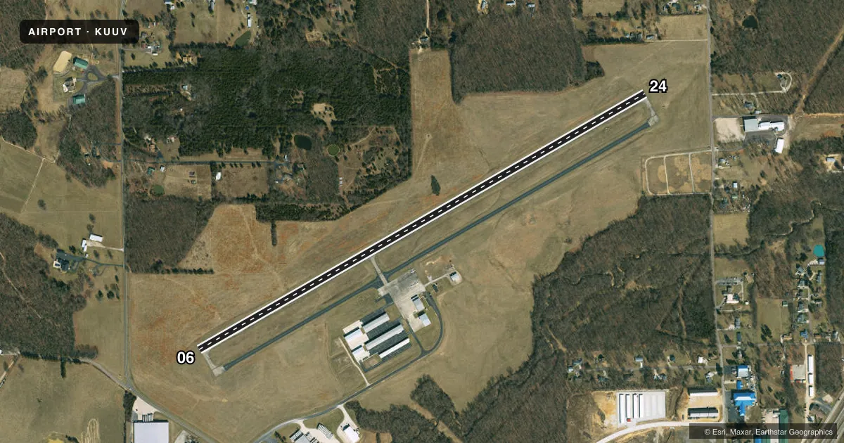
Runways & pattern
Full pagePattern entry · RWY 24
RIGHT TRAFFICRunway end performance
| End | TORA | TODA | ASDA | LDA | VGSI | Approach lights | Obstruction |
|---|---|---|---|---|---|---|---|
| 06 | — | — | — | — | PAPI 2-box left(4°) | — | 44', trees, 810' from thr, 110' R of cntrln, slope 13 |
| 24 | — | — | — | — | PAPI 2-box left(3°) | — | — |
Declared distances in feet. TORA = takeoff run available, TODA = takeoff distance, ASDA = accelerate-stop, LDA = landing distance.
Airport sketch
Runways drawn to scale from FAA survey coordinates, rendered over satellite imagery. Not for navigation.
Approaches & charts
Services on the field
Fuel grades, oxygen, maintenance, ramp storage and lighting — as declared to the FAA by the airport operator.
Fuel & services
- Fuel
- 100LLA
- Airframe repair
- Not available
- Power plant repair
- Not available
- Other services
- AMB,INSTR
Ramp & ground
- Transient storage
- Tie-down
- Lighting schedule
- SEE RMK
- Beacon schedule
- SS-SR
- Beacon
- White / Green (civil land)(WG)
- Wind indicator
- Lighted
- Segmented circle
- Yes
Fuel & FBOs
Cheapest 100LL and Jet A on the field and nearby. Always confirm with the FBO before taxi.
Airport notes
Surface conditions, obstructions, local procedures, lighting outages and other notes published with each FAA cycle.
General notes
- DEER, COYOTES, WATERFOWL ON & INVOF ARPT.
- FOR CD CTC KANSAS CITY ARTCC AT 913-254-8508.
Lighting notes
- DUSK-DAWN. MIRL RY 06/24 PRESET ON LOW INTST; TO INCR INTST ACTVT - CTAF. PAPI ON 24 HRS.
Runway surface & condition
- 06/24RESTRICTED TO ACFT 12,500 LBS MAX GWT OR LESS; PPR FOR ACFT EXCEEDING 12,500 LBS CALL AMGR.
Other notes
- PRVDD EXISTING SULLIVAN MEMORIAL ARPT IS CLSD UPON ACTIVATION OF SULLIVAN REGIONAL ARPT.
- 1AFT HRS CALL 573-468-8001 (POLICE DEPT.)
VFR map & nearby airports
VFR sectional. Tap any ICAO chip to open that airport.
Key facts · KUUV
Answer card- ICAO
- KUUV
- Name
- SULLIVAN RGNL
- Location
- SULLIVAN, MISSOURI
- Elevation
- 933 ft MSL
- Traffic pattern altitude
- 1,933 ft MSL (1,000 AGL)
- Control tower
- Non-towered (use CTAF)
- Total runways
- 1
- Longest runway
- 06/24 · 4,500 ft
- Published ILS approaches
- 0
- Published frequencies
- 2
- Magnetic variation
- 2°
- Current flight rules
- VFR
- Current wind
- 210° at 3 kt
- Favored runway now
- RWY 24
Sullivan Rgnl sits in Sullivan, Missouri. The field elevation is 933 ft MSL. It has one runway, 06/24, which is 4,500 ft long and concrete. There is no control tower. CTAF and UNICOM are both 122.7. No ILS approaches are published here.
Pattern altitude is not published. Use the standard 1,000 ft AGL pattern for light piston traffic unless the current Chart Supplement says otherwise. The on-field FBO is Sullivan Regional Airport. It carries AVGAS 100LL and JET A. Call (573) 468-4912 for current service details.
A few published remarks matter for planning. Runway 06/24 is limited to aircraft at 12,500 lb maximum gross weight or less unless you get prior permission from the airport manager. The runway lights are preset low from dusk to dawn. You can raise the intensity by keying the CTAF. The PAPI on runway 24 is on all the time. Deer, coyotes and waterfowl have been reported on and near the airport. If you need clearance delivery, contact Kansas City ARTCC. This is a non-towered field. Expect self-announce traffic. Keep a sharp lookout on final. Keep a sharp lookout in the pattern. Keep a sharp lookout on the runway.