METAR & TAF KVIH
Current METAR
Observed 16:53Z
KVIH 271653Z AUTO 21008KT 10SM CLR 33/24 A2994 RMK AO2 SLP123 T03280244
- Wind
- 210° @ 8 kt
- Visibility
- 10 SM
- Temp / Dew
- 33°C / 24°C
- Altimeter
- 29.94 inHg
- Clouds
- CLR
- Density alt
- 3,558 ft
- Ceiling
- Unlimited
- Rules
- VFR
Airport info & contacts
Manager on record, flight service, ARTCC, attendance schedule and pattern altitude — published by the FAA and refreshed every 28 days.
Location
- From city
- 11 NM N
- VFR sectional
- KANSAS CITY
- ARTCC
- ZKC · KANSAS CITY
- NOTAM facility
- VIH (NOTAM-D)
Airport manager
- Name
- CHRISTINA BORDERS
- Phone
- 573-299-4498
- Address
- 631 AIRPORT DRIVE, VICHY MO 65580
Flight service · Hours
- FSS COU
- COLUMBIA1-800-WX-BRIEF
- Attendance
- MON-FRI · 0600-1700
- SAT-SUN · 0800-1600
Frequencies
Tap any row to copy the frequency to your clipboard.
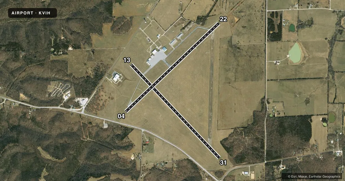
Runways & pattern
Full pagePattern entry · RWY 22
LEFT TRAFFIC| Runway | Heading (°M) | Length | Surface | Traffic |
|---|---|---|---|---|
| 13/31 | 135° / 315° | 5,501 ft | ASPH | Standard L |
| 04/22Favored | 45° / 225° | 5,500 ft | ASPH | Standard L |
Runway end performance
| End | TORA | TODA | ASDA | LDA | VGSI | Approach lights | Obstruction |
|---|---|---|---|---|---|---|---|
| 04 | — | — | — | — | PAPI 4-box left(3°) | — | 20', road, 435' from thr, 270' R of cntrln, slope 11 |
| 22 | — | — | — | — | VASI 4-box left(3°) | — | — |
Declared distances in feet. TORA = takeoff run available, TODA = takeoff distance, ASDA = accelerate-stop, LDA = landing distance.
Airport sketch
Runways drawn to scale from FAA survey coordinates, rendered over satellite imagery. Not for navigation.
Approaches & charts
Services on the field
Fuel grades, oxygen, maintenance, ramp storage and lighting — as declared to the FAA by the airport operator.
Fuel & services
- Fuel
- 100LLA
- Oxygen (bottled)
- Not available
- Oxygen (bulk)
- Not available
- Airframe repair
- Not available
- Power plant repair
- Not available
- Other services
- INSTR,PAJA
Ramp & ground
- Transient storage
- Tie-down
- Landing fee
- No fee published
- Customs
- Not available
- Lighting schedule
- SEE RMK
- Beacon schedule
- SS-SR
- Beacon
- White / Green (civil land)(WG)
- Wind indicator
- Lighted
- Segmented circle
- No
Fuel & FBOs
Cheapest 100LL and Jet A on the field and nearby. Always confirm with the FBO before taxi.
Airport notes
Surface conditions, obstructions, local procedures, lighting outages and other notes published with each FAA cycle.
General notes
- 144 FT WATER TOWER LCTD 2000 FT NNE OF RWY 13 THLD.
- RADIO CONTROLLED MODEL AIRPLANES INVOF ARPT.
- HELI PARKING ON SE CORNER OF APRON.
- WILDLIFE ON & INVOF ARPT.
- 270 FT ANTENNA TOWER 1.5 MILES SE OF RWY 31 THLD
- CLSD RWY UNUSBL AS TWY.
- FOR CD IF UNA TO CTC ON FSS FREQ, CTC KANSAS CITY ARTCC AT 913-254-8508.
Lighting notes
- ACTVT PAPI RWY 04; VASI RWY 22; MIRL RWY 04/22 AND RWY 13/31 - CTAF.
Approach & departure obstructions
- 04APCH RATIO TO DSPLCD THLD 29:1; DSPLCD THLD 1 FT LOWER THAN RY END.
VFR map & nearby airports
VFR sectional. Tap any ICAO chip to open that airport.
Key facts · KVIH
Answer card- ICAO
- KVIH
- Name
- ROLLA NTL
- Location
- ROLLA/VICHY, MISSOURI
- Elevation
- 1,147.8 ft MSL
- Traffic pattern altitude
- 2,147.8 ft MSL (1,000 AGL)
- Control tower
- Non-towered (use CTAF)
- Total runways
- 2
- Longest runway
- 13/31 · 5,501 ft
- Published ILS approaches
- 0
- Published frequencies
- 2
- Magnetic variation
- 2°
- Current flight rules
- VFR
- Current wind
- 210° at 8 kt
- Favored runway now
- RWY 22
Rolla National Airport sits in Rolla and Vichy, Missouri. Field elevation is 1,147.8 ft MSL. The airport has two asphalt runways. The longest is 5,501 ft on runway 13/31. There is no control tower. CTAF and UNICOM are both 123.0. No ILS approaches are published.
Pattern altitude is not published. Use standard 1,000 ft AGL for light piston traffic unless the current Chart Supplement says otherwise. That puts the pattern about 2,148 ft MSL. The on-field FBO is Rolla National Airport. It carries 100LL and Jet A. Call ahead at (573) 299-4498 for current services.
A few published remarks matter here. A 144-foot water tower sits north-northeast of runway 13. A 270-foot antenna tower is southeast of runway 31. Wildlife has been reported on and near the airport. Radio-controlled model airplanes are also in the vicinity. Runway 04 has a displaced threshold note. The field also says the closed runway is unusable as a taxiway. For a first visit, plan for an uncontrolled airport with light local traffic, then verify the current Chart Supplement for any changes before departure.