METAR & TAF K07
K07 does not publish a METAR.
Showing the nearest reporting station: KVIH (ROLLA NTL) · 11.7 NM away. Conditions at K07 may differ.
METAR · KVIH
Observed 16:53Z
KVIH 271653Z AUTO 21008KT 10SM CLR 33/24 A2994 RMK AO2 SLP123 T03280244
- Wind
- 210° @ 8 kt
- Visibility
- 10 SM
- Temp / Dew
- 33°C / 24°C
- Altimeter
- 29.94 inHg
- Clouds
- CLR
- Density alt
- 3,359 ft
- Ceiling
- Unlimited
- Rules
- VFR
Airport info & contacts
Manager on record, flight service, ARTCC, attendance schedule and pattern altitude — published by the FAA and refreshed every 28 days.
Location
- From city
- 3 NM SW
- VFR sectional
- KANSAS CITY
- ARTCC
- ZKC · KANSAS CITY
- NOTAM facility
- COU (NOTAM-D)
Airport manager
- Name
- MAXINE DICKMAN FOSMARK
- Phone
- 573-430-3065
- Address
- P.O. BOX 925, ROLLA MO 65402
Flight service · Hours
- FSS COU
- COLUMBIA1-800-WX-BRIEF
- Attendance
- Unattended
Frequencies
Tap any row to copy the frequency to your clipboard.
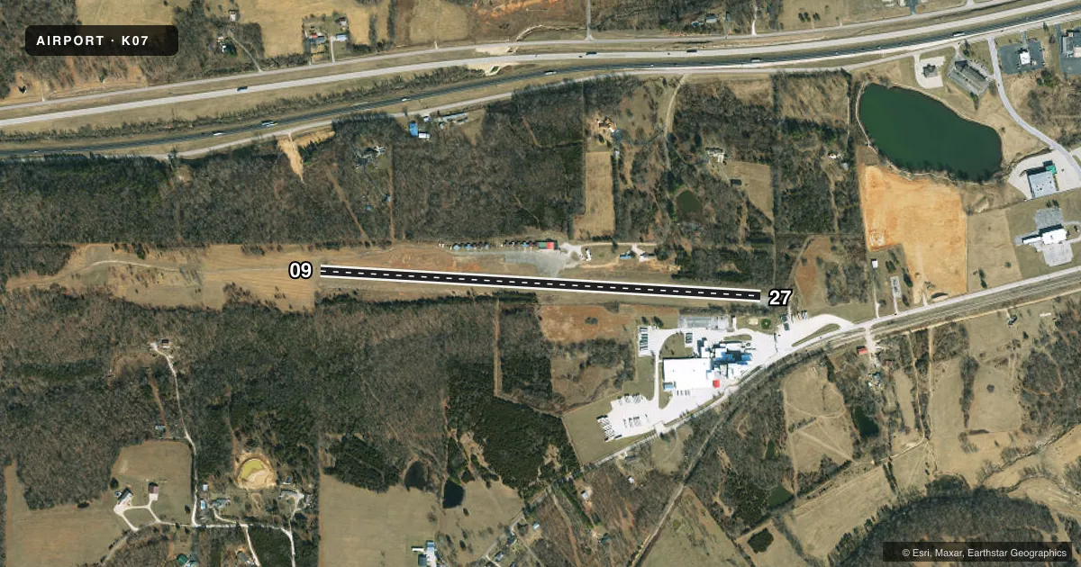
Runways & pattern
Full pagePattern entry · RWY 27
LEFT TRAFFICRunway end performance
| End | TORA | TODA | ASDA | LDA | VGSI | Approach lights | Obstruction |
|---|---|---|---|---|---|---|---|
| 09 | — | — | — | — | — | — | 28', trees, 600' from thr, 117' R of cntrln, slope 14 |
| 27 | — | — | — | — | — | — | 55', trees, 200' from thr, 125' R of cntrln, slope 0 |
Declared distances in feet. TORA = takeoff run available, TODA = takeoff distance, ASDA = accelerate-stop, LDA = landing distance.
Airport sketch
Runways drawn to scale from FAA survey coordinates, rendered over satellite imagery. Not for navigation.
Approaches & charts
Services on the field
Fuel grades, oxygen, maintenance, ramp storage and lighting — as declared to the FAA by the airport operator.
Fuel & services
- Fuel
- Not available
- Oxygen (bottled)
- Not available
- Oxygen (bulk)
- Not available
Ramp & ground
- Transient storage
- Tie-down
- Landing fee
- No fee published
- Customs
- Not available
- Wind indicator
- Yes
- Segmented circle
- No
Fuel & FBOs
Cheapest 100LL and Jet A on the field and nearby. Always confirm with the FBO before taxi.
Airport notes
Surface conditions, obstructions, local procedures, lighting outages and other notes published with each FAA cycle.
General notes
- WILDLIFE ON & INVOF ARPT.
- RY 09/27 LINE OF SIGHT OBSTRUCTED BY GRADE CHANGE IN RY.
- TALL BRUSH LOCATED 70-125 FT SOUTH OF RY, FM RY 09 THLD TO ACCESS TWY.
- FOR CD CTC KANSAS CITY ARTCC AT 913-254-8508.
Approach & departure obstructions
- 09RWY 09 20-25 FT TREES, BRUSH 0-30 FT FM RWY END, 70 FT RIGHT.
- 27RWY 27 1-55 FT TREES; FENCES; POWERLINES; BRUSHES & HIGH GND 0-200 FT FM RWY END LEFT & RIGHT.
- 09MARKINGS FADED.
- 27MARKINGS FADED.
- 09RWY 09 NSTD BSC MARKINGS: INCORRECT SPACING OF DESIGNATION MARKINGS RY 09.
- 27NSTD BSC MARKNGS; INCORRECT LENGTH; WIDTH; COLOR & SPACING OF DSPLCD THLD & DESIGNATION MARKINGS RY 27.
- 27RY 27 9:1TO DSPLCD THLD; +30 FT TREE, 340 FT FM DSPLCD THLD, 50 FT R.
Other notes
- THIS AIRPORT HAS BEEN SURVEYED BY THE NATIONAL GEODETIC SURVEY.
- UNICOM UNMON.
- 09/27RWY 9/27 PAVEMENT CRACKING, VEGETATION GROWING IN CRACKS.
VFR map & nearby airports
VFR sectional. Tap any ICAO chip to open that airport.
Key facts · K07
Answer card- ICAO
- K07
- Name
- ROLLA DOWNTOWN
- Location
- ROLLA, MISSOURI
- Elevation
- 987 ft MSL
- Traffic pattern altitude
- 1,987 ft MSL (1,000 AGL)
- Control tower
- Non-towered (use CTAF)
- Total runways
- 1
- Longest runway
- 09/27 · 3,028 ft
- Published ILS approaches
- 0
- Published frequencies
- 2
- Magnetic variation
- 5°
- Current flight rules
- VFR
- Current wind
- 210° at 8 kt
- Favored runway now
- RWY 27
Rolla Downtown is in Rolla, Missouri. The field elevation is 987 ft MSL. It has one runway, 09/27, which is 3,028 ft long and paved with asphalt. There is no control tower. CTAF and UNICOM are both 122.8. The UNICOM is unmonitored. No ILS approaches are published here.
The pattern altitude is not published. Use the standard 1,000 ft AGL for light piston operations unless the current FAA Chart Supplement says otherwise. On the published remarks, runway 27 has several issues that matter on short final. There are trees, fences, powerlines, brush and high ground near the departure end. Markings are nonstandard and faded. Runway 09 also has trees and brush close to the end. The runway pavement has cracking with vegetation in the cracks. Wildlife is present on and near the airport.
There are no on-field FBOs listed in the facts. Call the airport operator or the field directly before arrival to confirm services. For clearance delivery, contact Kansas City ARTCC at 913-254-8508. First-time pilots should brief the runway slope and the obstructed line of sight caused by the grade change. Check the current FAA Chart Supplement before flying in for any updated operational notes.