METAR & TAF MO1
MO1 does not publish a METAR.
Showing the nearest reporting station: KOZS (CAMDENTON MEML-LAKE RGNL) · 14.6 NM away. Conditions at MO1 may differ.
METAR · KOZS
Observed 19:15Z
KOZS 271915Z AUTO 23008G16KT 10SM CLR 36/18 A2986 RMK AO2
- Wind
- 230° @ 8G16 kt
- Visibility
- 10 SM
- Temp / Dew
- 36°C / 18°C
- Altimeter
- 29.86 inHg
- Clouds
- CLR
- Density alt
- 3,971 ft
- Ceiling
- Unlimited
- Rules
- VFR
Airport info & contacts
Manager on record, flight service, ARTCC, attendance schedule and pattern altitude — published by the FAA and refreshed every 28 days.
Location
- From city
- 1 NM N
- VFR sectional
- KANSAS CITY
- ARTCC
- ZKC · KANSAS CITY
- NOTAM facility
- COU (NOTAM-D)
Airport manager
- Name
- DANA TANNER
- Phone
- 573-765-3532
- Address
- PO BOX 798, RICHLAND MO 65556
Flight service · Hours
- FSS COU
- COLUMBIA1-800-WX-BRIEF
- Attendance
- Unattended
Frequencies
Tap any row to copy the frequency to your clipboard.
Runways & pattern
Full pagePattern entry · RWY 32
LEFT TRAFFICRunway end performance
| End | TORA | TODA | ASDA | LDA | VGSI | Approach lights | Obstruction |
|---|---|---|---|---|---|---|---|
| 14 | — | — | — | — | — | — | 40', trees, 418' from thr, 150' R of cntrln, slope 5 |
| 32 | — | — | — | — | — | — | 32', trees, 202' from thr, 125' R of cntrln, slope 0 |
Declared distances in feet. TORA = takeoff run available, TODA = takeoff distance, ASDA = accelerate-stop, LDA = landing distance.
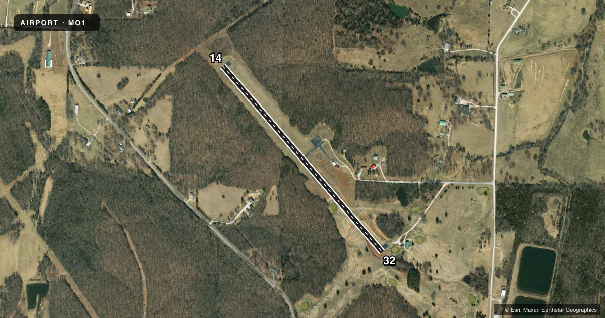
Airport sketch
Runways drawn to scale from FAA survey coordinates, rendered over satellite imagery. Not for navigation.
Approaches & charts
Services on the field
Fuel grades, oxygen, maintenance, ramp storage and lighting — as declared to the FAA by the airport operator.
Fuel & services
- Fuel
- Not available
- Oxygen (bottled)
- Not available
- Oxygen (bulk)
- Not available
Ramp & ground
- Transient storage
- Not published
- Landing fee
- No fee published
- Lighting schedule
- SEE RMK
- Wind indicator
- Lighted
- Segmented circle
- Yes
Fuel & FBOs
Cheapest 100LL and Jet A on the field and nearby. Always confirm with the FBO before taxi.
Airport notes
Surface conditions, obstructions, local procedures, lighting outages and other notes published with each FAA cycle.
General notes
- GOLFERS CROSSING RY APPROXIMATELY 800 FT NORTHWEST OF RY 32 THR.
- WILDLIFE ON & INVOF ARPT.
- FOR CD CTC KANSAS CITY ARTCC AT 913-254-8508.
Lighting notes
- DUSK-DAWN. ACTVT LIRL RY 14/32 - CTAF.
- ULTRALIGHT ACTIVITY ON AND INVOF ARPT.
Approach & departure obstructions
- 32RWY 32 +1-6 FT GND; TREE, 35 FT, 55 FT FM RWY END 70 FT R; TREES 18-35 FT, 180-200 FT FM RWY END, L & R.
- 14RWY 14 +40 FT TREES, 588 FT, 150FT L-R, 14:1 BASED ON DSPLCD THLD.
- 32RWY 32 APCH SLOPE 9:1, +32 FT TREES, 302 FT FM DSPLCD THLD, 50 FT L/R,
Other notes
- MANAGERMAYOR
VFR map & nearby airports
VFR sectional. Tap any ICAO chip to open that airport.
Key facts · MO1
Answer card- ICAO
- MO1
- Name
- RICHLAND MUNI
- Location
- RICHLAND, MISSOURI
- Elevation
- 1,110 ft MSL
- Traffic pattern altitude
- 2,110 ft MSL (1,000 AGL)
- Control tower
- Non-towered (use CTAF)
- Total runways
- 1
- Longest runway
- 14/32 · 3,000 ft
- Published ILS approaches
- 0
- Published frequencies
- 1
- Magnetic variation
- 4°
- Current flight rules
- VFR
- Current wind
- 230° at 8 kt
- Favored runway now
- RWY 32
Richland Muni sits in Richland, Missouri at 1,110 ft MSL. It has one runway. Runway 14/32 is 3,000 ft long and asphalt. There is no control tower. CTAF is 122.9. No ILS approaches are published here. The pattern altitude is not published, so use the standard 1,000 ft AGL for light piston traffic unless the current Chart Supplement says otherwise. That puts the traffic pattern at 2,110 ft MSL based on the field elevation.
This is a small non-towered field, so keep your scan tight and make your calls early. Published remarks matter here. Golfers cross the runway area near the 32 end. There are tree and terrain-related obstructions on both ends, with the more detailed notes calling out trees near the displaced thresholds and near the runway end on 32. Lighting is active from dusk to dawn. Low intensity runway lights on 14/32 are activated by the CTAF. Wildlife is also present on and near the airport. Ultralight activity is reported in and around the field.
There are no on-field FBOs listed in the provided facts. Check with the airport operator or the FBO directly by phone before arrival if you need fuel or ramp details. The airport manager is the mayor.