METAR & TAF KLBO
Current METAR
Observed 13:35Z
KLBO 271335Z AUTO 23007KT 10SM CLR 28/22 A2999 RMK AO2
- Wind
- 230° @ 7 kt
- Visibility
- 10 SM
- Temp / Dew
- 28°C / 22°C
- Altimeter
- 29.99 inHg
- Clouds
- CLR
- Density alt
- 3,111 ft
- Ceiling
- Unlimited
- Rules
- VFR
Airport info & contacts
Manager on record, flight service, ARTCC, attendance schedule and pattern altitude — published by the FAA and refreshed every 28 days.
Location
- From city
- 3 NM S
- VFR sectional
- KANSAS CITY
- ARTCC
- ZKC · KANSAS CITY
- NOTAM facility
- COU (NOTAM-D)
Airport manager
- Name
- MIKE WOOD
- Phone
- (417) 532-7879
- Address
- PO BOX 111, LEBANON MO 65536
Flight service · Hours
- FSS COU
- COLUMBIA1-800-WX-BRIEF
- Attendance
- 0700-1800
Frequencies
Tap any row to copy the frequency to your clipboard.
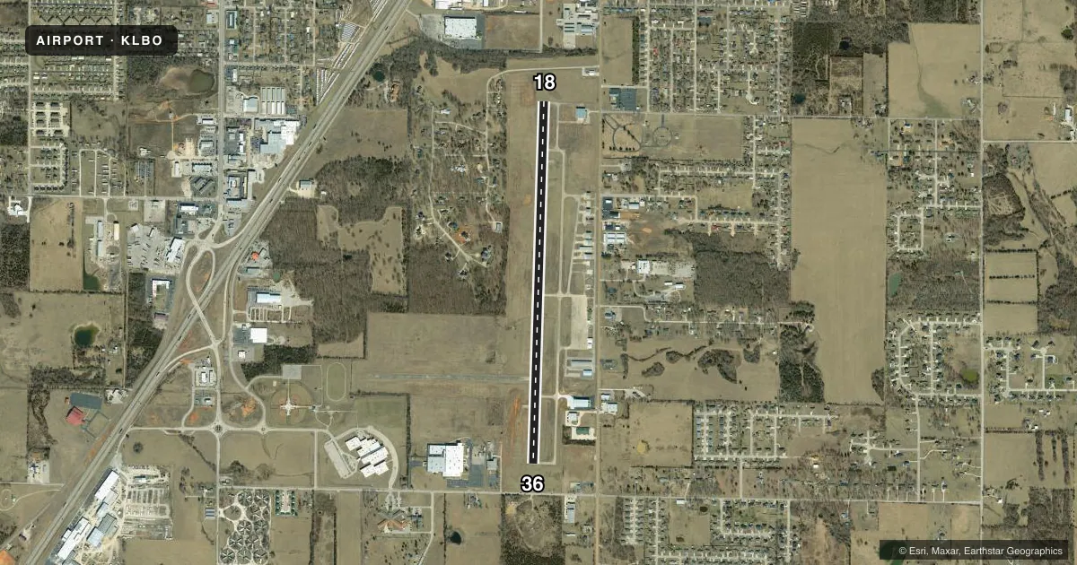
Runways & pattern
Full pagePattern entry · RWY 18
LEFT TRAFFICRunway end performance
| End | TORA | TODA | ASDA | LDA | VGSI | Approach lights | Obstruction |
|---|---|---|---|---|---|---|---|
| 18 | — | — | — | — | PAPI 4-box left(3°) | — | 26', trees, 600' from thr, 300' R of cntrln, slope 15 |
| 36 | — | — | — | — | PAPI 4-box left(3°) | — | — |
Declared distances in feet. TORA = takeoff run available, TODA = takeoff distance, ASDA = accelerate-stop, LDA = landing distance.
Airport sketch
Runways drawn to scale from FAA survey coordinates, rendered over satellite imagery. Not for navigation.
Approaches & charts
Services on the field
Fuel grades, oxygen, maintenance, ramp storage and lighting — as declared to the FAA by the airport operator.
Fuel & services
- Fuel
- 100LLA1+
- Oxygen (bottled)
- Not available
- Oxygen (bulk)
- Not available
- Airframe repair
- Minor
- Power plant repair
- Minor
- Other services
- AGRI,CHTR,INSTR,RNTL,SALES
Ramp & ground
- Transient storage
- Tie-down
- Hangar
- Landing fee
- No fee published
- Customs
- Not available
- Lighting schedule
- SEE RMK
- Beacon schedule
- SS-SR
- Beacon
- White / Green (civil land)(WG)
- Wind indicator
- Lighted
Fuel & FBOs
Cheapest 100LL and Jet A on the field and nearby. Always confirm with the FBO before taxi.
Airport notes
Surface conditions, obstructions, local procedures, lighting outages and other notes published with each FAA cycle.
General notes
- SPRAYER ACFT ON AND INVOF ARPT DURING SPRING AND SUMMER MONTHS.
- BIRDS, WILDLIFE ON & INVOF ARPT.
- FOR CD CTC SPRINGFIELD APCH AT 417-868-5620/5619.
Lighting notes
- ACTVT REIL RWY 18 & 36; PAPI RWY 36; MIRL RWY 18/36 - CTAF.
VFR map & nearby airports
VFR sectional. Tap any ICAO chip to open that airport.
Key facts · KLBO
Answer card- ICAO
- KLBO
- Name
- FLOYD W JONES LEBANON
- Location
- LEBANON, MISSOURI
- Elevation
- 1,320.7 ft MSL
- Traffic pattern altitude
- 2,320.7 ft MSL (1,000 AGL)
- Control tower
- Non-towered (use CTAF)
- Total runways
- 1
- Longest runway
- 18/36 · 5,000 ft
- Published ILS approaches
- 0
- Published frequencies
- 5
- Magnetic variation
- 3°
- Current flight rules
- VFR
- Current wind
- 230° at 7 kt
- Favored runway now
- RWY 18
Floyd W Jones Lebanon is in Lebanon, Missouri. The field elevation is 1,320.7 ft MSL. It has one runway. Runway 18/36 is 5,000 ft long with an asphalt surface. There is no control tower. Use CTAF 122.8 for the common traffic advisory frequency. Pattern altitude is not published, so plan on the standard 1,000 ft AGL for light piston traffic unless the current Chart Supplement says otherwise.
No ILS approaches are published here. The airport has runway end identifier lights on 18 and 36. Medium intensity runway lights are also installed on both ends. Runway 36 has a PAPI. The on-field FBO is Lebanon Airport. It carries 100LL and Jet A. For clearance delivery, Springfield Approach handles it. The published remarks also call out sprayer aircraft in the area during spring and summer. Birds and wildlife are also a factor. That matters on departure and in the pattern.
This is a non-towered field at moderate elevation. Expect normal Midwest VFR planning, with extra attention to traffic calls and runway lighting at night. If you need current procedures or any restriction details, check the current FAA Chart Supplement or call the airport operator before you go.