METAR & TAF H58
H58 does not publish a METAR.
Showing the nearest reporting station: KLBO (FLOYD W JONES LEBANON) · 28.2 NM away. Conditions at H58 may differ.
METAR · KLBO
Observed 20:15Z
KLBO 272015Z AUTO 21011G16KT 10SM CLR 36/21 A2989 RMK AO2
- Wind
- 210° @ 11G16 kt
- Visibility
- 10 SM
- Temp / Dew
- 36°C / 21°C
- Altimeter
- 29.89 inHg
- Clouds
- CLR
- Density alt
- 4,533 ft
- Ceiling
- Unlimited
- Rules
- VFR
Airport info & contacts
Manager on record, flight service, ARTCC, attendance schedule and pattern altitude — published by the FAA and refreshed every 28 days.
Location
- From city
- 3 NM NE
- VFR sectional
- KANSAS CITY
- ARTCC
- ZKC · KANSAS CITY
- NOTAM facility
- COU (NOTAM-D)
Airport manager
- Name
- KEVIN WRIGHT
- Phone
- 417-848-0075
- Address
- 442 HWY V, SEYMOUR MO 65746
Flight service · Hours
- FSS COU
- COLUMBIA1-800-WX-BRIEF
- Attendance
- Unattended
Frequencies
Tap any row to copy the frequency to your clipboard.
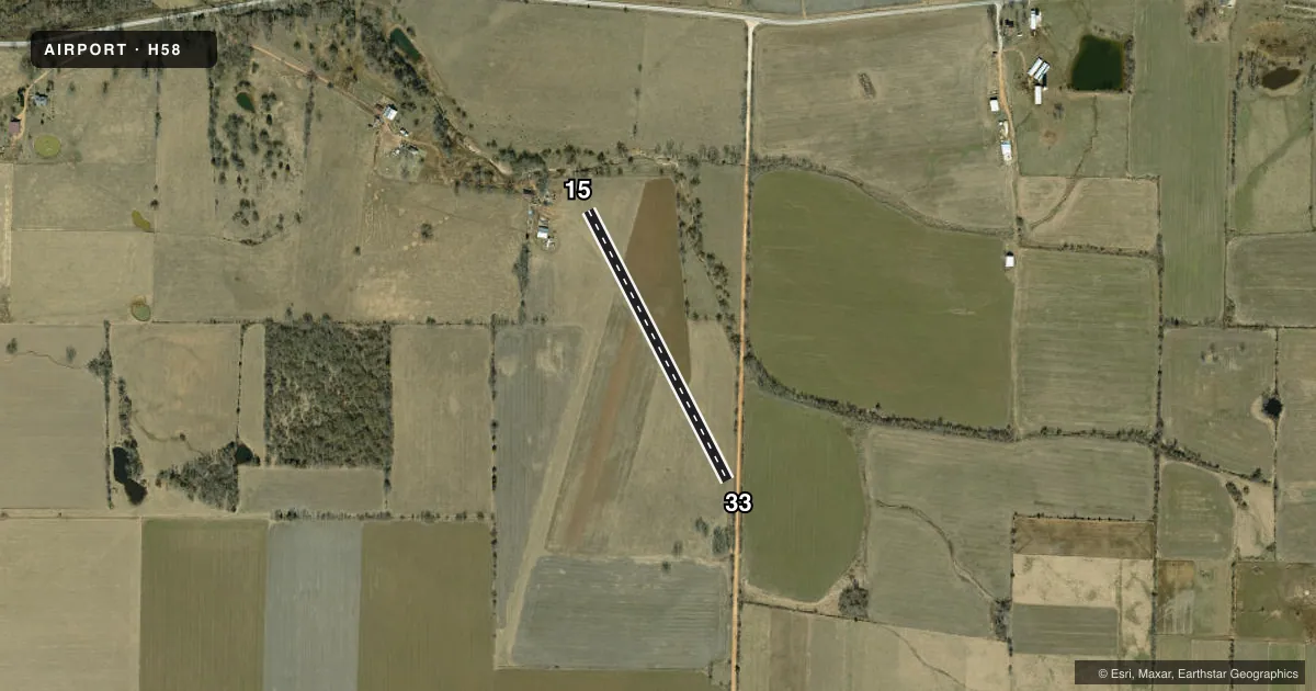
Runways & pattern
Full pagePattern entry · RWY 15
LEFT TRAFFICRunway end performance
| End | TORA | TODA | ASDA | LDA | VGSI | Approach lights | Obstruction |
|---|---|---|---|---|---|---|---|
| 15 | — | — | — | — | — | — | 62', trees, 290' from thr, 30' R of cntrln, slope 4 |
| 33 | — | — | — | — | — | — | 32', trees, 200' from thr, 50' R of cntrln, slope 6 |
Declared distances in feet. TORA = takeoff run available, TODA = takeoff distance, ASDA = accelerate-stop, LDA = landing distance.
Airport sketch
Runways drawn to scale from FAA survey coordinates, rendered over satellite imagery. Not for navigation.
Approaches & charts
Services on the field
Fuel grades, oxygen, maintenance, ramp storage and lighting — as declared to the FAA by the airport operator.
Fuel & services
- Fuel
- Not available
- Other services
- RNTL
Ramp & ground
- Transient storage
- Tie-down
- Landing fee
- No fee published
- Wind indicator
- Yes
- Segmented circle
- No
Fuel & FBOs
Cheapest 100LL and Jet A on the field and nearby. Always confirm with the FBO before taxi.
Airport notes
Surface conditions, obstructions, local procedures, lighting outages and other notes published with each FAA cycle.
General notes
- WILDLIFE ON & INVOF ARPT.
- AFT HVY RAINS CALL 417-848-0075 FOR RY CONDS.
- LN OF SIGHT FM RY ENDS OBSTD BY CHGS IN RY GRADE.
- NTSD RY SAFETY AREAS BYD EACH RY END; INCORRECT TERRAIN GRADS, FENCES, CONCRETE FENCE POSTS, TREES, BRUSH, DITCHES, & BLDGS.
- FOR CD CTC SPRINGFIELD APCH AT 417-868-5620/5619.
Other notes
- CONSTRUCTED PRIOR TO 5/15/59.
- PN FROM ARPT OWNER
- MANAGERALTN PHONE NBR 417-848-0075
- 01/19FIRST 1000 FT OF RY 19 HAS A VERY STEEP SLP WITH OBSTNS AT RY END.
- 15/33RY SFC ROUGH; ROLLING, UNEVEN & NARROW WITH TALL OBSTNS AT RY END.
VFR map & nearby airports
VFR sectional. Tap any ICAO chip to open that airport.
Key facts · H58
Answer card- ICAO
- H58
- Name
- OWEN FLD
- Location
- SEYMOUR, MISSOURI
- Elevation
- 1,593 ft MSL
- Traffic pattern altitude
- 2,593 ft MSL (1,000 AGL)
- Control tower
- Non-towered (use CTAF)
- Total runways
- 1
- Longest runway
- 15/33 · 1,725 ft
- Published ILS approaches
- 0
- Published frequencies
- 1
- Magnetic variation
- 4°
- Current flight rules
- VFR
- Current wind
- 210° at 11 kt
- Favored runway now
- RWY 15
OWEN FLD sits in Seymour, Missouri. Field elevation is 1,593 ft MSL. The airport has one runway. Runway 15/33 is 1,725 ft long and turf. No control tower is published, so plan to self-announce on CTAF 122.9. Work the traffic pattern with extra attention. Pattern altitude is not published. Use 1,000 ft AGL unless the current FAA Chart Supplement says otherwise.
No ILS approaches are published here. The field is small and the runway environment deserves a close look before you commit. Published remarks call out rough, uneven turf. They also note tall obstructions at the runway end. Runway safety areas are not standard. The runway ends have obstructed sight lines because of grade changes. Wildlife is also reported on and near the airport.
If you need clearance delivery, Springfield Approach is the published contact. There are no on-field FBOs listed. Verify services with the airport operator or call the field directly before you go. For a first visit, treat this as a short turf strip with limited margin for error. Walk through the runway condition, slope and obstacle picture before arrival. After heavy rain, call for runway conditions before launching.