METAR & TAF KAOV
KAOV does not publish a METAR.
Showing the nearest reporting station: KBBG (BRANSON) · 36.3 NM away. Conditions at KAOV may differ.
METAR · KBBG
Observed 19:45Z
KBBG 271945Z 18008KT 10SM CLR 35/20 A2991
- Wind
- 180° @ 8 kt
- Visibility
- 10 SM
- Temp / Dew
- 35°C / 20°C
- Altimeter
- 29.91 inHg
- Clouds
- CLR
- Density alt
- 4,038 ft
- Ceiling
- Unlimited
- Rules
- VFR
Airport info & contacts
Manager on record, flight service, ARTCC, attendance schedule and pattern altitude — published by the FAA and refreshed every 28 days.
Location
- From city
- 2 NM NW
- VFR sectional
- KANSAS CITY
- ARTCC
- ZKC · KANSAS CITY
- NOTAM facility
- COU (NOTAM-D)
Airport manager
- Name
- DAVID DAVIDSON
- Phone
- 417-840-2301
- Address
- PO BOX 967, AVA MO 65608
Flight service · Hours
- FSS COU
- COLUMBIA1-800-WX-BRIEF
- Attendance
- Unattended
Frequencies
Tap any row to copy the frequency to your clipboard.
Runways & pattern
Full pagePattern entry · RWY 13
LEFT TRAFFICRunway end performance
| End | TORA | TODA | ASDA | LDA | VGSI | Approach lights | Obstruction |
|---|---|---|---|---|---|---|---|
| 13 | — | — | — | — | PAPI 2-box left(3°) | — | 37', trees, 235' from thr, 197' R of cntrln, slope 1 |
Declared distances in feet. TORA = takeoff run available, TODA = takeoff distance, ASDA = accelerate-stop, LDA = landing distance.
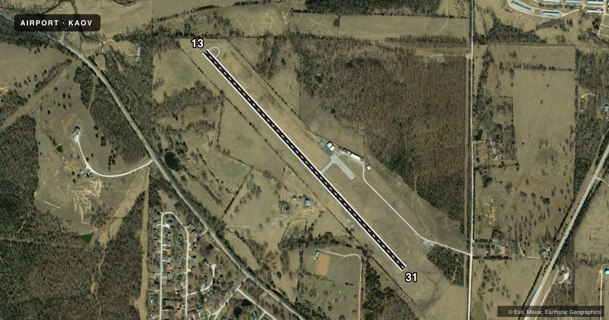
Airport sketch
Runways drawn to scale from FAA survey coordinates, rendered over satellite imagery. Not for navigation.
Approaches & charts
Services on the field
Fuel grades, oxygen, maintenance, ramp storage and lighting — as declared to the FAA by the airport operator.
Fuel & services
- Fuel
- 100LL
- Oxygen (bottled)
- Not available
- Oxygen (bulk)
- Not available
- Airframe repair
- Major
- Power plant repair
- Major
- Other services
- INSTR,RNTL
Ramp & ground
- Transient storage
- Tie-down
- Landing fee
- No fee published
- Customs
- Not available
- Lighting schedule
- SEE RMK
- Beacon schedule
- SS-SR
- Beacon
- White / Green (civil land)(WG)
- Wind indicator
- Lighted
Fuel & FBOs
Cheapest 100LL and Jet A on the field and nearby. Always confirm with the FBO before taxi.
Airport notes
Surface conditions, obstructions, local procedures, lighting outages and other notes published with each FAA cycle.
General notes
- NTSD RY SAFETY AREA BYD RY 13 END, INSUF LENGTH AND LARGE DROP OFF.
- 100LL SELF SVC CREDIT CARD AVBL 24 HRS.
- CLICK PCL 5 TIMES TO UNLOCK TERMINAL DOOR.
- FOR CD CTC SPRINGFIELD APCH AT 417-868-5620/5619.
Lighting notes
- ACTVT PAPI RWY 13; MIRL RWY 13/31 - CTAF. PAPI INTST OPER ON PHOTO CELL DAY/NGT; MIRL INTST VRBL: 3, 5, 7 CLICKS - CTAF.
Approach & departure obstructions
- 13TREES 10-35FT 10-175FT FROM RWY END, 150-250 FT RIGHT; TREES 10-43 FT 25-70 FT FROM RWY END, 235 FT LEFT
Other notes
- THIS AIRPORT HAS BEEN SURVEYED BY THE NATIONAL GEODETIC SURVEY.
VFR map & nearby airports
VFR sectional. Tap any ICAO chip to open that airport.
Key facts · KAOV
Answer card- ICAO
- KAOV
- Name
- AVA BILL MARTIN MEML
- Location
- AVA, MISSOURI
- Elevation
- 1,311 ft MSL
- Traffic pattern altitude
- 2,311 ft MSL (1,000 AGL)
- Control tower
- Non-towered (use CTAF)
- Total runways
- 1
- Longest runway
- 13/31 · 3,634 ft
- Published ILS approaches
- 0
- Published frequencies
- 3
- Magnetic variation
- 2°
- Current flight rules
- VFR
- Current wind
- 180° at 8 kt
- Favored runway now
- RWY 13
AVA Bill Martin Memorial Airport sits in Ava, Missouri. Field elevation is 1,311 ft MSL. The airport has one runway. Runway 13/31 is 3,634 ft long with an asphalt surface. There is no control tower. CTAF and UNICOM are both 122.7. Springfield Approach is on 126.35 for approach and departure work.
No ILS approaches are published here. Pattern altitude is not published. Use the standard 1,000 ft AGL pattern unless local procedures or the current Chart Supplement say otherwise. That puts the light piston pattern at 2,311 ft MSL based on the field elevation.
On the field, 100LL self-serve is available 24 hours with credit card payment. The airport lighting is pilot controlled. Runway 13 has a PAPI. Runway 13 and 31 have medium intensity runway lights. The lights use CTAF clicks for activation. The terminal door is also tied to the pilot controlled lighting system. Five clicks unlock it.
First-time pilots should pay close attention to the runway 13 end. Trees sit near that end, both close in and off to the sides. There is also a nonstandard runway safety area beyond runway 13 with a large drop off. That makes runway 13 the side to brief carefully before arrival or departure. The airport has been surveyed by the National Geodetic Survey.