METAR & TAF 1H5
1H5 does not publish a METAR.
Showing the nearest reporting station: KUNO (WEST PLAINS RGNL) · 7.1 NM away. Conditions at 1H5 may differ.
METAR · KUNO
Observed 19:53Z
KUNO 271953Z AUTO 24007KT 10SM 34/23 A2989 RMK AO2 SLP105 T03390233
- Wind
- 240° @ 7 kt
- Visibility
- 10 SM
- Temp / Dew
- 34°C / 23°C
- Altimeter
- 29.89 inHg
- Clouds
- Clear
- Density alt
- 3,863 ft
- Ceiling
- Unlimited
- Rules
- VFR
Airport info & contacts
Manager on record, flight service, ARTCC, attendance schedule and pattern altitude — published by the FAA and refreshed every 28 days.
Location
- From city
- 1 NM E
- VFR sectional
- KANSAS CITY
- Pattern altitude
- 800 ft AGL · 2,047 ft MSL
- ARTCC
- ZKC · KANSAS CITY
- NOTAM facility
- COU (NOTAM-D)
Airport manager
- Name
- BERLIN BATESEL
- Phone
- 417-469-2107
- Address
- 3311 COUNTY ROAD 3900, WILLOW SPRINGS MO 65793
Flight service · Hours
- FSS COU
- COLUMBIA1-800-WX-BRIEF
- Attendance
- Unattended
Frequencies
Tap any row to copy the frequency to your clipboard.
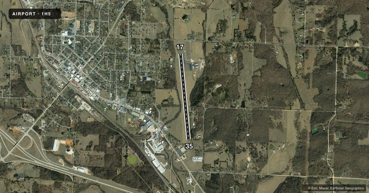
Runways & pattern
Full pagePattern entry · RWY 17
LEFT TRAFFICRunway end performance
| End | TORA | TODA | ASDA | LDA | VGSI | Approach lights | Obstruction |
|---|---|---|---|---|---|---|---|
| 17 | — | — | — | — | — | — | 52', trees, 1032' from thr, 175' R of cntrln, slope 16 |
| 35 | — | — | — | — | — | — | 36', trees, 415' from thr, 105' R of cntrln, slope 5 |
Declared distances in feet. TORA = takeoff run available, TODA = takeoff distance, ASDA = accelerate-stop, LDA = landing distance.
Airport sketch
Runways drawn to scale from FAA survey coordinates, rendered over satellite imagery. Not for navigation.
Approaches & charts
Services on the field
Fuel grades, oxygen, maintenance, ramp storage and lighting — as declared to the FAA by the airport operator.
Fuel & services
- Fuel
- 100LL
- Oxygen (bottled)
- Not available
- Oxygen (bulk)
- Not available
- Airframe repair
- Not available
- Power plant repair
- Not available
- Other services
- INSTR,RNTL
Ramp & ground
- Transient storage
- Tie-down
- Landing fee
- No fee published
- Customs
- Not available
- Lighting schedule
- SEE RMK
- Wind indicator
- Lighted
- Segmented circle
- Yes
Fuel & FBOs
Cheapest 100LL and Jet A on the field and nearby. Always confirm with the FBO before taxi.
Airport notes
Surface conditions, obstructions, local procedures, lighting outages and other notes published with each FAA cycle.
General notes
- DEER AND WILD TURKEY ON AND INVOF ARPT EARLY AND LATE HOURS.
- ULTRALIGHT ACTIVITY ON & INVOF ARPT.
- FOR CD CTC KANSAS CITY ARTCC AT 913-254-8508.
Lighting notes
- DUSK-DAWN. ACTVT MIRL RY 17/35 - CTAF.
Fuel notes
- 100LLFOR FUEL CALL 417-469-3158 (POLICE DEPT).
Approach & departure obstructions
- 35+1-18 FT BRUSH & TREES 150-200 FT FM RY END; 40-125 FT L; +1-27 FT GND; BRUSH & TREES 0-200 FT FM RY END 25-125 FT R.
Other notes
- EST PRIOR TO OCT 1959.
- MANAGERALTERNATE PHONE NBR 417-469-2107 (BEVERLY HICKS - CITY ADMINISTRATOR CELL).
VFR map & nearby airports
VFR sectional. Tap any ICAO chip to open that airport.
Key facts · 1H5
Answer card- ICAO
- 1H5
- Name
- WILLOW SPRINGS MEML
- Location
- WILLOW SPRINGS, MISSOURI
- Elevation
- 1,247 ft MSL
- Traffic pattern altitude
- 2,047 ft MSL (800 AGL)
- Control tower
- Non-towered (use CTAF)
- Total runways
- 1
- Longest runway
- 17/35 · 3,502 ft
- Published ILS approaches
- 0
- Published frequencies
- 1
- Magnetic variation
- 3°
- Current flight rules
- VFR
- Current wind
- 240° at 7 kt
- Favored runway now
- RWY 17
Willow Springs Memorial Airport is in Willow Springs, Missouri. The field elevation is 1,247 ft MSL. It has one runway, 17/35, which is 3,502 ft long and asphalt. There is no control tower, so use CTAF 122.9 and keep your scan tight in the pattern. Pattern altitude is 800 ft AGL, which is 2,047 ft MSL. No ILS approaches are published here.
The on-field FBO is Willow Springs Memorial Airport. It carries AVGAS 100LL. For current fuel or service details, call the field directly at the number in the Chart Supplement. Published remarks say ultralight activity occurs on and near the airport. Deer and wild turkey also show up during early and late hours. That matters on departure. It matters on arrival. It matters on taxi.
There are also brush and trees near runway 35. The published remarks call out obstacles close to the runway end and off the left side. Runway lights are available from dusk to dawn. Medium intensity runway lights on 17/35 are activated by CTAF. For clearance delivery, contact Kansas City ARTCC. This is a small non-towered field, so plan ahead. Listen early. Verify the current Chart Supplement before you go.