METAR & TAF KUNO
Current METAR
Observed 19:53Z
KUNO 271953Z AUTO 24007KT 10SM 34/23 A2989 RMK AO2 SLP105 T03390233
- Wind
- 240° @ 7 kt
- Visibility
- 10 SM
- Temp / Dew
- 34°C / 23°C
- Altimeter
- 29.89 inHg
- Clouds
- Clear
- Density alt
- 3,840 ft
- Ceiling
- Unlimited
- Rules
- VFR
Airport info & contacts
Manager on record, flight service, ARTCC, attendance schedule and pattern altitude — published by the FAA and refreshed every 28 days.
Location
- From city
- 10 NM NW
- VFR sectional
- KANSAS CITY
- ARTCC
- ZME · MEMPHIS
- NOTAM facility
- UNO (NOTAM-D)
Airport manager
- Name
- TORREY ALBIN
- Phone
- 417-257-4771
- Address
- 4523 CO ROAD 2340, POMONA MO 65789
Flight service · Hours
- FSS COU
- COLUMBIA1-800-WX-BRIEF
- Attendance
- 0800-1700
Frequencies
Tap any row to copy the frequency to your clipboard.
Runways & pattern
Full pagePattern entry · RWY 18
LEFT TRAFFICRunway end performance
| End | TORA | TODA | ASDA | LDA | VGSI | Approach lights | Obstruction |
|---|---|---|---|---|---|---|---|
| 18 | — | — | — | — | PAPI 2-box left(3°) | — | — |
| 36 | — | — | — | — | PAPI 2-box left(3°) | — | — |
Declared distances in feet. TORA = takeoff run available, TODA = takeoff distance, ASDA = accelerate-stop, LDA = landing distance.
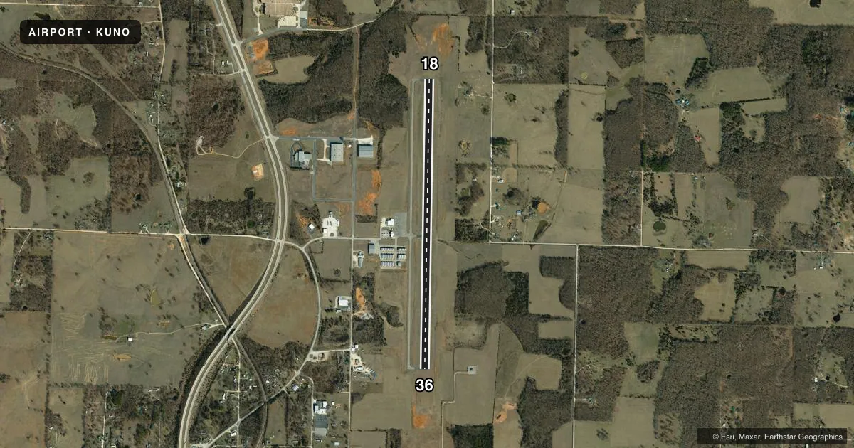
Airport sketch
Runways drawn to scale from FAA survey coordinates, rendered over satellite imagery. Not for navigation.
Approaches & charts
Services on the field
Fuel grades, oxygen, maintenance, ramp storage and lighting — as declared to the FAA by the airport operator.
Fuel & services
- Fuel
- 100LLA
- Airframe repair
- Not available
- Power plant repair
- Not available
- Other services
- AMB,INSTR
Ramp & ground
- Transient storage
- Tie-down
- Lighting schedule
- SEE RMK
- Beacon schedule
- SS-SR
- Beacon
- White / Green (civil land)(WG)
- Wind indicator
- Yes
- Segmented circle
- Yes
Fuel & FBOs
Cheapest 100LL and Jet A on the field and nearby. Always confirm with the FBO before taxi.
Airport notes
Surface conditions, obstructions, local procedures, lighting outages and other notes published with each FAA cycle.
General notes
- HELICOPTER OPS ON & INVOF ARPT.
- FOR CD CTC MEMPHIS ARTCC AT 901-368-8453/8449.
Lighting notes
- BCN LOCATED ON WATER TWR WEST OF ARPT.
- ACTVT MIRL RY 18/36; PAPI RYS 18; 36 & REIL RYS 18 & 36 AFT 2200 - CTAF.
- ULTRALIGHTS ON & INVOF APRT.
Other notes
- 1ALL
- 1FOR ATTENDANT AFTER 1700 CALL 417-256-2244 OR 417-257-4771.
VFR map & nearby airports
VFR sectional. Tap any ICAO chip to open that airport.
Key facts · KUNO
Answer card- ICAO
- KUNO
- Name
- WEST PLAINS RGNL
- Location
- WEST PLAINS, MISSOURI
- Elevation
- 1,228.3 ft MSL
- Traffic pattern altitude
- 2,228.3 ft MSL (1,000 AGL)
- Control tower
- Non-towered (use CTAF)
- Total runways
- 1
- Longest runway
- 18/36 · 5,101 ft
- Published ILS approaches
- 0
- Published frequencies
- 2
- Magnetic variation
- 2°
- Current flight rules
- VFR
- Current wind
- 240° at 7 kt
- Favored runway now
- RWY 18
West Plains Rgnl sits in West Plains, Missouri. Field elevation is 1,228.3 ft MSL. The airport has one runway, 18/36, which is 5,101 ft long. It is not towered. CTAF and UNICOM are both 122.8. No ILS approaches are published here.
For pattern work, use the published standard light piston pattern of 1,000 ft AGL. That puts the pattern at about 2,228.3 ft MSL based on the field elevation. The on-field FBO is West Plains Regional Airport. It carries AVGAS 100LL and Jet A Prist. The airport is attended all day. If you need an attendant after 1700, call the numbers in the Chart Supplement or the airport directly before arrival.
A few operational notes matter here. Medium intensity runway lights are on runway 18/36. PAPI is available on both ends. REILs are on both runway ends after 2200 on the CTAF frequency. Ultralight aircraft and helicopters are active on and near the airport, so keep a sharp scan in the pattern. For clearance delivery, contact Memphis ARTCC by phone. The beacon is on the water tower west of the airport. If you are planning a night arrival or a first visit, verify the current Chart Supplement and brief the lighting setup before you go.