METAR & TAF 7M9
7M9 does not publish a METAR.
Showing the nearest reporting station: KBPK (BAXTER COUNTY) · 30.9 NM away. Conditions at 7M9 may differ.
METAR · KBPK
Observed 15:53Z
KBPK 271553Z AUTO VRB03KT 10SM FEW070 32/23 A2997 RMK AO2 SLP134 T03170233
- Wind
- VAR @ 3 kt
- Visibility
- 10 SM
- Temp / Dew
- 32°C / 23°C
- Altimeter
- 29.97 inHg
- Clouds
- FEW
- Density alt
- 2,954 ft
- Ceiling
- Unlimited
- Rules
- VFR
Airport info & contacts
Manager on record, flight service, ARTCC, attendance schedule and pattern altitude — published by the FAA and refreshed every 28 days.
Location
- From city
- 1 NM S
- VFR sectional
- KANSAS CITY
- ARTCC
- ZME · MEMPHIS
- NOTAM facility
- JBR (NOTAM-D)
Airport manager
- Name
- ELBERT LAYNE
- Phone
- (870) 371-0756
- Address
- PO BOX 1015, SALEM AR 72576
Flight service · Hours
- FSS JBR
- JONESBORO1-800-WX-BRIEF
- Attendance
- Unattended
Frequencies
Tap any row to copy the frequency to your clipboard.
Runways & pattern
Full pagePattern entry · RWY 02
LEFT TRAFFICRunway end performance
| End | TORA | TODA | ASDA | LDA | VGSI | Approach lights | Obstruction |
|---|---|---|---|---|---|---|---|
| 02 | — | — | — | — | — | — | 50', hill, 200' from thr, 150' R of cntrln, slope 0 |
| 20 | — | — | — | — | — | — | 25', tree, 500' from thr, 75' R of cntrln, slope 12 |
Declared distances in feet. TORA = takeoff run available, TODA = takeoff distance, ASDA = accelerate-stop, LDA = landing distance.
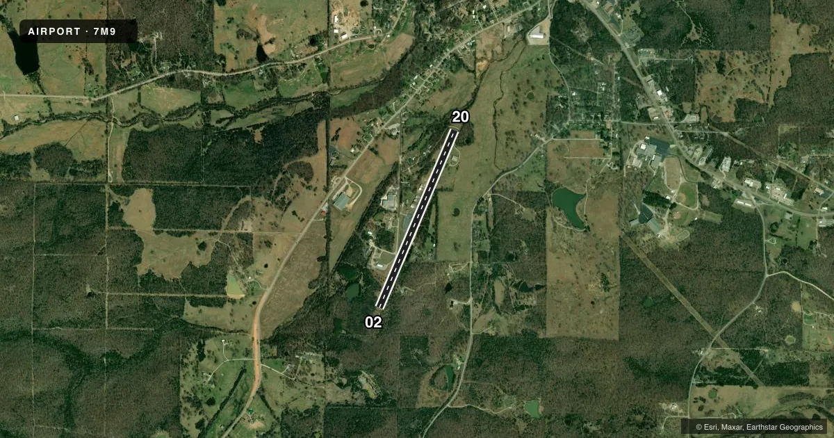
Airport sketch
Runways drawn to scale from FAA survey coordinates, rendered over satellite imagery. Not for navigation.
Approaches & charts
Services on the field
Fuel grades, oxygen, maintenance, ramp storage and lighting — as declared to the FAA by the airport operator.
Fuel & services
- Fuel
- 100LL
- Oxygen (bottled)
- Not available
- Oxygen (bulk)
- Not available
Ramp & ground
- Transient storage
- Tie-down
- Landing fee
- No fee published
- Customs
- Not available
- Lighting schedule
- SEE RMK
- Beacon schedule
- SS-SR
- Beacon
- White / Green (civil land)(WG)
- Wind indicator
- Lighted
- Segmented circle
- No
Fuel & FBOs
Cheapest 100LL and Jet A on the field and nearby. Always confirm with the FBO before taxi.
Airport notes
Surface conditions, obstructions, local procedures, lighting outages and other notes published with each FAA cycle.
General notes
- RY 02 HAS 3 FT DITCH AT END OF RY EXTENDING 700 FT ALONG EAST SIDE OF RY.
- ALL ACFT LAND RY 20; TKOF RY 02.
- DEER ON & INVOF RY.
- FOR CD CTC MEMPHIS ARTCC AT 901-368-8453/8449.
Lighting notes
- ACTVT MIRL RY 02/20 - CTAF.
Fuel notes
- 100LLFOR SVC CALL 870-371-0756 OR 870-371-1025 (NO FEE).
Approach & departure obstructions
- 02+50 FT HILL 20 FT FM THLD BOTH SIDES OF CNTRLN.
- 20+60 FT TREES 50 FT L OF CNTRLN 100 FT FM RY END; +10 FT ROAD 50 FT FM RY END.
- 02APCH SLOPE 14:1 TO DSPLCD THLD.
- 20APCH SLOPE 37:1 TO DSPLCD THLD.
- 02OBSTN LIGHT OTS INDEFLY.
VFR map & nearby airports
VFR sectional. Tap any ICAO chip to open that airport.
Key facts · 7M9
Answer card- ICAO
- 7M9
- Name
- SALEM
- Location
- SALEM, ARKANSAS
- Elevation
- 786.7 ft MSL
- Traffic pattern altitude
- 1,786.7 ft MSL (1,000 AGL)
- Control tower
- Non-towered (use CTAF)
- Total runways
- 1
- Longest runway
- 02/20 · 3,489 ft
- Published ILS approaches
- 0
- Published frequencies
- 1
- Magnetic variation
- 3°
- Current flight rules
- VFR
- Current wind
- 000° at 3 kt
- Favored runway now
- RWY 02
Salem Airport sits in Salem, Arkansas. Field elevation is 786.7 ft MSL. The airport has one runway. Runway 02/20 is 3,489 ft long and asphalt. There is no control tower. CTAF is 122.9.
No ILS approaches are published here. Pattern altitude is not published, so use the standard 1,000 ft AGL for light piston operations unless the current Chart Supplement says otherwise. The on-field FBO is Salem Airport. It carries AVGAS 100LL. Call (870) 371-0756 for fuel or current service details.
This field has several published runway notes that matter on arrival. Aircraft land on runway 20. Aircraft take off on runway 02. Runway 02 has an obstruction light out of service indefinitely. There is also a ditch along the east side near runway 02. A hill sits close to the threshold. Runway 20 has trees and a road near the departure end. Deer are reported on and near the runway, so keep a sharp scan on taxi, takeoff and landing. Medium intensity runway lights are activated by CTAF. For clearance delivery, contact Memphis ARTCC by phone before departure. A first-time pilot should plan a careful stabilized approach. Brief the displaced threshold notes. Verify current runway condition and lighting before going in.