METAR & TAF 6M2
6M2 does not publish a METAR.
Showing the nearest reporting station: KBVX (BATESVILLE RGNL) · 30.2 NM away. Conditions at 6M2 may differ.
METAR · KBVX
Observed 16:56Z
KBVX 271656Z AUTO 13005KT 10SM CLR 34/25 A2995 RMK AO2 SLP138 T03440250 $
- Wind
- 130° @ 5 kt
- Visibility
- 10 SM
- Temp / Dew
- 34°C / 25°C
- Altimeter
- 29.95 inHg
- Clouds
- CLR
- Density alt
- 3,212 ft
- Ceiling
- Unlimited
- Rules
- VFR
Airport info & contacts
Manager on record, flight service, ARTCC, attendance schedule and pattern altitude — published by the FAA and refreshed every 28 days.
Location
- From city
- 1 NM NE
- VFR sectional
- KANSAS CITY
- ARTCC
- ZME · MEMPHIS
- NOTAM facility
- JBR (NOTAM-D)
Airport manager
- Name
- ERIC SECRETAN
- Phone
- 304-268-3666
- Address
- 704 W COMMERCE, HORSESHOE BEND AR 72512
Flight service · Hours
- FSS JBR
- JONESBORO1-800-WX-BRIEF
- Attendance
- Unattended
Frequencies
Tap any row to copy the frequency to your clipboard.
Runways & pattern
Full pagePattern entry · RWY 13
LEFT TRAFFICRunway end performance
| End | TORA | TODA | ASDA | LDA | VGSI | Approach lights | Obstruction |
|---|---|---|---|---|---|---|---|
| 13 | — | — | — | — | — | — | 110', trees, 1200' from thr, 0' R of cntrln, slope 9 |
| 31 | — | — | — | — | PAPI 2-box left(3°) | — | 32', tree, 400' from thr, 225' R of cntrln, slope 6 |
Declared distances in feet. TORA = takeoff run available, TODA = takeoff distance, ASDA = accelerate-stop, LDA = landing distance.
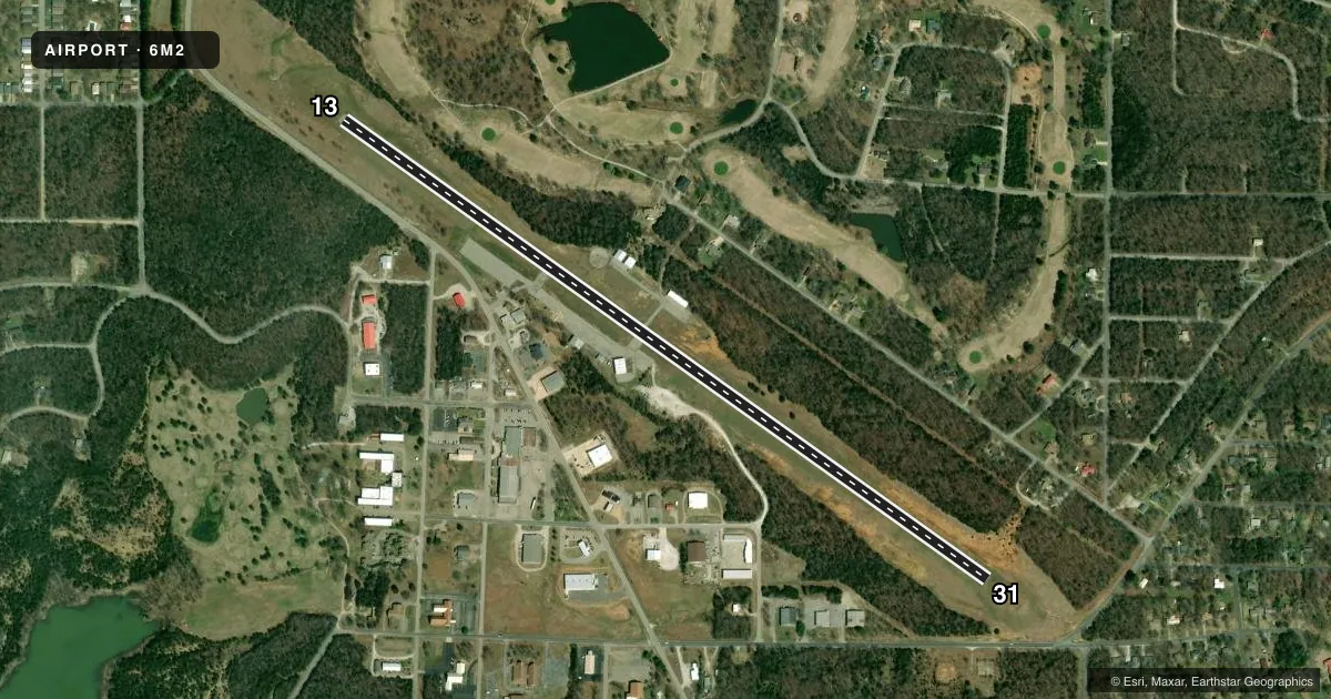
Airport sketch
Runways drawn to scale from FAA survey coordinates, rendered over satellite imagery. Not for navigation.
Approaches & charts
Services on the field
Fuel grades, oxygen, maintenance, ramp storage and lighting — as declared to the FAA by the airport operator.
Fuel & services
- Fuel
- 100LL
- Airframe repair
- Major
- Power plant repair
- Major
Ramp & ground
- Transient storage
- Tie-down
- Landing fee
- No fee published
- Customs
- Not available
- Lighting schedule
- SEE RMK
- Beacon schedule
- SS-SR
- Beacon
- White / Green (civil land)(WG)
- Wind indicator
- Lighted
- Segmented circle
- Yes
Fuel & FBOs
Cheapest 100LL and Jet A on the field and nearby. Always confirm with the FBO before taxi.
Airport notes
Surface conditions, obstructions, local procedures, lighting outages and other notes published with each FAA cycle.
General notes
- RWY 13 TKOF RCMDD DUE TO RAPIDLY RISING TRRN NW OF ARPT.
- DEER ON & INVOF ARPT.
- FOR CD CTC MEMPHIS ARTCC AT 901-368-8453/8449.
Lighting notes
- DUSK-DAWN ACTVT MIRL RWY 13/31 - CTAF. PAPI RWY 31 OPR CONSLY.
Fuel notes
- 100LLSELF SERVE FUEL H24 WITH CREDIT CARD.
Approach & departure obstructions
- 13RAPIDLY RISING TRRN WITH TREES FNA RWY 13. TRRN RISES 681 FT BTN 200-1100 FT FM RWY END.
VFR map & nearby airports
VFR sectional. Tap any ICAO chip to open that airport.
Key facts · 6M2
Answer card- ICAO
- 6M2
- Name
- HORSESHOE BEND
- Location
- HORSESHOE BEND, ARKANSAS
- Elevation
- 781.8 ft MSL
- Traffic pattern altitude
- 1,781.8 ft MSL (1,000 AGL)
- Control tower
- Non-towered (use CTAF)
- Total runways
- 1
- Longest runway
- 13/31 · 4,502 ft
- Published ILS approaches
- 0
- Published frequencies
- 2
- Magnetic variation
- 0°
- Current flight rules
- VFR
- Current wind
- 130° at 5 kt
- Favored runway now
- RWY 13
Horseshoe Bend Airport (6M2) is in Horseshoe Bend, Arkansas. Field elevation is 781.8 ft MSL. The airport has one runway, 13/31, which is 4,502 ft long and asphalt. There is no control tower. CTAF and UNICOM are both 122.8. No ILS approaches are published here.
The published pattern altitude is not listed. Use the standard 1,000 ft AGL pattern unless the current Chart Supplement says otherwise. The on-field FBO is Horseshoe Bend Municipal. It carries 100LL. Self-serve fuel is available 24 hours with credit card.
This is a field where terrain matters. The remarks call out rapidly rising terrain and trees on final to runway 13. Takeoff on runway 13 is recommended because of rapidly rising terrain northwest of the airport. Deer are also reported on and near the airport, so keep a sharp scan on taxi and in the pattern. From dusk to dawn, medium intensity runway lights are active on 13/31 and controlled by CTAF. The PAPI on runway 31 operates continuously. For clearance delivery, contact Memphis ARTCC before departure if you need it.