METAR & TAF 37T
37T does not publish a METAR.
Showing the nearest reporting station: KBPK (BAXTER COUNTY) · 19.9 NM away. Conditions at 37T may differ.
METAR · KBPK
Observed 15:53Z
KBPK 271553Z AUTO VRB03KT 10SM FEW070 32/23 A2997 RMK AO2 SLP134 T03170233
- Wind
- VAR @ 3 kt
- Visibility
- 10 SM
- Temp / Dew
- 32°C / 23°C
- Altimeter
- 29.97 inHg
- Clouds
- FEW
- Density alt
- 2,887 ft
- Ceiling
- Unlimited
- Rules
- VFR
Airport info & contacts
Manager on record, flight service, ARTCC, attendance schedule and pattern altitude — published by the FAA and refreshed every 28 days.
Location
- From city
- 3 NM N
- VFR sectional
- KANSAS CITY
- ARTCC
- ZME · MEMPHIS
- NOTAM facility
- JBR (NOTAM-D)
Airport manager
- Name
- DR. JOHN LANE
- Phone
- 870-291-1200
- Address
- P.O. BOX 216, CALICO ROCK AR 72519
Flight service · Hours
- FSS JBR
- JONESBORO1-800-WX-BRIEF
- Attendance
- Unattended
Frequencies
Tap any row to copy the frequency to your clipboard.
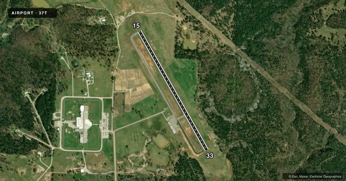
Runways & pattern
Full pagePattern entry · RWY 33
LEFT TRAFFICRunway end performance
| End | TORA | TODA | ASDA | LDA | VGSI | Approach lights | Obstruction |
|---|---|---|---|---|---|---|---|
| 15 | — | — | — | — | PAPI 2-box left(4°) | — | — |
| 33 | — | — | — | — | PAPI 2-box left(4°) | — | 35', trees, 930' from thr, 180' R of cntrln, slope 20 |
Declared distances in feet. TORA = takeoff run available, TODA = takeoff distance, ASDA = accelerate-stop, LDA = landing distance.
Airport sketch
Runways drawn to scale from FAA survey coordinates, rendered over satellite imagery. Not for navigation.
Approaches & charts
Services on the field
Fuel grades, oxygen, maintenance, ramp storage and lighting — as declared to the FAA by the airport operator.
Fuel & services
- Fuel
- Not available
Ramp & ground
- Transient storage
- Tie-down
- Lighting schedule
- SEE RMK
- Wind indicator
- Lighted
- Segmented circle
- No
Fuel & FBOs
Cheapest 100LL and Jet A on the field and nearby. Always confirm with the FBO before taxi.
Airport notes
Surface conditions, obstructions, local procedures, lighting outages and other notes published with each FAA cycle.
General notes
- FOR CD CTC MEMPHIS ARTCC AT 901-368-8453/8449.
Lighting notes
- ACTVT REIL RWY 15, 33; PAPI RWY 15, 33; MIRL RWY 15/33 - CTAF.
Approach & departure obstructions
- 15REIL RWY 15 OTS
Other notes
- AIRSPACE DETERMINATIOIN PENDING.
VFR map & nearby airports
VFR sectional. Tap any ICAO chip to open that airport.
Key facts · 37T
Answer card- ICAO
- 37T
- Name
- CALICO ROCK MUNI
- Location
- CALICO ROCK, ARKANSAS
- Elevation
- 733 ft MSL
- Traffic pattern altitude
- 1,733 ft MSL (1,000 AGL)
- Control tower
- Non-towered (use CTAF)
- Total runways
- 1
- Longest runway
- 15/33 · 3,002 ft
- Published ILS approaches
- 0
- Published frequencies
- 1
- Magnetic variation
- 3°
- Current flight rules
- VFR
- Current wind
- 000° at 3 kt
- Favored runway now
- RWY 33
Calico Rock Muni Airport (37T) sits in Calico Rock, Arkansas. Field elevation is 733 ft MSL. The airport has one runway. Runway 15/33 is 3,002 ft asphalt, which makes it the longest runway on the field. There is no control tower. Use CTAF 122.9 for traffic calls.
No ILS approaches are published here. The published remarks also note that airspace determination is pending, so check the current FAA Chart Supplement and the current sectional before you go. For clearance delivery, contact Memphis ARTCC at 901-368-8453 or 901-368-8449. Runway 15 and 33 have REILs, PAPI and medium intensity runway lights. That helps at night or in marginal visibility.
Pattern altitude is not published. Use the standard 1,000 ft AGL pattern unless the current Chart Supplement says otherwise. No on-field FBOs are listed, so plan to verify services with the airport operator or call the field directly before arrival. For a first-time arrival, the main things to sort out are the runway lighting, the unpublished airspace and the lack of tower service. The field is in north-central Arkansas. Watch your weather and terrain planning on the way in.